
Whiteface Mountain facts for kids
Quick facts for kids Whiteface Mountain |
|
|---|---|

Whiteface Mountain
|
|
| Highest point | |
| Elevation | 4,867 ft (1,483 m) NGVD 29 |
| Listing | #5 Adirondack High Peaks |
| Geography | |

Whiteface Mountain
Location in New York

Whiteface Mountain
Location in the United States
|
|
| Location | Wilmington, New York, U.S. |
| Parent range | Adirondacks |
| Topo map | USGS Lake Placid |
| Climbing | |
| First ascent | 1814 by John Richards and party |
| Easiest route | road |
Whiteface Mountain is the fifth-tallest mountain in New York. It is one of the special High Peaks in the Adirondack Mountains. You can find it in the town of Wilmington, in Essex County.
Whiteface stands a bit apart from the other High Peaks. This means you get amazing 360-degree views from the top! On clear days, you can see all the way to Vermont and even Canada. Sometimes, you can even spot the city of Montreal. Because it's so open, strong winds hit the mountain. It's often covered in snow and ice, which makes it a cool place for meteorologists (weather scientists) to study. They have been collecting weather information from the top since 1937.
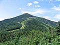
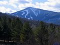
The east side of Whiteface Mountain has a huge ski area. It has the biggest vertical drop (the distance from top to bottom) of any ski area east of the Rocky Mountains. This ski area was even used for the alpine skiing events during the 1980 Winter Olympics.
What makes Whiteface unique among the High Peaks is that you can drive almost to the top! The Whiteface Veterans Memorial Highway (New York State Route 431) takes you to a parking area just below the summit. From there, you can walk through a tunnel and take an elevator to the very peak. You can also hike up the mountain using two different trails.
Contents
Exploring Whiteface Mountain
Whiteface Mountain is in Wilmington, Essex County, New York. It stands at 4,867 feet (1,483 m) tall. Except for a nearby mountain called Esther Mountain, Whiteface is over 10 miles (16 km) from the other tall Adirondack High Peaks. This distance means you get amazing views in every direction from the top. Many visitors come just for these views.
On clear days, you can see Lake Placid and the other High Peaks to the south and west. To the east, you can spot Lake Champlain and Vermont. And to the north, you might even see Montreal in Canada! The top 300 feet (91 m) of the mountain are above the treeline, meaning there are no trees growing there.
How Whiteface Mountain Was Formed
Whiteface Mountain is mostly made of a white rock called anorthosite. You can see this white rock near the top and where landslides have happened. The white rock, along with ice that covers the summit for ten months a year, gave Whiteface its name. Native American names also described it as "white head" or "it is white."
Like the rest of the Adirondack region, huge glaciers covered Whiteface Mountain during the last ice ages. These glaciers left behind cool features on the mountain's sides. The north, west, and east sides have bowl-shaped hollows called cirques, separated by sharp ridges called arêtes. One of these ridges is now a hiking trail. A long rock slide on the south side, called the Lake Placid slide, was an early path to the top.
Whiteface Mountain Weather
Because its top is bare and it's far from other mountains, Whiteface gets a lot of westerly winds. This makes it a perfect spot for studying weather. Scientists have been watching the weather here since 1937. That's when New York University and RPI set up a weather station. Since 1957, the University at Albany’s Atmospheric Sciences Research Center (ASRC) has been collecting data. In the 1970s and 1980s, they even studied cloud chemistry and acid rain over Whiteface.
Whiteface Mountain has a subarctic climate. This means it has very cold, snowy winters and cool, wet summers. On average, Whiteface Mountain gets about 190 inches of snow each year. The ski trails also have snowmaking machines to add more snow. In the 2016-2017 season, Whiteface got a record 281 inches of natural snow! On February 4, 2023, it got super cold, reaching a record low of −40.2 °F (−40.1 °C). A record wind speed of 121 miles per hour (195 km/h) was also recorded that day.
| Climate data for Whiteface Mountain, New York (1937-1946 normals, extremes 1937–1946) | |||||||||||||
|---|---|---|---|---|---|---|---|---|---|---|---|---|---|
| Month | Jan | Feb | Mar | Apr | May | Jun | Jul | Aug | Sep | Oct | Nov | Dec | Year |
| Record high °F (°C) | 42 (6) |
41 (5) |
63 (17) |
69 (21) |
73 (23) |
79 (26) |
78 (26) |
78 (26) |
75 (24) |
69 (21) |
57 (14) |
52 (11) |
79 (26) |
| Mean daily maximum °F (°C) | 16.3 (−8.7) |
17.8 (−7.9) |
26.3 (−3.2) |
36.3 (2.4) |
50.9 (10.5) |
59.6 (15.3) |
62.7 (17.1) |
59.9 (15.5) |
53.9 (12.2) |
42.1 (5.6) |
30.9 (−0.6) |
20.0 (−6.7) |
39.7 (4.3) |
| Daily mean °F (°C) | 7.5 (−13.6) |
8.4 (−13.1) |
17.5 (−8.1) |
28.2 (−2.1) |
42.6 (5.9) |
51.4 (10.8) |
55.3 (12.9) |
53.1 (11.7) |
46.1 (7.8) |
33.6 (0.9) |
23.5 (−4.7) |
11.4 (−11.4) |
31.6 (−0.3) |
| Mean daily minimum °F (°C) | −1.8 (−18.8) |
−1.1 (−18.4) |
8.7 (−12.9) |
20.1 (−6.6) |
34.2 (1.2) |
43.2 (6.2) |
47.9 (8.8) |
46.0 (7.8) |
38.3 (3.5) |
27.1 (−2.7) |
16.0 (−8.9) |
3.0 (−16.1) |
23.5 (−4.7) |
| Record low °F (°C) | −36 (−38) |
−40 (−40) |
−35 (−37) |
−18 (−28) |
9 (−13) |
16 (−9) |
28 (−2) |
28 (−2) |
16 (−9) |
6 (−14) |
−10 (−23) |
−34 (−37) |
−40 (−40) |
| Average precipitation inches (mm) | 4.11 (104) |
3.76 (96) |
3.27 (83) |
4.26 (108) |
3.84 (98) |
3.26 (83) |
4.20 (107) |
3.56 (90) |
4.48 (114) |
3.71 (94) |
4.08 (104) |
4.27 (108) |
46.80 (1,189) |
| Average snowfall inches (cm) | 27.0 (69) |
29.7 (75) |
19.2 (49) |
11.4 (29) |
1.1 (2.8) |
0.0 (0.0) |
0.0 (0.0) |
0.0 (0.0) |
0.2 (0.51) |
10.1 (26) |
23.2 (59) |
17.8 (45) |
139.7 (355.31) |
| Source: Northern Regional Climate Center | |||||||||||||
Whiteface Mountain Ski Area
| Whiteface Mountain Ski Area | |
|---|---|
 |
|
| Location | Wilmington, New York, U.S. |
| Nearest city | Lake Placid - 13 miles (21 km) |
| Coordinates | 44°21′57″N 73°54′10″W / 44.36583°N 73.90278°W |
| Vertical | 3,166 ft (965 m) (lift-served) 3,430 ft (1,045 m) |
| Top elevation | 4,386 ft (1,337 m) (lift-served) 4,650 ft (1,417 m) |
| Base elevation | 1,220 ft (372 m) |
| Skiable area | 299 acres (121 ha) |
| Runs | 94 total |
| Lift system | 1 gondola 9 chairlifts 1 conveyor lift |
| Terrain parks | 7 |
| Snowfall | 190 in (480 cm) |
| Snowmaking | yes |
| Night skiing | no |
| Website | Whiteface.com |
The Whiteface ski area opened in 1960. It is managed by the Olympic Regional Development Authority. This ski area was a big part of the 1980 Winter Olympics. It hosted all six of the alpine ski events. Whiteface also hosted events for the 2000 Goodwill Winter Games. More recently, it was used for alpine skiing at the 2023 Winter World University Games.
Whiteface ski area has 94 trails that stretch over 24 miles (39 km) across 299 acres (121 ha) of land. The highest ski lift takes you to 4,386 feet (1,337 m). This means a huge vertical drop of 3,166 ft (965 m) down to the base area at 1,220 ft (372 m). There's also an area called The Slides that you can hike to. It's 264 ft (80 m) higher, at 4,650 ft (1,417 m). This gives Whiteface the biggest continuous vertical drop in eastern North America at 3,430 feet (1,045 m). The Slides also add 35 acres (14 ha) of challenging ski terrain.
The longest run you can ski is the Wilmington Trail, which is 2.1 miles (3.4 km) long. To get around the ski area, there's one gondola, nine chairlifts, and one conveyor lift. Almost all the trails (99%) have snowmaking coverage, so there's usually plenty of snow for skiing!
History of Whiteface Mountain
The first time someone officially climbed Whiteface was in 1814. A surveyor named John Richards made the climb. Whiteface was the first mountain in the Adirondacks to become popular with tourists. This was because it was close to Lake Placid. By 1859, there was already a trail to the top from nearby Wilmington.
In July 1909, a fire lookout station was set up on the mountain. At first, it was just a simple tent. Later, it was improved to a stone hut. In 1919, a 22-foot-tall (6.7 m) steel tower was built. In 1930, a 46-foot-tall (14 m) memorial tower was built to honor World War veterans. This tower had a 60 inches (150 cm) revolving light.
The fire tower was closed in 1970 because planes started being used more to spot fires. In 1972, the fire tower was removed. It was later given to the Adirondack Museum at Blue Mountain Lake.
The Whiteface Mountain Veterans Memorial Highway and Whiteface Castle were planned before the Great Depression. The state of New York paid for the whole project. Construction began in 1929 under Governor Franklin D. Roosevelt. It cost 1.25 million dollars. The highway officially opened on July 20, 1935. It was dedicated to veterans of the Great War in a ceremony with President Roosevelt on September 14, 1935.
In 1941, New York voters approved money to build a ski area on Whiteface. This ski area, called Marble Mountain, operated from 1948 to 1960. However, strong winds often blew the snow away, making skiing difficult. Because of the poor conditions, Marble Mountain was closed. The modern ski area was built in 1957. The old Marble Mountain base lodge is now used by the Atmospheric Sciences Research Center for weather observations.
Getting to the Top
The Veterans Memorial Highway is 5 miles (8 km) long. It goes up the mountain and stops 300 feet (91 m) below the very top. This highway is usually open for cars from May to October. At the end of the highway is Whiteface Castle, a building made of stone and concrete.
From the parking lot next to the castle, there are two ways to reach the summit:
- The first way is the Stairway Ridge Trail. This is a walking path with handrails and steps. It's about 0.2 miles (0.32 km) long.
- The second way is a 426-foot (130 m) long tunnel that goes into the mountain. At the end of the tunnel, there's an elevator that takes you straight up to the summit.
You can also hike to the summit using two different trails. One trail starts in Wilmington, and the other starts near Lake Placid and Connery Pond.
The trail from Connery Pond starts at a parking lot on New York State Route 86. It climbs 3,232 feet (985 m) to the summit. You can also start this trail by crossing Lake Placid by boat to Whiteface Landing. This cuts off 2.7 miles (4.3 km) from the start, leaving 3.5 miles (5.6 km) to hike to the summit.
The Wilmington Trail begins on the Veterans Memorial Highway. It's 5.2 miles (8.4 km) long to the summit, with a climb of 3,620 feet (1,100 m). This trail crosses ski trails and lifts. It also connects to an unmarked path to the top of nearby Esther Mountain. You can also reach the Wilmington Trail from the Marble Mountain Trail. This trail starts at another parking lot on New York State Route 86.
Gallery
-
Whiteface Mountain
-
Whiteface Mountain from near Franklin Falls NY
-
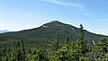
Whiteface Mountain as seen from Esther Mountain
-
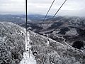
View from the Cloudsplitter Gondola on the way to the summit of Little Whiteface
-
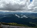
A view of nearby Lake Placid from the summit of Whiteface Mountain


.JPG)


