
Rindge, New Hampshire facts for kids
Quick facts for kids
Rindge, New Hampshire
|
||
|---|---|---|
|
Town
|
||

Rindge Center
|
||
|
||

Location in Cheshire County, New Hampshire
|
||
| Country | United States | |
| State | New Hampshire | |
| County | Cheshire | |
| Incorporated | 1768 | |
| Villages |
|
|
| Area | ||
| • Total | 39.8 sq mi (103.1 km2) | |
| • Land | 37.1 sq mi (96.1 km2) | |
| • Water | 2.7 sq mi (7.0 km2) 6.76% | |
| Elevation | 1,296 ft (395 m) | |
| Population
(2020)
|
||
| • Total | 6,476 | |
| • Density | 175/sq mi (67.4/km2) | |
| Time zone | UTC−5 (Eastern) | |
| • Summer (DST) | UTC−4 (Eastern) | |
| ZIP code |
03461
|
|
| Area code(s) | 603 | |
| FIPS code | 33-64580 | |
| GNIS feature ID | 0873707 | |

Rindge is a town located in Cheshire County, New Hampshire, in the United States. In 2020, about 6,476 people lived here. Rindge is known for Franklin Pierce University, the Cathedral of the Pines, and part of Annett State Forest.
Contents
History of Rindge
Early Native American Life
The land where Rindge is now was first home to the ancestors of the Abenaki tribe. These were Native American groups. Scientists have found old tools and signs of life nearby. This shows people lived in the area up to 11,000 years ago. This was around the end of the last Ice Age.
Sadly, many Western Abenaki people got sick from diseases. These diseases came with Europeans in the late 1500s and early 1600s. Later, many Abenaki from southwestern New Hampshire moved to Canada. They did this because they were allies with the French during the French and Indian Wars.
European Settlement and Town Naming
In the 1700s, the Massachusetts government gave land to soldiers. These soldiers had fought in a war against French-held Canada in 1690. Whole towns were given to military groups. These places were called "Canada" townships.
Rindge was first called "Rowley-Canada" in 1736. It was given to soldiers from Rowley, Massachusetts. But there were arguments over who owned the land. In 1740, the King's officials decided the border between Massachusetts and New Hampshire. This border was south of Rowley-Canada.
So, in 1749, the land was given again. Governor Benning Wentworth called it "Monadnock No. 1." In 1768, Governor John Wentworth officially made it a town. He named it "Rindge" to honor Captain Daniel Rindge. Captain Rindge was one of the first people to get land there. He also helped New Hampshire claim the land before the king.
Captain Abel Platts was the first person to live in Rindge for a short time. He arrived in 1738 to claim his family's land. But arguments about land and a war starting in 1744 made it hard to stay. So, early settlers left. Platts and others came back in 1752. By 1758, more and more people settled there.
By 1859, Rindge had 1,274 residents. Many businesses used water power. There were mills for grinding grain, cutting wood, and making roof shingles. There were also mills for making barrels and wooden siding for houses.
-
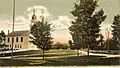
The Common in 1906
-
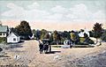
West Rindge in 1910
-
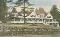
Pinecroft Inn around 1915
-
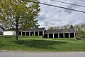
Historic horse sheds behind the meeting house


Geography and Natural Features
Rindge covers about 103.1 square kilometers (40 square miles). Most of this is land (96.1 km² or 37.1 sq mi). About 7.0 km² (2.7 sq mi) is water, which is about 6.76% of the town.
Rindge is in a hilly area with many lakes. Some of the lakes include Hubbard Pond, Contoocook Lake, Pearly Lake, and Lake Monomonac. The town is also where two river systems begin. The Contoocook River flows north to the Merrimack River. This river then goes into the Gulf of Maine. The North Branch of the Millers River flows southwest. It goes to the Connecticut River, then to Long Island Sound.
The highest point in Rindge is on its eastern border. It's on the lower part of Pratt Mountain. This spot is about 1,505 feet (459 meters) above sea level.
Rindge has several small communities called villages. These include Rindge Center, East Rindge, Converseville, and West Rindge. Major roads like U.S. Route 202 and New Hampshire Route 119 pass through the town.
Neighboring Towns
Rindge shares its borders with these towns:
- Jaffrey (north)
- Sharon (northeast)
- New Ipswich (east)
- Ashburnham, Massachusetts (southeast)
- Winchendon, Massachusetts (south)
- Fitzwilliam (west)
Population and People

In 2020, Rindge had 6,476 people living in 2,031 households. The town had about 67.4 people per square kilometer (174.1 per square mile). There were 2,361 housing units.
Most people in Rindge are White (91.17%). There are also people who identify as African American (2.83%), Asian (1.10%), and American Indian and Alaskan Native (0.29%). Some people are from two or more races (3.91%). About 3.07% of the population is Hispanic or Latino.
In 2010, there were 6,014 people in Rindge. There were 1,805 households. About 33.1% of these households had children under 18. Most households (63.0%) were married couples.
The population was spread out by age. About 29.6% were under 20 years old. About 20.7% were between 20 and 29. The median age was 29.7 years.
From 2013 to 2017, the average income for a household in Rindge was $68,250. For families, it was $82,917. The average income per person was $27,363. A small number of families (3.7%) and people (9.6%) lived below the poverty line.
Education in Rindge
Rindge is part of the Jaffrey-Rindge Cooperative School District. This district has three schools. Rindge is also home to Franklin Pierce University.
Colleges and Universities
- Franklin Pierce University
Public Schools
- Conant Middle High School (located in Jaffrey)
- Rindge Memorial School
- Jaffrey Grade School (located in Jaffrey)
Private Schools
- Hampshire Country School
- Heritage Christian School
Places to Visit

- Annett State Forest: This forest has Annett Wayside Park. It has picnic tables, restrooms, and a hiking trail to Black Reservoir.
- Cathedral of the Pines: This is a special memorial for all American soldiers who died in wars. A young man named Lieutenant Sanderson Sloane and his wife planned to build their home here. But he was lost when his bomber plane was shot down in Germany in 1944. His parents then created this cathedral in his memory.
- The Rindge Meeting House: This building was built in 1796. It's one of the biggest town meeting houses in northern New England. It's also one of the few public buildings that still has a connection to a church. The town owns the building. The First Congregational Church uses the second floor for services. The first floor is still used for town meetings and community events.
Notable People from Rindge
Many interesting people have come from Rindge, including:
- George P. Barker (1807–1848), a state congressman from New York
- Addison Gardiner (1797–1883), a Chief Judge and lieutenant governor of New York
- Enoch Hale (1733–1813), a military colonel
- Nathan Hale (1743–1780), a military officer and hero of the American Revolutionary War
- Amasa Norcross (1824–1898), a U.S. congressman
- Edward Payson (1783–1827), a preacher
- Mary Lee Ware (1858–1937), a farmer, helper of others, and supporter of Harvard's Glass Flowers collection
- Marshall Pickney Wilder (1798–1886), a merchant, gardener, and politician
See also
 In Spanish: Rindge (Nuevo Hampshire) para niños
