
Ashburnham, Massachusetts facts for kids
Quick facts for kids
Ashburnham, Massachusetts
|
|||
|---|---|---|---|

Ashburnham Town Hall
|
|||
|
|||

Location in Worcester County and the state of Massachusetts.
|
|||
| Country | United States | ||
| State | Massachusetts | ||
| County | Worcester | ||
| Settled | 1736 | ||
| Incorporated | 1765 | ||
| Government | |||
| • Type | Open town meeting | ||
| Area | |||
| • Total | 41.0 sq mi (106.2 km2) | ||
| • Land | 38.7 sq mi (100.2 km2) | ||
| • Water | 2.3 sq mi (6.0 km2) | ||
| Elevation | 1,028 ft (313 m) | ||
| Population
(2020)
|
|||
| • Total | 6,315 | ||
| • Density | 154.02/sq mi (59.46/km2) | ||
| Time zone | UTC−5 (Eastern) | ||
| • Summer (DST) | UTC−4 (Eastern) | ||
| ZIP Code |
01430
|
||
| Area code | 351/978 | ||
| FIPS code | 25-01885 | ||
| GNIS feature ID | 0618356 | ||
| Website | www.ashburnham-ma.gov | ||


Ashburnham is a town located in Worcester County, Massachusetts, in the United States. In 2020, about 6,315 people lived there. It is known for being the home of Cushing Academy, a private boarding school.
Ashburnham also includes a smaller area called South Ashburnham.
Contents
History of Ashburnham
.jpg)
Ashburnham was first settled by European people in 1736. It officially became a town in 1765. The town's name likely comes from a place in Britain, possibly linked to the Earl of Ashburnham or a community called Ashburnham in Sussex.
Before it became an official town, the area was known as the "Plantation of Dorchester-Canada." This land was given to officers and soldiers who took part in a trip to Canada in 1690.
Geography of Ashburnham
Ashburnham covers about 41 square miles (106 square kilometers). Most of this area is land, with about 2.3 square miles (6 square kilometers) being water. The town has two main types of land:
- The eastern part is hilly.
- The western part is flatter and higher up.
In the eastern part, you can find hills like Mount Watatic and Little Watatic Mountain. The western part of Ashburnham has several lakes, including Lake Wampanoag, Sunset Lake, and Lake Watatic. These lakes are important because they feed into the Millers River.
Ashburnham is in the northeastern corner of Worcester County. It shares borders with other counties and states. To the east, it borders Middlesex County. To the north, it borders Cheshire and Hillsborough County, New Hampshire in New Hampshire.
Nearby towns include Ashby to the east, Gardner to the southwest, and Winchendon to the west. Ashburnham is about 29 miles north of Worcester and 50 miles northwest of Boston.
Climate in Ashburnham
Ashburnham experiences all four seasons. Summers are generally warm, while winters are cold and snowy. Spring and autumn bring milder temperatures and colorful changes in nature.
Transportation in Ashburnham
Ashburnham does not have any major highways like interstates. The closest main highway, Route 2, passes through nearby towns like Fitchburg.
Several state routes run through Ashburnham:
- Route 12 goes from east to west.
- Route 101 starts in Ashburnham and goes north.
- Route 119 also passes through the town.
There are no traffic lights in Ashburnham.
An old railroad line, the Springfield Terminal Railroad, goes through the town. The Montachusett Regional Transit Authority (MART) provides bus and shuttle services for Ashburnham and the surrounding area.
For air travel, there are two small airports nearby: Fitchburg Municipal Airport and Gardner Municipal Airport. For bigger flights, the closest major airport is Manchester-Boston Regional Airport in New Hampshire.
Population of Ashburnham
| Historical population | ||
|---|---|---|
| Year | Pop. | ±% |
| 1850 | 1,875 | — |
| 1860 | 2,108 | +12.4% |
| 1870 | 2,172 | +3.0% |
| 1880 | 1,666 | −23.3% |
| 1890 | 2,074 | +24.5% |
| 1900 | 1,882 | −9.3% |
| 1910 | 2,107 | +12.0% |
| 1920 | 2,012 | −4.5% |
| 1930 | 2,079 | +3.3% |
| 1940 | 2,255 | +8.5% |
| 1950 | 2,603 | +15.4% |
| 1960 | 2,758 | +6.0% |
| 1970 | 3,484 | +26.3% |
| 1980 | 4,075 | +17.0% |
| 1990 | 5,433 | +33.3% |
| 2000 | 5,546 | +2.1% |
| 2010 | 6,081 | +9.6% |
| 2020 | 6,315 | +3.8% |
| 2023* | 6,415 | +1.6% |
| * = population estimate. Source: United States Census records and Population Estimates Program data. |
||
In 2000, Ashburnham had 5,546 people living there. About 42% of the households had children under 18. The average household had about 2.87 people.
The population's age breakdown in 2000 showed:
- 29% were under 18 years old.
- About 31% were between 25 and 44 years old.
- About 9% were 65 years or older.
The average age in town was 37 years.
In 2010, the average income for a household in Ashburnham was $76,250. A small number of families and people lived below the poverty line.
Education in Ashburnham
Ashburnham is part of the Ashburnham-Westminster Regional High School district. This district also includes the nearby town of Westminster.
Students in Ashburnham attend different schools based on their age:
- Elementary school students (Kindergarten to 5th grade) go to John R. Briggs Elementary School.
- Middle school students attend Overlook Middle School.
- High school students go to Oakmont Regional High School.
There is also a private school in town called Cushing Academy.
Places to Visit in Ashburnham
Ashburnham has several interesting places to visit:
- The Wapack Trail and Massachusetts Midstate Trail both start here. These are popular trails for hiking.
- The Cambridge Grant Historic District is a historical area.
- Mount Watatic is a mountain that was named one of the "1,000 places to visit in Massachusetts."
- You can find the Frederick historic piano collection in town.
- Camp Winnekeag is another notable spot.
Famous People from Ashburnham
Many interesting people have connections to Ashburnham:
- Ivers Whitney Adams: He founded Boston's first baseball team, the Boston Red Stockings. He also helped bring water to the town.
- Melvin O. Adams: A lawyer who was born in Ashburnham.
- Nate Berkus: A well-known designer and TV personality who graduated from Cushing Academy.
- Bette Davis: A famous actress who attended Cushing Academy and graduated in 1927.
- Isaac Hill: A politician who served as a U.S. Senator and governor of New Hampshire.
- Amos Pollard: A surgeon who was part of the famous Battle of the Alamo.
- Hans Rickheit: A cartoonist who grew up in Ashburnham.
- Cassius Clement Stearns: A composer of church music.
- Jigme Khesar Namgyal Wangchuck: The King of Bhutan, who also graduated from Cushing Academy.
Images for kids
-
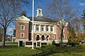
Ashburnham Town Hall
-
Seal of Ashburnham, Massachusetts
-

Flag of Ashburnham, Massachusetts
-
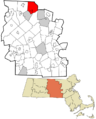
Location in Worcester County and the state of Massachusetts.
See also
 In Spanish: Ashburnham (Massachusetts) para niños
