
Ashby, Massachusetts facts for kids
Quick facts for kids
Ashby, Massachusetts
|
|||
|---|---|---|---|

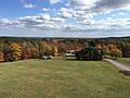
Aerial photo of Ashby, looking toward the center of town (this was taken prior to the construction of the public safety building).
|
|||
|
|||

Location in Middlesex County in Massachusetts
|
|||
| Country | United States | ||
| State | Massachusetts | ||
| County | Middlesex | ||
| Settled | 1676 | ||
| Incorporated | 1767 | ||
| Government | |||
| • Type | Open town meeting | ||
| Area | |||
| • Total | 24.2 sq mi (62.6 km2) | ||
| • Land | 23.8 sq mi (61.6 km2) | ||
| • Water | 0.4 sq mi (1.0 km2) | ||
| Elevation | 904 ft (276 m) | ||
| Population
(2020)
|
|||
| • Total | 3,193 | ||
| • Density | 131.94/sq mi (51.01/km2) | ||
| Time zone | UTC−5 (Eastern) | ||
| • Summer (DST) | UTC−4 (Eastern) | ||
| ZIP Code |
01431
|
||
| Area code(s) | 351/978 | ||
| FIPS code | 25-01955 | ||
| GNIS feature ID | 0618214 | ||
| Website | https://www.ashbyma.gov/ | ||


Ashby is a town in Middlesex County, Massachusetts, United States. In 2020, the population was 3,193. This makes Ashby the smallest town by population in Middlesex County.
Ashby is mostly a residential area, meaning most people live in single-family homes. There are only a few businesses. A big part of the Willard Brook State Forest is in Ashby. This forest includes Damon Pond, Trap Falls, and many miles of hiking trails.
Contents
Geography of Ashby
Ashby covers about 24.2 square miles (62.6 square kilometers). Most of this area, about 23.8 square miles (61.6 square kilometers), is land. The rest, about 0.4 square miles (1.0 square kilometer), is water.
Ashby is located in the northwestern part of Middlesex County. It shares borders with:
- New Ipswich, New Hampshire (to the north)
- Mason, New Hampshire (to the north)
- Townsend (to the east)
- Lunenburg (to the southeast)
- Fitchburg (to the south)
- Ashburnham (to the west)
Ashby is unique because it only borders one other town in its own county (Townsend).
Getting Around Ashby
Route 31 goes through Ashby from north to south. Route 119 goes from east to west. These two routes briefly join together just east of the town center.
Ashby is part of the Montachusett Regional Transit Authority (MART). However, there are no regular public buses or trains directly to Ashby. The closest public transportation is in Fitchburg, which is to the south.
People of Ashby
| Historical population | ||
|---|---|---|
| Year | Pop. | ±% |
| 1850 | 1,208 | — |
| 1860 | 1,091 | −9.7% |
| 1870 | 994 | −8.9% |
| 1880 | 914 | −8.0% |
| 1890 | 825 | −9.7% |
| 1900 | 876 | +6.2% |
| 1910 | 885 | +1.0% |
| 1920 | 834 | −5.8% |
| 1930 | 982 | +17.7% |
| 1940 | 1,026 | +4.5% |
| 1950 | 1,464 | +42.7% |
| 1960 | 1,883 | +28.6% |
| 1970 | 2,274 | +20.8% |
| 1980 | 2,311 | +1.6% |
| 1990 | 2,717 | +17.6% |
| 2000 | 2,845 | +4.7% |
| 2010 | 3,074 | +8.0% |
| 2020 | 3,193 | +3.9% |
| 2022* | 3,163 | −0.9% |
| * = population estimate. Source: United States Census records and Population Estimates Program data. |
||
In 2010, there were 3,074 people living in Ashby. There were 1,105 households, and 862 of these were families. The town had about 129 people per square mile.
Most people in Ashby (97.1%) were White. About 1.9% of the population was Hispanic or Latino.
About 34.1% of households had children under 18 living with them. Most households (66.5%) were married couples living together. The average household had 2.86 people.
The median age in Ashby was 42.6 years old. This means half the people were older than 42.6 and half were younger. About 24.5% of the population was under 18 years old.
_-_Ashby,_Massachusetts.JPG)
History of Ashby
How Ashby Started
Ashby was first settled in 1676 and became an official town in 1767. It was created from parts of other towns like Townsend, Lunenburg, Fitchburg, and Ashburnham.
One of the first settlers was John Fitch. He was kidnapped by Native Americans in 1748 and held for six months. He died in 1795, but his children stayed in Ashby. Today, there's a monument called the "John Fitch Monument" at the intersection of South and Richardson roads. Volunteers cleaned it up in 2021.
Even though some mills existed, Ashby was mostly a farming community in the 1700s and 1900s. Much of the land was used for farms. Ashby also had many apple orchards, and you can still find traces of them in the woods today.
Interesting Places in Ashby
Ashby Historical Society

The Ashby Historical Society started in 1900. Its goal is to save Ashby's history for future generations. The society has a small museum in the old engine house in the center of town. This building was built around 1899.
The museum has many items from Ashby's past. These include maps, books, letters, furniture, farm tools, and old firefighting equipment. You can see hand-pumped fire engines and other fire tools there.
"The Town Pump" Newsletter
"The Town Pump" was a newsletter published during the last two years of World War II. The first issue came out in June 1944, and the last in September 1945. This newsletter helped keep Ashby residents who were away supporting the war effort informed about what was happening back home. You can find digital copies of "The Town Pump" online.
The Ashby Stock Farm
The Ashby Stock Farm is a large open area in town. It has 238 acres of hay fields and forest. This farm used to be much bigger, stretching all the way to downtown and up to the New Hampshire border. It has had several owners and was once a big dairy farm. Today, it is privately owned and has horses, and they still produce hay there.
Gazebo and Town Common
The Ashby town common is a well-known spot for anyone traveling on Route 119. It's a medium-sized, triangular piece of land in the center of town. It's located on a hill in front of one of the two historic churches still standing. The common used to have many maple trees, but many have died and been removed. The gazebo has been there since the 1800s and was restored in the 2000s.

South Village (Mill Village)
The South Village area is also known as the "Mill Village" on some old maps. This area is around the Ashby Reservoir's outlet. A gristmill (for grinding grain) and some mill housing were built here by Ephraim Hayward around 1800.
Two of these old buildings still exist today. They are owned by the Middlesex County Foundation and are used by Camp Middlesex as a seasonal 4-H camp. The mill buildings, dam, and bridge have been kept up over the years. The bridge over the spillway was replaced in the 2000s.
The mills changed owners many times. William O. Loveland eventually ran the sawmill and changed the gristmill to make electricity. It's believed that Loveland convinced the town to install poles and bring electricity to light the town center around 1902. The mills finally closed in the 1920s.
Cemeteries
Ashby has three historic cemeteries:
- First Parish Burial Ground: Also called the "Old Burial Ground," it was started on the common in 1767.
- Glenwood Cemetery: This is newer than the others and was built in 1867.
- West Cemetery: This was originally a family burial ground from the Revolutionary War. Later, many Finnish families used it in the 1900s. The town now owns and takes care of all these cemeteries.
Watatic Ski Area
Mount Watatic, located in Ashburnham and Ashby, used to have a small ski area. It operated from the 1930s until it closed in 1984. The ski area started with a small rope tow and later expanded to the top of the mountain, probably in the 1960s.
At its busiest, the ski area had snow-making machines and night skiing, which were impressive for the time. It also had several rope tows, two T-bars, and double chairs. In 1984, the ski area closed because of competition and its location away from major roads. There was one attempt to reopen it in 1988 as Ski Adventure, but it didn't work out.
The land where the ski area used to be is now protected for nature. People can hike there. Hikers can still find the old, overgrown trails and parts of the old buildings on the back side of the mountain.
Mount Watatic also had a state fire tower (number 31) that stood 1590 feet above sea level. It offered views over central Massachusetts.
Recent History
250th Parade and Celebration
In 2017, Ashby celebrated its 250th anniversary. There were many events throughout the year, including:
- A parade
- Tours of the historical society
- A camp meeting
- Horse demonstrations
- An old-fashioned baseball game
- A bonfire
- And many other activities!
Ashby Free Public Library

The Ashby Free Public Library is a public library. It was started in 1874, largely thanks to Rev. George S. Shaw. In the 1890s, it was located in a private house and open on Tuesday and Friday afternoons. Around 1890, the library had 1,584 books.
In 1901, a businessman and Civil War veteran named Edwin Chapman donated a new building for the library. It opened in 1902.
In the early 2000s, Ashby's historic library was expanded and renovated inside. It used a "passive solar" technique, which means it was designed to use the sun's energy for heating and lighting. It became a model library for the Massachusetts Board of Library Commissioners (MBLC).
Education in Ashby
Ashby is part of the North Middlesex Regional School District. This district also includes the towns of Pepperell and Townsend.
Ashby has its own elementary school, Ashby Elementary School. Middle school students from Ashby go to Hawthorne Brook Middle School. High school students attend North Middlesex Regional High School.
Willard Brook State Forest
The town of Ashby is home to a large part of the Willard Brook State Forest. The Massachusetts Department of Conservation and Recreation manages this forest. Willard Brook has 2,597 acres of land with different types of terrain.
The state forest has places for camping, cooking, swimming, and picnicking. You can find information about the forest's hours and what it offers on the Commonwealth of Massachusetts website.
Damon Pond

Damon Pond is a swimming pond made by people. It was built by the CCC between 1933 and 1940. The pond was created by building a dam in an area of Willard Brook.
Hiking Trails
The forest has many trails for hiking, horseback riding, and mountain biking. In the winter, you can go cross-country skiing and snowmobiling. Local snowmobile groups groom and maintain many trails in the winter to make them safe and easy to use.
The Friends and Family Loop Trail is a walking trail that is four miles long. It's good for all ages and connects to the Pearl Hill State Forest.

Trap Falls
Trap Falls is a waterfall in the Willard Brook State Forest. It is about 10 to 12 feet high. How strong the waterfall is depends on the time of year. It flows strongest in the spring and early summer.
The falls are fed by Trap Fall Brook. This brook starts near the New Hampshire border and flows southeast. It eventually joins Willard Brook after going under Route 119.
The falls are a short walk from a parking area along Route 119. There is a walking bridge at the bottom of the falls, which lets you cross to the other side.
Local Events in Ashby

The small town of Ashby hosts several community events each year:
- Ashby July 3 Bonfire
- Summer Night Band Concerts on The Common (July – August)
- 911 Ceremony
- Winter Holiday Band Concert
- Farmers Markets on The Common
- Annual Car Show For Veterans
- Pumpkin Festival and Tractor Parade
- Memorial Day Parade
- Halloween Downtown Trick or Treat
Ashby Fire Department
The Ashby Fire Department is located at 1093 Main Street. It provides fire protection, rescue services, and EMS (Emergency Medical Services) to the town. The department has a mix of paid, on-call, and volunteer staff.
They also offer other services like permits, inspections, and CPR classes. The department has three fire engines, one tanker, one forestry truck, a chief's car, a utility pickup, and two UTVs. They also have two ambulances for basic life support.
Ashby Police Department
The Ashby Police Department (APD) is in charge of law enforcement and investigating crimes in Ashby. The department includes:
- One Chief of Police
- One Sergeant
- Five full-time Patrolmen
- One Reserve Police Officer
The Ashby Police Department is currently in a double-wide trailer. This trailer used to be a classroom at the nearby Ashby Elementary School. The building is old and doesn't have many basic police functions. For example, it doesn't have a place to hold prisoners. Prisoners who need to be held must be taken to other police stations, and Ashby has to pay those towns for holding them.
In 2014, the station was connected to an electrical generator. This allows the building to stay fully working during power outages. The town has tried to build a new police station since 2006, but it hasn't happened yet.
Besides police officers, the station also has signal operators (dispatchers) who handle calls for both police and fire services.
Notable Person from Ashby
- Lisa Anne Fletcher (1844–1905), a poet, artist, and writer.
Images for kids
-
Aerial photo of Ashby, looking toward the center of town.
-

Seal of Ashby, Massachusetts.
-

Flag of Ashby, Massachusetts.
-
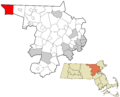
Location of Ashby in Middlesex County, Massachusetts.
See also
 In Spanish: Ashby (Massachusetts) para niños
