Pepperell, Massachusetts facts for kids
Quick facts for kids
Pepperell, Massachusetts
|
|||
|---|---|---|---|
Pepperell Covered Bridge
|
|||
|
|||
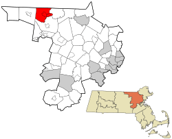
Location in Middlesex County in Massachusetts
|
|||
| Country | United States | ||
| State | Massachusetts | ||
| County | Middlesex | ||
| Settled | 1720 | ||
| Incorporated | 1775 | ||
| Named for | Sir William Pepperrell | ||
| Government | |||
| • Type | Open town meeting | ||
| Area | |||
| • Total | 23.2 sq mi (60.0 km2) | ||
| • Land | 22.6 sq mi (58.4 km2) | ||
| • Water | 0.6 sq mi (1.6 km2) | ||
| Elevation | 244 ft (74 m) | ||
| Population
(2020)
|
|||
| • Total | 11,604 | ||
| • Density | 500.2/sq mi (193.40/km2) | ||
| Time zone | UTC-5 (Eastern) | ||
| • Summer (DST) | UTC-4 (Eastern) | ||
| ZIP code |
01463
|
||
| Area code(s) | 351 / 978 | ||
| FIPS code | 25-52805 | ||
| GNIS feature ID | 0618231 | ||
| Website | town.pepperell.ma.us | ||
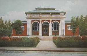
Pepperell is a town located in Middlesex County, Massachusetts, in the United States. In 2020, about 11,604 people lived here. The town includes a smaller area called East Pepperell. Pepperell is known for its historic town center, a special covered bridge, and the old Lawrence Library, which was built in 1901. The library even has a collection of stuffed birds by Sidney M. Shattuck!
Contents
History of Pepperell
Early Settlement and Name
Pepperell was first settled in 1720. At that time, it was part of a nearby town called Groton. In 1775, it officially became its own town. The town was named after Sir William Pepperrell. He was a soldier from Massachusetts who led an important battle during the French and Indian War. The area was known for its good soil and many orchards.
Role in the American Revolution
The people of Pepperell were very involved in the fight for American independence. Even though the British never attacked Pepperell directly, many men from the town fought in the Battle of Concord. This battle was a key moment in the American Revolutionary War.
A famous story from Pepperell involves a woman named Prudence Wright. She and other women captured a British spy near the Pepperell covered bridge! Also, a town resident named William Prescott was a commander at the Battle of Bunker Hill. This important battle took place in what is now Charlestown, a part of Boston.
Growth and Industry
By 1837, Pepperell had about 1,586 people. The town was home to three paper mills. These mills helped the town grow. People also made palm leaf hats, boots, and shoes here.
Railroad and Modern Changes
In 1848, a railroad line was built through East Pepperell. This connected the town to other places like Worcester and Portland. The railroad helped businesses in Pepperell, especially the paper mill. Over time, parts of the railroad were no longer used. In 2001, the old railroad path was turned into the Nashua River Rail Trail. This is now a popular place for biking, running, and walking.
Lawrence Library and Covered Bridge
The Lawrence Library in Pepperell was designed by famous architects and built in 1901. In 2009, the people of Pepperell voted to help fund the library, along with the Senior Center and Community Center. This vote helped keep these important places open.
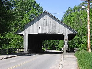
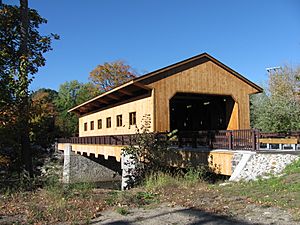
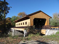
Pepperell is also home to a special covered bridge on Groton Street. It's one of only three covered bridges in Massachusetts that cars can still drive on! The current bridge opened in 2010, replacing an older one. It took two years to build this new bridge.
Geography of Pepperell
Pepperell covers about 23.2 square miles (60.0 square kilometers) of land and water. Most of this area, about 22.6 square miles (58.4 square kilometers), is land. The town is located where the Nissitissit River meets the Nashua River. Some people believe the town is built on an old volcano that is no longer active.
Neighboring Towns
Pepperell shares its borders with several other towns and cities:
- To the north: Brookline and Hollis, both in New Hampshire.
- To the east: Dunstable.
- To the south: Groton.
- To the west: Townsend.
- To the northeast: Nashua, New Hampshire, across the Nashua River.
Roads and Transportation
You can reach Pepperell using state roads like Route 111, Route 113, and Route 119.
Population and People
| Historical population | ||
|---|---|---|
| Year | Pop. | ±% |
| 1850 | 1,754 | — |
| 1860 | 1,895 | +8.0% |
| 1870 | 1,842 | −2.8% |
| 1880 | 2,348 | +27.5% |
| 1890 | 3,127 | +33.2% |
| 1900 | 3,701 | +18.4% |
| 1910 | 2,953 | −20.2% |
| 1920 | 2,468 | −16.4% |
| 1930 | 2,922 | +18.4% |
| 1940 | 3,114 | +6.6% |
| 1950 | 3,460 | +11.1% |
| 1960 | 4,336 | +25.3% |
| 1970 | 5,887 | +35.8% |
| 1980 | 8,061 | +36.9% |
| 1990 | 10,098 | +25.3% |
| 2000 | 11,142 | +10.3% |
| 2010 | 11,497 | +3.2% |
| 2020 | 11,604 | +0.9% |
| 2023* | 11,710 | +0.9% |
| * = population estimate. Source: United States Census records and Population Estimates Program data. |
||
In 2010, there were 11,497 people living in Pepperell. There were 3,847 households, and 3,016 families. About 44.2% of households had children under 18 living with them. The average household had about 2.89 people.
The population was spread out by age:
- 30.6% were under 18 years old.
- 6.1% were between 18 and 24.
- 33.0% were between 25 and 44.
- 22.7% were between 45 and 64.
- 7.5% were 65 years or older.
The average age in Pepperell was 35 years. The median income for a family in the town was about $97,870.
Education in Pepperell
Pepperell is part of the North Middlesex Regional School District. This district also includes the towns of Ashby and Townsend.
- Elementary school students attend Varnum Brook Elementary School.
- Middle school students go to Nissitissit Middle School.
- High school students attend North Middlesex Regional High School.
Fun Things to Do
- Nashua River Rail Trail: This is a great place for bicycling, running, and walking. It follows the path of an old railroad line.
Famous People from Pepperell
Many interesting people have come from Pepperell, including:
- Barbara Cooney: A famous writer and illustrator of children's books. She won the Caldecott Medal for her work.
- John Wesley Emerson: He founded the Emerson Electric Company.
- Herbert W. Levi: A professor and expert on spiders.
- Barzillai Lew: An African-American soldier who fought in the American Revolution.
- William Prescott: A colonel in the American Revolution who led forces at the Battle of Bunker Hill.
- Prudence Wright: A patriot who famously captured a British spy.
See also
 In Spanish: Pepperell (Massachusetts) para niños
 | William L. Dawson |
 | W. E. B. Du Bois |
 | Harry Belafonte |


