Brookline, New Hampshire facts for kids
Quick facts for kids
Brookline, New Hampshire
|
||
|---|---|---|
|
Town
|
||
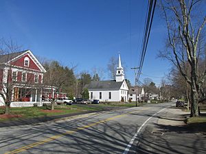
Main Street in Brookline
|
||
|
||
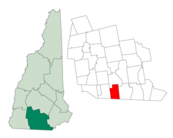
Location in Hillsborough County, New Hampshire
|
||
| Country | United States | |
| State | New Hampshire | |
| County | Hillsborough | |
| Incorporated | 1769 | |
| Villages |
|
|
| Area | ||
| • Total | 20.2 sq mi (52.3 km2) | |
| • Land | 19.8 sq mi (51.4 km2) | |
| • Water | 0.3 sq mi (0.9 km2) 1.79% | |
| Elevation | 256 ft (78 m) | |
| Population
(2020)
|
||
| • Total | 5,639 | |
| • Density | 284/sq mi (109.8/km2) | |
| Time zone | UTC-5 (Eastern) | |
| • Summer (DST) | UTC-4 (Eastern) | |
| ZIP code |
03033
|
|
| Area code(s) | 603 | |
| FIPS code | 33-08100 | |
| GNIS feature ID | 0873554 | |
Brookline is a small and friendly town in Hillsborough County, New Hampshire, United States. In 2020, about 5,639 people lived there. Brookline is a special place because it has the Talbot-Taylor Wildlife Sanctuary, a beautiful spot called Potanipo Pond, and the historic Brookline Covered Bridge. It's a great town for nature lovers!
Contents
History of Brookline
Brookline started as part of a larger area called Dunstable, Massachusetts. Later, it became known as West Hollis, New Hampshire. In 1769, it was officially given its own land and called "Raby." The name came from Colonial Governor John Wentworth. He named it after his cousin, who was the 4th Earl of Strafford and Baron of Raby Castle.
The town's name changed to Brookline in 1798. A local leader, who was originally from Brookline, Massachusetts, suggested the new name. Back in 1859, when about 718 people lived here, Brookline was busy! It had eight sawmills and a gristmill. There was also a shop that made sashes and blinds.
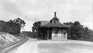
In its early days, Brookline was famous in southern New Hampshire for making lumber, charcoal, and casks (wooden barrels). The Boston and Maine Railroad even built a train line to Brookline in 1892. The old train station is now a private home. A lot of the land where the railroad tracks used to be is now New Hampshire Route 13.
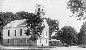
In 1997, the town got attention for a fun tradition. People would ring the Congregational church bell at midnight on the Fourth of July. This community event brought people together to celebrate.
Geography and Nature
Brookline covers about 52.3 square kilometers (20.2 square miles). Most of this area, about 51.4 square kilometers (19.8 square miles), is land. The rest, about 0.9 square kilometers (0.3 square miles), is water. Water makes up about 1.79% of the town.
The highest point in Brookline is the western part of Birch Hill. It stands about 810 feet (247 meters) above sea level. Another interesting spot is Potanipo Hill. This hill is about 613 feet (187 meters) high and is southwest of the town center. From 1935 to 1984, it was a ski area. Today, it is home to the Andres Institute of Art.
Two important waterways flow through Brookline: the Nissitissit River and Spaulding Brook. The Nissitissit River is about 10 miles (16 kilometers) long. It is well-known for having lots of trout. The Nissitissit River starts at Potanipo Pond, which is about half a mile (1 kilometer) west of the town center. It then flows southeast and joins the Nashua River in Pepperell, Massachusetts. All of Brookline's water eventually flows into the Merrimack River watershed.
The town is connected by two main roads: New Hampshire Route 13 and New Hampshire Route 130. Brookline is about 12 miles (19 kilometers) west of Nashua. It is also about 50 miles (80 kilometers) northwest of Boston, Massachusetts.
Neighboring Towns
Brookline shares its borders with several other towns:
- Milford (to the north)
- Hollis (to the east)
- Pepperell, Massachusetts (to the southeast)
- Townsend, Massachusetts (to the south)
- Mason (to the west)
Population Information
| Historical population | |||
|---|---|---|---|
| Census | Pop. | %± | |
| 1790 | 338 | — | |
| 1800 | 454 | 34.3% | |
| 1810 | 538 | 18.5% | |
| 1820 | 592 | 10.0% | |
| 1830 | 627 | 5.9% | |
| 1840 | 652 | 4.0% | |
| 1850 | 718 | 10.1% | |
| 1860 | 756 | 5.3% | |
| 1870 | 741 | −2.0% | |
| 1880 | 698 | −5.8% | |
| 1890 | 548 | −21.5% | |
| 1900 | 505 | −7.8% | |
| 1910 | 501 | −0.8% | |
| 1920 | 546 | 9.0% | |
| 1930 | 511 | −6.4% | |
| 1940 | 561 | 9.8% | |
| 1950 | 671 | 19.6% | |
| 1960 | 795 | 18.5% | |
| 1970 | 1,167 | 46.8% | |
| 1980 | 1,766 | 51.3% | |
| 1990 | 2,410 | 36.5% | |
| 2000 | 4,181 | 73.5% | |
| 2010 | 4,991 | 19.4% | |
| 2020 | 5,639 | 13.0% | |
| U.S. Decennial Census | |||
In 2000, there were 4,181 people living in Brookline. There were 1,343 households, and 1,146 of these were families. The town's population density was about 211.5 people per square mile (81.7 people per square kilometer). Most of the people living in Brookline were White (97.87%).
Many households (51.9%) had children under 18 living with them. About 76.7% of households were married couples living together. The average household had 3.11 people, and the average family had 3.36 people.
The population was quite young, with 33.6% of residents under 18 years old. About 35.7% were between 25 and 44 years old. The average age in town was 36 years. For every 100 females, there were about 102.8 males.
The median income for a household in Brookline was $77,075. For families, the median income was $80,214.
Education in Brookline
Brookline has a great school system for younger students.
- Richard Maghakian Memorial School teaches students from kindergarten to 3rd grade.
- Captain Samuel Douglass Academy is for children in grades 4 to 6.
Both schools work hard to give students a strong education. They focus on STEM (Science, Technology, Engineering, and Math) and the Arts.
Brookline also works with the nearby town of Hollis. They share a middle school and a high school for older students.
Economic Development
Brookline has a special group called the Economic Development Committee (EDC). This committee helps the town grow in a balanced way. They want to make sure new businesses fit well with the town's character. The EDC publishes a newsletter a few times a year. This newsletter helps promote local businesses in Brookline.
Community Events
Brookline hosts two fun community events each year:
- The winter Chowder/Soup/Chili Cook-Off is a tasty competition.
- The early-fall Bridal Show helps people plan weddings.
Hundreds of people from all over New England come to enjoy these events.
Town Newspaper
If you want to know what's happening in Brookline, you can read the Hollis Brookline Journal. It provides local news online.
Churches
In 1951, two churches in Brookline joined together. These were the Congregational church (started in 1795) and the Methodist church (started in 1852). This joining was led by Betty Hall, a local businesswoman. The new church was called the Church of Christ. In 2005, it was renamed the Brookline Community Church. It is connected to both the UCC and UMC groups.
Places to Visit
- Andres Institute of Art: A unique outdoor art museum.
- Brookline Covered Bridge: A historic and beautiful covered bridge.
- New Hampshire Historical Marker No. 271: Fresh Pond Ice Company: Learn about the town's past ice industry.
- Potanipo Hill: A hill that was once a ski area and now offers great views.
See also
 In Spanish: Brookline (Nuevo Hampshire) para niños
 | Selma Burke |
 | Pauline Powell Burns |
 | Frederick J. Brown |
 | Robert Blackburn |


