
Nashua, New Hampshire facts for kids
Quick facts for kids
Nashua, New Hampshire
|
|||
|---|---|---|---|
|
Downtown Nashua
St. Aloysius of Gonzaga Church
|
|||
|
|||
| Nickname(s):
New Hampshire's Gate City
|
|||

Location in Hillsborough County, New Hampshire
|
|||
| Country | |||
| State | |||
| County | Hillsborough | ||
| Settled | 1655 | ||
| Town | 1746 | ||
| City | 1853 | ||
| Area | |||
| • City | 31.73 sq mi (82.19 km2) | ||
| • Land | 30.83 sq mi (79.86 km2) | ||
| • Water | 0.90 sq mi (2.33 km2) 2.84% | ||
| Elevation | 151 ft (46 m) | ||
| Population
(2020)
|
|||
| • City | 91,322 | ||
| • Density | 2,961.73/sq mi (1,143.52/km2) | ||
| • Urban | 242,984 (US: 166th) | ||
| • Urban density | 1,242.5/sq mi (479.7/km2) | ||
| Demonym(s) | Nashuan | ||
| Time zone | UTC−5 (Eastern) | ||
| • Summer (DST) | UTC−4 (Eastern) | ||
| ZIP codes |
|
||
| Area code(s) | 603 | ||
| FIPS code | 33-50260 | ||
| GNIS feature ID | 0868677 | ||


Nashua (/ˈnæʃəwʌ/) is a city in southern New Hampshire, United States. It's the second-largest city in northern New England. As of 2020, about 91,322 people live there.
Nashua is one of two county seats for Hillsborough County. The other county seat is Manchester. The city is known as "New Hampshire's Gate City". This nickname means it's a key entry point between the Boston area and New Hampshire.
In the past, Nashua was famous for its textile (fabric) factories. Today, its economy focuses on financial services, high tech, and defense companies. Major employers include BAE Systems and Teradyne. The city also has two big hospitals: Southern New Hampshire Medical Center and St. Joseph Hospital.
The southern part of Nashua is a popular shopping spot. It's right on the Massachusetts border. People from Massachusetts like to shop here because New Hampshire doesn't have a sales tax. The main shopping area is around the Pheasant Lane Mall.
| Top - 0-9 A B C D E F G H I J K L M N O P Q R S T U V W X Y Z |
History of Nashua
The area where Nashua is located was first settled around 1654. It was part of a larger area in Massachusetts called "Dunstable". This area was important for fur trading. Nashua is roughly in the middle of the original land grant from 1673.
In 1741, the border between Massachusetts and New Hampshire was set. This split Dunstable into two parts. The northern part became Dunstable, New Hampshire, in 1746.
From Mills to Modern Tech
Like many towns in New England along rivers, Nashua grew during the Industrial Revolution. This was a time when factories used water power to make things. In 1823, the Nashua Manufacturing Company started. This company had four mills and employed about 1,000 people.
In 1836, the New Hampshire part of Dunstable was renamed "Nashua". It was named after the Nashua River. The Nashua River got its name from the Nashaway people. In their language, it means "beautiful stream with a pebbly bottom".
The city's textile mills did very well until about World War I. After that, they slowly declined. Newer energy sources like coal replaced water power. Also, cotton could be made into fabric closer to where it grew, saving money.
The textile business moved to the South during the Great Depression. The last mill near Nashua closed in 1949.
But Nashua's economy got a new start. A defense company called Sanders Associates moved into one of the old mills. This company is now part of BAE Systems. Sanders Associates also helped create the first home video game system, the Magnavox Odyssey.
In the 1970s, Digital Equipment Corp. (now part of Hewlett-Packard) arrived. This made Nashua a key part of the high-tech area around Boston.
-
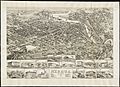
An 1883 drawing of Nashua from above
-
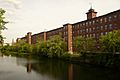
The historic Nashua Millyard
-
Canal St. Bridge, around 1908
-

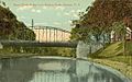
The Willows, around 1910; this road is now Route 101A
-
Hunt Memorial Library in 2006
.jpg)


Geography and Climate
Nashua is located in southeastern Hillsborough County. Its southern border is with Middlesex County, Massachusetts.
The city covers about 31.73 square miles (82.2 square kilometers). Most of this is land, with about 0.90 square miles (2.3 square kilometers) of water. The Merrimack River forms the eastern edge of Nashua. The city also has the Nashua River and Salmon Brook. The Nashua River cuts through the middle of the city.
The highest point in Nashua is Gilboa Hill. It is about 426 feet (130 meters) above sea level.

Nashua's Weather
Nashua has four distinct seasons. Summers are warm to hot and humid. Winters are cold and snowy. Spring and autumn are shorter transition seasons.
The average temperature in January is about 22.7°F (–5.2°C). In July, it's about 70.9°F (21.6°C). On average, there are about 9 days each year where the temperature reaches 90°F (32°C) or higher. There are also about 9 days where the temperature drops below 0°F (–18°C).
Nashua gets a good amount of rain throughout the year. Snowfall averages around 55 inches (140 cm) per winter. However, the amount of snow can change a lot from year to year. Nashua holds the New Hampshire state record for the highest temperature ever recorded: 106°F (41°C) during a heat wave in 1911.
| Climate data for Nashua, New Hampshire (1991–2020 normals, extremes 1885–present) | |||||||||||||
|---|---|---|---|---|---|---|---|---|---|---|---|---|---|
| Month | Jan | Feb | Mar | Apr | May | Jun | Jul | Aug | Sep | Oct | Nov | Dec | Year |
| Record high °F (°C) | 69 (21) |
76 (24) |
85 (29) |
93 (34) |
100 (38) |
100 (38) |
106 (41) |
105 (41) |
99 (37) |
91 (33) |
81 (27) |
73 (23) |
106 (41) |
| Mean maximum °F (°C) | 55.7 (13.2) |
57.2 (14.0) |
66.9 (19.4) |
81.0 (27.2) |
88.7 (31.5) |
92.1 (33.4) |
94.2 (34.6) |
92.0 (33.3) |
88.8 (31.6) |
78.9 (26.1) |
69.3 (20.7) |
59.1 (15.1) |
96.0 (35.6) |
| Mean daily maximum °F (°C) | 34.4 (1.3) |
37.4 (3.0) |
45.1 (7.3) |
58.5 (14.7) |
70.0 (21.1) |
78.4 (25.8) |
84.0 (28.9) |
82.6 (28.1) |
75.3 (24.1) |
62.8 (17.1) |
51.0 (10.6) |
40.0 (4.4) |
60.0 (15.6) |
| Daily mean °F (°C) | 24.1 (−4.4) |
26.1 (−3.3) |
34.3 (1.3) |
46.4 (8.0) |
58.0 (14.4) |
67.1 (19.5) |
72.7 (22.6) |
70.9 (21.6) |
63.3 (17.4) |
50.8 (10.4) |
40.2 (4.6) |
30.4 (−0.9) |
48.7 (9.3) |
| Mean daily minimum °F (°C) | 13.7 (−10.2) |
14.9 (−9.5) |
23.4 (−4.8) |
34.4 (1.3) |
46.0 (7.8) |
55.8 (13.2) |
61.4 (16.3) |
59.3 (15.2) |
51.2 (10.7) |
38.8 (3.8) |
29.5 (−1.4) |
20.8 (−6.2) |
37.4 (3.0) |
| Mean minimum °F (°C) | −4.7 (−20.4) |
−1.3 (−18.5) |
6.4 (−14.2) |
23.9 (−4.5) |
32.7 (0.4) |
42.4 (5.8) |
51.0 (10.6) |
48.2 (9.0) |
36.4 (2.4) |
26.3 (−3.2) |
16.5 (−8.6) |
4.6 (−15.2) |
−7.5 (−21.9) |
| Record low °F (°C) | −29 (−34) |
−35 (−37) |
−18 (−28) |
8 (−13) |
20 (−7) |
31 (−1) |
37 (3) |
31 (−1) |
23 (−5) |
12 (−11) |
−7 (−22) |
−24 (−31) |
−35 (−37) |
| Average precipitation inches (mm) | 3.44 (87) |
3.22 (82) |
4.31 (109) |
4.21 (107) |
3.90 (99) |
4.32 (110) |
3.65 (93) |
3.91 (99) |
4.05 (103) |
4.84 (123) |
3.88 (99) |
4.46 (113) |
48.19 (1,224) |
| Average snowfall inches (cm) | 14.7 (37) |
14.5 (37) |
10.1 (26) |
0.7 (1.8) |
0.0 (0.0) |
0.0 (0.0) |
0.0 (0.0) |
0.0 (0.0) |
0.0 (0.0) |
0.0 (0.0) |
1.7 (4.3) |
11.2 (28) |
52.9 (134) |
| Average precipitation days (≥ 0.01 in) | 9.2 | 8.4 | 9.2 | 10.8 | 12.1 | 10.9 | 10.4 | 9.3 | 9.2 | 10.8 | 10.0 | 10.1 | 120.4 |
| Average snowy days (≥ 0.1 in) | 5.4 | 4.8 | 3.4 | 0.5 | 0.0 | 0.0 | 0.0 | 0.0 | 0.0 | 0.1 | 0.8 | 3.9 | 18.9 |
| Source: NOAA | |||||||||||||
People of Nashua
| Historical population | |||
|---|---|---|---|
| Census | Pop. | %± | |
| 1790 | 632 | — | |
| 1800 | 862 | 36.4% | |
| 1810 | 1,049 | 21.7% | |
| 1820 | 1,142 | 8.9% | |
| 1830 | 2,417 | 111.6% | |
| 1840 | 6,054 | 150.5% | |
| 1850 | 5,820 | −3.9% | |
| 1860 | 10,065 | 72.9% | |
| 1870 | 10,543 | 4.7% | |
| 1880 | 13,397 | 27.1% | |
| 1890 | 19,311 | 44.1% | |
| 1900 | 23,898 | 23.8% | |
| 1910 | 26,005 | 8.8% | |
| 1920 | 28,379 | 9.1% | |
| 1930 | 31,463 | 10.9% | |
| 1940 | 32,927 | 4.7% | |
| 1950 | 34,669 | 5.3% | |
| 1960 | 39,096 | 12.8% | |
| 1970 | 55,820 | 42.8% | |
| 1980 | 67,865 | 21.6% | |
| 1990 | 79,662 | 17.4% | |
| 2000 | 86,605 | 8.7% | |
| 2010 | 86,494 | −0.1% | |
| 2020 | 91,322 | 5.6% | |
| U.S. Decennial Census | |||
In 2010, Nashua had 86,494 people. There were 35,044 households and 21,876 families. The city's population density was about 2,720 people per square mile.
About 83.4% of the people were White. About 2.7% were African American. About 6.5% were Asian. People of Hispanic or Latino background made up 9.8% of the population.
The median age in Nashua was 38.5 years old. About 22.1% of the population was under 18. About 12.7% were 65 or older. For every 100 females, there were about 97 males.
In 2011, the average income for a household was about $60,923. For a family, it was about $76,612. About 9.3% of the population lived below the poverty line. This included 11.4% of those under 18.
Nashua's Economy

Nashua has three main areas for businesses. Downtown Nashua is the oldest area. It has shops, restaurants, and entertainment. It's also near historic buildings. There are plans to make the Nashua River area downtown more friendly for walkers.
Amherst Street (Route 101A) is in the northwest part of the city. It's a busy road with many shopping centers. The South Nashua Commercial District is near the Massachusetts border. It has the Pheasant Lane Mall. Many people from Massachusetts come here to shop because New Hampshire does not have a sales tax.
Many technology companies are in Nashua. Nashua Corporation was a big maker of floppy disks. This made the Nashua name well known in the world of personal computers.
Other large tech companies include BAE Systems (a defense company) and Oracle Corporation (a software company). The Boston Air Route Traffic Control Center is also in Nashua. This center helps manage air traffic.
Sports and Fun

Nashua has a long history with baseball. The city's current team is the Nashua Silver Knights. They play in the Futures Collegiate Baseball League.
Before the Silver Knights, Nashua had other teams. These included the Nashua Pride and the Nashua Dodgers. The Nashua Dodgers were special because they were the first professional baseball team in the 20th century to have players of different races.
In college sports, Nashua is home to the Rivier University Raiders. They compete in the Great Northeast Athletic Conference.
The Spartans Drum and Bugle Corps is also based in Nashua. They have won several national championships.
Education in Nashua
In 2000, about a fourth of Nashua's residents over age three were in school. This shows how important education is in the city.
High Schools
- Nashua High School South
- Nashua High School North
- Brentwood Academy
- Clearway Alternative High School
- Bishop Guertin High School (a private Catholic school)
- Academy for Science and Design (a public charter school)
Middle Schools
- Brian S. McCarthy Middle School
- Fairgrounds Middle School
- Pennichuck Middle School
- Saint Christopher Academy (Upper Campus) (private)
- World Academy (private)
Elementary Schools
- Amherst Street Elementary School
- Bicentennial Elementary School
- Birch Hill Elementary School
- Broad Street Elementary School
- Charlotte Avenue Elementary School
- Dr. Norman W. Crisp Elementary School
- Fairgrounds Elementary School
- Ledge Street Elementary School
- Main Dunstable Elementary School
- Mount Pleasant Elementary School
- New Searles Elementary School
- Sunset Heights Elementary School
Colleges and Universities
- Nashua Community College (NCC)
- Granite State College (shares a campus with NCC)
- Rivier University
- Hellenic American University
Media and News
The local newspaper in Nashua is The Telegraph. It publishes news online every day and a printed edition once a week.
Nashua also has several radio stations. These include WGHM 900 AM (oldies music) and WSMN 1590 AM (talk radio). WFNQ 106.3 FM plays classic hits. You can also listen to New Hampshire Public Radio stations WEVS 88.3 and 90.3. Nashua can also pick up most radio stations from the Boston area.
One television station is licensed to Nashua, WBTS-CD (channel 15). It is owned by NBC and serves as the NBC station for the Boston area.
Getting Around Nashua
Roads and Highways
The Everett Turnpike is the main highway that goes through Nashua. U.S. Route 3 follows this turnpike. Other state highways in Nashua include NH 101A, NH 111, NH 111A, and NH 130.
In 2015, the city finished building the Broad Street Parkway. This road connects the Everett Turnpike to downtown Nashua. It helps reduce traffic and makes it easier to get to the old mill area. This project also added a third bridge over the Nashua River.
Public Transportation
The Nashua Transit System provides bus service within the city. It has nine bus routes. Boston Express offers a bus line from Nashua to Boston. This bus takes passengers to South Station and Logan International Airport in Boston.
Airport

Nashua Airport (Boire Field) is in the northwest part of the city. It's for smaller planes. For flights with airlines, people go to Manchester–Boston Regional Airport in Manchester or Logan International Airport in Boston.
Past and Future Rail Travel
In the past, Nashua was a center for trolley lines. You could take trolleys south to Boston or north to Manchester. The trolley system stopped running in 1932.
There are plans to bring back train service to Nashua. The idea is to extend the MBTA Commuter Rail's Lowell Line from Lowell to Manchester. This line would stop in Nashua. If built, Nashua would have two train stations: one near the Pheasant Lane Mall and one downtown.
Fire Department
The Nashua Fire Department has 176 full-time firefighters. They protect the city's 31.9 square miles and its population of over 91,000 people. The department has six fire stations. They use six engines, three ladder trucks, and other special vehicles. Nashua uses a private company for ambulance services.
Notable People from Nashua
Sister City
See also
 In Spanish: Nashua (Nuevo Hampshire) para niños
