
Milford, New Hampshire facts for kids
Quick facts for kids
Milford, New Hampshire
|
|||
|---|---|---|---|
|
Town
|
|||

The center oval and town hall
|
|||
|
|||

Location in Hillsborough County, New Hampshire
|
|||
| Country | United States | ||
| State | New Hampshire | ||
| County | Hillsborough | ||
| Incorporated | 1794 | ||
| Area | |||
| • Total | 25.47 sq mi (65.96 km2) | ||
| • Land | 25.41 sq mi (65.82 km2) | ||
| • Water | 0.05 sq mi (0.14 km2) 0.22% | ||
| Elevation | 259 ft (79 m) | ||
| Population
(2020)
|
|||
| • Total | 16,131 | ||
| • Density | 635/sq mi (245.1/km2) | ||
| Time zone | UTC-5 (Eastern) | ||
| • Summer (DST) | UTC-4 (Eastern) | ||
| ZIP code |
03055
|
||
| Area code(s) | 603 | ||
| FIPS code | 33-48020 | ||
| GNIS feature ID | 0873666 | ||


Milford is a town in Hillsborough County, New Hampshire, United States. It is located along the Souhegan River. In 2020, about 16,131 people lived there. This was an increase from 15,115 people in 2010. Milford is a main center for shopping and making things in the area known as the Souhegan Valley.
The town center is called the Milford census-designated place (CDP). About 9,212 people lived in the town center in 2020. It is found where New Hampshire routes 13 and 101A meet.
Contents
History of Milford
.jpg)
Milford became its own town in 1794. Before that, it was part of Amherst. The name "Milford" comes from a "mill" (a building that grinds grain) built near a "ford" (a shallow place to cross a river). This mill was built on the Souhegan River.
Milford was once famous for its many granite quarries. These quarries dug up granite stone. This stone was used to build important places. For example, the large pillars for the U.S. Treasury in Washington, D.C., were made from Milford granite. You can even see these pillars on the back of the American $10 bill! Because of this, Milford's nickname is "The Granite Town." Today, only one small quarry is still working.
Like many towns along rivers in New England, Milford had many busy textile mills in the 1800s. These mills made cloth and other fabric products. This industry moved away from New England by World War II. However, Milford is still an important place for businesses and shopping for the towns around it. Some big companies here include Hitchiner Manufacturing Co., which makes metal castings. Hendrix Wire and Cable Inc. makes metal cables. Cirtronics Corporation creates manufacturing solutions. In 2018, a local company called Alene Candles started a "conscious leadership" program. This was one of the first in the state for a factory setting.
Milford is also home to the Milford State Fish Hatchery. This is a place where fish are raised. The town also has the Souhegan Valley Boys & Girls Club. This club helps young people in the area.
Milford was a safe stop on the Underground Railroad. This was a secret network that helped enslaved people escape to freedom. It was also the home of Harriet E. Wilson. She wrote a book called Our Nig: Or, Sketches in the Life of a Free Black in 1859. This was the first novel by an African-American woman published in the United States.
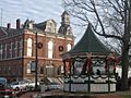
The center of town is called the Milford Oval. It is officially named "Union Square." Even though it's called a "square" or an "oval," it's actually shaped like a triangle! The name "square" often means a town common, no matter its shape. The "oval" name comes from the 1800s, when it used to be more oval-shaped. The Oval is the heart of the town. It has the Pillsbury Bandstand in the middle and the Souhegan River behind it. State Highways 13 and 101A meet at the Oval in a special way, like a traffic rotary.
-
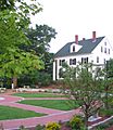
Centennial Park
-
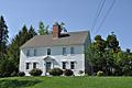
William Peabody House
-
Union Square c. 1905
-
Union Square in 2006
-
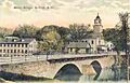
Stone Bridge c. 1905
-
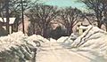
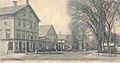
Elm Street c. 1915
-
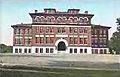
Centennial High School c. 1905


Geography and Climate
Milford's Location and Rivers
Milford covers about 66 square kilometers (25.5 square miles). Most of this area is land, with a small amount of water. The Souhegan River flows through Milford. This river flows east and joins the Merrimack River. Some parts of Milford are drained by Mitchell Brook and Spaulding Brook. These brooks flow south into Brookline and are part of the Nashua River watershed. The highest point in Milford is Boynton Hill. It is about 248 meters (814 feet) above sea level.
Neighboring Towns
Milford is next to several other towns:
- Lyndeborough (north)
- Mont Vernon (north)
- Amherst (east)
- Hollis (southeast)
- Brookline (south)
- Mason (southwest)
- Wilton (west)
Milford's Weather
Milford has a climate with hot summers and cold winters. This type of climate is called a "hot-summer humid continental climate." The hottest temperature ever recorded in Milford was 38 degrees Celsius (101 degrees Fahrenheit) in July 2011. The coldest temperature was -29 degrees Celsius (-21 degrees Fahrenheit) in January 1994.
| Climate data for Milford, New Hampshire, 1991–2020 normals, extremes 1950–present | |||||||||||||
|---|---|---|---|---|---|---|---|---|---|---|---|---|---|
| Month | Jan | Feb | Mar | Apr | May | Jun | Jul | Aug | Sep | Oct | Nov | Dec | Year |
| Record high °F (°C) | 69 (21) |
76 (24) |
88 (31) |
95 (35) |
95 (35) |
99 (37) |
101 (38) |
100 (38) |
96 (36) |
87 (31) |
77 (25) |
71 (22) |
101 (38) |
| Mean maximum °F (°C) | 54.6 (12.6) |
56.2 (13.4) |
66.2 (19.0) |
80.9 (27.2) |
88.3 (31.3) |
92.1 (33.4) |
93.4 (34.1) |
91.7 (33.2) |
87.7 (30.9) |
77.6 (25.3) |
68.0 (20.0) |
57.6 (14.2) |
95.2 (35.1) |
| Mean daily maximum °F (°C) | 33.2 (0.7) |
36.2 (2.3) |
44.6 (7.0) |
58.3 (14.6) |
69.2 (20.7) |
77.5 (25.3) |
83.4 (28.6) |
81.2 (27.3) |
72.7 (22.6) |
60.4 (15.8) |
48.9 (9.4) |
38.1 (3.4) |
58.6 (14.8) |
| Daily mean °F (°C) | 23.7 (−4.6) |
25.6 (−3.6) |
34.0 (1.1) |
46.3 (7.9) |
57.0 (13.9) |
66.1 (18.9) |
71.8 (22.1) |
69.4 (20.8) |
61.3 (16.3) |
49.0 (9.4) |
38.6 (3.7) |
29.1 (−1.6) |
47.7 (8.7) |
| Mean daily minimum °F (°C) | 14.3 (−9.8) |
14.9 (−9.5) |
23.5 (−4.7) |
34.3 (1.3) |
44.9 (7.2) |
54.8 (12.7) |
60.1 (15.6) |
57.6 (14.2) |
50.0 (10.0) |
37.7 (3.2) |
28.4 (−2.0) |
20.0 (−6.7) |
36.7 (2.6) |
| Mean minimum °F (°C) | −5.1 (−20.6) |
−2.6 (−19.2) |
4.4 (−15.3) |
22.3 (−5.4) |
31.8 (−0.1) |
41.9 (5.5) |
49.8 (9.9) |
46.6 (8.1) |
35.0 (1.7) |
24.7 (−4.1) |
15.0 (−9.4) |
3.4 (−15.9) |
−8.3 (−22.4) |
| Record low °F (°C) | −11 (−24) |
−16 (−27) |
−6 (−21) |
11 (−12) |
26 (−3) |
34 (1) |
43 (6) |
41 (5) |
25 (−4) |
17 (−8) |
7 (−14) |
−9 (−23) |
−16 (−27) |
| Average precipitation inches (mm) | 3.03 (77) |
2.99 (76) |
3.79 (96) |
4.15 (105) |
3.35 (85) |
4.03 (102) |
3.73 (95) |
3.68 (93) |
4.04 (103) |
4.88 (124) |
3.92 (100) |
4.45 (113) |
46.04 (1,169) |
| Average snowfall inches (cm) | 15.4 (39) |
11.5 (29) |
14.4 (37) |
2.3 (5.8) |
0.0 (0.0) |
0.0 (0.0) |
0.0 (0.0) |
0.0 (0.0) |
0.0 (0.0) |
0.1 (0.25) |
1.1 (2.8) |
12.6 (32) |
57.4 (145.85) |
| Average precipitation days (≥ 0.01 in) | 11.2 | 8.8 | 11.1 | 11.8 | 13.6 | 12.1 | 11.1 | 10.9 | 10.5 | 10.2 | 11.4 | 11.1 | 133.8 |
| Average snowy days (≥ 0.1 in) | 7.1 | 6.1 | 5.4 | 1.0 | 0.0 | 0.0 | 0.0 | 0.0 | 0.0 | 0.1 | 1.4 | 5.2 | 26.3 |
| Source 1: NOAA | |||||||||||||
| Source 2: National Weather Service | |||||||||||||
People of Milford
| Historical population | |||
|---|---|---|---|
| Census | Pop. | %± | |
| 1800 | 939 | — | |
| 1810 | 1,117 | 19.0% | |
| 1820 | 1,243 | 11.3% | |
| 1830 | 1,303 | 4.8% | |
| 1840 | 1,455 | 11.7% | |
| 1850 | 2,159 | 48.4% | |
| 1860 | 2,223 | 3.0% | |
| 1870 | 2,606 | 17.2% | |
| 1880 | 2,308 | −11.4% | |
| 1890 | 3,014 | 30.6% | |
| 1900 | 3,739 | 24.1% | |
| 1910 | 3,939 | 5.3% | |
| 1920 | 3,783 | −4.0% | |
| 1930 | 4,068 | 7.5% | |
| 1940 | 3,927 | −3.5% | |
| 1950 | 4,159 | 5.9% | |
| 1960 | 4,863 | 16.9% | |
| 1970 | 6,622 | 36.2% | |
| 1980 | 8,685 | 31.2% | |
| 1990 | 11,795 | 35.8% | |
| 2000 | 13,535 | 14.8% | |
| 2010 | 15,115 | 11.7% | |
| 2020 | 16,131 | 6.7% | |
| U.S. Decennial Census | |||
In 2010, there were 15,115 people living in Milford. There were 5,929 households, which are groups of people living together. About 4,004 of these were families. Most people in Milford were white (94.8%). A smaller number were African American (1.3%), Asian (1.3%), or Native American (0.2%). About 2.2% of the people were Hispanic or Latino.
In 2010, about 35.7% of households had children under 18 living there. More than half (52.0%) were married couples. About 10.5% had a female head of household with no husband. About 32.5% were not families. The average household had 2.53 people. The average family had 3.04 people.
About 25.0% of the people in Milford were under 18 years old. About 11.9% were 65 years or older. The average age was 39.0 years. For every 100 females, there were about 95.8 males.
From 2011 to 2015, the average yearly income for a household was about $64,576. For a family, it was about $80,241. The average income per person in the town was $32,918. A small number of people (5.8%) and families (3.7%) lived below the poverty line. This included 8.2% of people under 18 and 2.7% of those 65 or older.
Education in Milford

The Milford School District runs several schools. These include:
- Jacques Memorial School (for kindergarten and first grade)
- Heron Pond Elementary School (for grades 2-5)
- Milford Middle School (for grades 6-8)
- Milford High School & Applied Technology Center (for grades 9-12)
Culture and Events
Milford is well-known for its "Pumpkin Festival." This festival usually happens in early October. It lasts for three days, from Friday to Sunday. More than 35,000 people come to enjoy it! The festival has many fun things to do. You can find food vendors and listen to music on different stages. There's also a craft fair where artists sell their work. A special part of the festival is when carved pumpkins are lit up. There's also a haunted trail and a beer and wine tasting for adults. The festival ends with a fireworks show around the Oval.
Famous People from Milford
- John McLane (1852–1911): He was the 50th governor of New Hampshire from 1905 to 1907.
- Abby Hutchinson Patton (1829–1892): A singer and poet from the 1800s.
- George A. Ramsdell (1834–1900): He was the 46th governor of New Hampshire.
- Harriet E. Wilson (1825–1900): She is known as the first African-American woman to publish a novel in the United States.
See also
 In Spanish: Milford (Nuevo Hampshire) para niños
