Milford (CDP), New Hampshire facts for kids
Quick facts for kids
Milford, New Hampshire
|
|
|---|---|

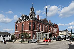
Milford Town Hall
|
|
| Country | United States |
| State | New Hampshire |
| County | Hillsborough |
| Town | Milford |
| Area | |
| • Total | 5.71 sq mi (14.79 km2) |
| • Land | 5.68 sq mi (14.72 km2) |
| • Water | 0.03 sq mi (0.07 km2) |
| Elevation | 263 ft (80 m) |
| Population
(2020)
|
|
| • Total | 9,212 |
| • Density | 1,621.26/sq mi (625.99/km2) |
| Time zone | UTC-5 (Eastern (EST)) |
| • Summer (DST) | UTC-4 (EDT) |
| ZIP code |
03055
|
| Area code(s) | 603 |
| FIPS code | 33-47940 |
| GNIS feature ID | 2378082 |
Milford is a special kind of community called a census-designated place (CDP). It is the main village in the larger town of Milford, which is located in Hillsborough County, New Hampshire, United States. In 2020, about 9,212 people lived in this specific area of Milford. The entire town of Milford had a population of 16,131 people.
Contents
Where is Milford?
The Milford CDP is located in the middle to northeastern part of the town of Milford. It sits on both sides of the Souhegan River. To the northeast, it borders the town of Amherst. Important roads like Ponemah Hill Road, Emerson Road, Armory Road, and Osgood Pond help define its southern edges. On the west, it reaches Whitten Road. North of the river, the border goes past Riverlea Road and Jennison Road before meeting the Amherst town line again.
Getting Around Milford
Several important roads pass through Milford. New Hampshire Route 101 is a major highway that goes through the southern part of the CDP. It can take you northeast about 19 miles (31 km) to Manchester or west about 17 miles (27 km) to Peterborough.
New Hampshire Route 13 goes right through the center of Milford, near the area known as the Milford Oval. This route leads north about 17 miles (27 km) to Goffstown and south about 24 miles (39 km) to Leominster, Massachusetts. Another road, New Hampshire Route 101A, leads southeast from Milford about 11 miles (18 km) to Nashua.
Land and Water
According to the U.S. Census Bureau, the Milford CDP covers a total area of about 5.71 square miles (14.8 square kilometers). A very small part of this area, about 0.03 square miles (0.07 square kilometers), is water. This means most of Milford is land.
How Many People Live Here?
| Historical population | |||
|---|---|---|---|
| Census | Pop. | %± | |
| 1950 | 3,269 | — | |
| 1960 | 3,916 | 19.8% | |
| 1970 | 4,997 | 27.6% | |
| 1980 | 6,269 | 25.5% | |
| 1990 | 8,015 | 27.9% | |
| 2000 | 8,293 | 3.5% | |
| 2010 | 8,835 | 6.5% | |
| 2020 | 9,212 | 4.3% | |
| U.S. Decennial Census | |||
The population of Milford has grown steadily over the years. Here's a look at how many people have lived in the CDP during different census years:
- 1950: 3,269 people
- 1960: 3,916 people
- 1970: 4,997 people
- 1980: 6,269 people
- 1990: 8,015 people
- 2000: 8,293 people
- 2010: 8,835 people
- 2020: 9,212 people
People and Households
In 2010, there were 8,835 people living in the Milford CDP. These people lived in 3,749 households. A household is a group of people living together in one home. Out of these, 2,271 were families.
Most people in Milford are white (94.4%). There are also smaller groups of African American (1.4%), Asian (1.4%), and Native American (0.3%) residents. About 2.5% of the population identified as Hispanic or Latino.
Age Groups
The people living in Milford come from all age groups.
- About 22.2% of residents were under 18 years old.
- 8.5% were between 18 and 24 years old.
- 28.1% were between 25 and 44 years old.
- 27.0% were between 45 and 64 years old.
- 14.1% were 65 years old or older.
The average age of people in Milford was about 39.1 years old.
See also
 In Spanish: Milford (condado de Hillsborough) para niños
 | Madam C. J. Walker |
 | Janet Emerson Bashen |
 | Annie Turnbo Malone |
 | Maggie L. Walker |


