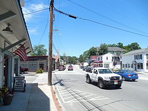
Goffstown (CDP), New Hampshire facts for kids
Quick facts for kids
Goffstown, New Hampshire
|
|
|---|---|

Main Street
|
|
| Country | United States |
| State | New Hampshire |
| County | Hillsborough |
| Town | Goffstown |
| Area | |
| • Total | 3.40 sq mi (8.81 km2) |
| • Land | 3.17 sq mi (8.20 km2) |
| • Water | 0.24 sq mi (0.61 km2) |
| Elevation | 315 ft (96 m) |
| Population
(2020)
|
|
| • Total | 3,366 |
| • Density | 1,062.84/sq mi (410.37/km2) |
| Time zone | UTC-5 (Eastern (EST)) |
| • Summer (DST) | UTC-4 (EDT) |
| ZIP code |
03045
|
| Area code(s) | 603 |
| FIPS code | 33-29780 |
| GNIS feature ID | 2629722 |
Goffstown is a community in New Hampshire, United States. It is called a census-designated place (CDP). This means it is a specific area that the government counts for population. It is the main village in the town of Goffstown. This area is located in Hillsborough County. In 2020, about 3,366 people lived in the Goffstown CDP. The entire town of Goffstown had a population of 18,577 people.
Contents
Geography
Where is Goffstown Located?
The Goffstown CDP is in the middle of the western part of the larger town of Goffstown. It sits on both sides of the Piscataquog River. The community stretches out in different directions. To the north, it goes past roads like Parsons Road and Winter Hill Road. To the east, it includes Upton Lane and Glen Lake. South of the CDP, you will find places like Goffstown High School. To the west, it extends beyond Cushing Road.
Roads and Travel
Several important roads go through the center of Goffstown. New Hampshire Route 114 is one of them. It goes southeast about 7 miles (11 km) to Bedford. It also goes northwest about 18 miles (29 km) to Henniker.
New Hampshire Route 13 also passes through the center. It joins Route 114 to cross the Piscataquog River. Route 13 leads north and east about 16 miles (26 km) to Concord. It also goes southwest about 7 miles (11 km) to New Boston. Downtown Manchester is about 8 miles (13 km) to the east.
Land and Water
The Goffstown CDP covers a total area of about 3.4 square miles (8.8 square kilometers). Most of this area is land, which is about 3.2 square miles (8.2 square kilometers). The rest is water, making up about 0.2 square miles (0.6 square kilometers). This means about 6.95% of the area is water.
Demographics
How Many People Live Here?
| Historical population | |||
|---|---|---|---|
| Census | Pop. | %± | |
| 1950 | 1,336 | — | |
| 1960 | 1,052 | −21.3% | |
| 1970 | 2,272 | 116.0% | |
| 2010 | 3,196 | — | |
| 2020 | 3,366 | 5.3% | |
| U.S. Decennial Census | |||
In 2010, there were 3,196 people living in the Goffstown CDP. These people lived in 1,269 households. A household is a group of people living together in one home. There were also 851 families.
Who Lives in Goffstown?
Most people in Goffstown are white, making up about 97.5% of the population in 2010. A small number of people were African American, Native American, or Asian. About 1.6% of the population identified as Hispanic or Latino.
Many households (32.2%) had children under 18 living with them. More than half of the households (53.3%) were married couples living together. About 26.3% of all households were made up of people living alone.
Age Groups
The median age in Goffstown in 2010 was 41.2 years old. This means half the people were younger than 41.2, and half were older.
- About 23.1% of residents were under 18 years old.
- About 7.7% were between 18 and 24 years old.
- About 24.6% were between 25 and 44 years old.
- About 31.4% were between 45 and 64 years old.
- About 13.3% were 65 years or older.
For every 100 females, there were about 97.6 males.
See also
 In Spanish: Goffstown (condado de Hillsborough) para niños
 | DeHart Hubbard |
 | Wilma Rudolph |
 | Jesse Owens |
 | Jackie Joyner-Kersee |
 | Major Taylor |


