
Amherst, New Hampshire facts for kids
Quick facts for kids
Amherst, New Hampshire
|
||
|---|---|---|
|
Town
|
||

Amherst Town Common in 2006
|
||
|
||

Location in Hillsborough County, New Hampshire
|
||

Amherst, New Hampshire
Location in New Hampshire

Amherst, New Hampshire
Location in the United States
|
||
| Country | United States | |
| State | New Hampshire | |
| County | Hillsborough | |
| Incorporated | 1760 | |
| Area | ||
| • Total | 34.4 sq mi (89.1 km2) | |
| • Land | 33.9 sq mi (87.8 km2) | |
| • Water | 0.5 sq mi (1.3 km2) 1.49% | |
| Elevation | 259 ft (79 m) | |
| Population
(2020)
|
||
| • Total | 11,753 | |
| • Density | 347/sq mi (133.8/km2) | |
| Time zone | UTC−5 (Eastern) | |
| • Summer (DST) | UTC−4 (Eastern) | |
| ZIP code |
03031
|
|
| Area code | 603 | |
| FIPS code | 33-01300 | |
| GNIS feature ID | 0873531 | |

Amherst is a town in Hillsborough County, New Hampshire, United States. In 2020, about 11,753 people lived there. Amherst is known for its beautiful natural areas like Ponemah Bog Wildlife Sanctuary, Hodgman State Forest, the Joe English Reservation, and Baboosic Lake.
The main village of Amherst is a smaller area within the town. About 697 people lived there in 2020. This village is special because it's listed on the National Register of Historic Places. This means it has important old buildings and history.
Contents
History of Amherst
How Amherst Started
Amherst, like many towns in New England, began with a special gift of land. This land was given to soldiers who fought in a war called King Philip's War in 1728. Five years later, in 1733, people started to settle there. They first called it "Narragansett Number 3" and then "Souhegan Number 3."
In 1741, the settlers built a church and hired a minister. On January 18, 1760, the governor of New Hampshire, Benning Wentworth, officially made it a town. He named it after General Jeffery Amherst, a famous leader during the French and Indian War.
Growth and Changes
In 1770, Amherst became the most important town in Hillsborough County. This was because it was located on a major road. The town continued to grow during and after the American Revolutionary War.
However, some parts of Amherst later became separate towns. In 1790, the southwestern part became Milford. In 1803, the northwest part became Mont Vernon. Milford grew a lot because it had water-powered mills. Because of this, the county's main office moved from Amherst to Milford in 1866.
Amherst's population stayed about the same for a long time. But after World War II, many new people moved to Amherst. The town became a part of the larger Greater Boston area.
Famous Connections
Franklin Pierce, who later became the 14th President of the United States, studied in Amherst. He married Jane Means Appleton in a house on the town green. Her father was a former president of Bowdoin College.
The Nashua and Wilton Railroad also passed through Amherst, which helped connect the town to other places.
Geography of Amherst
Amherst covers about 89.1 square kilometers (34.4 square miles). Most of this is land (87.8 square kilometers or 33.9 square miles). A small part, about 1.3 square kilometers (0.5 square miles), is water.
Waterways and Land Features
All of Amherst is part of the Merrimack River watershed. This means that all the rain and water in Amherst eventually flows into the Merrimack River. The Souhegan River flows through the southern part of town. Beaver Brook, which flows through the main village, also feeds into the Souhegan River.
Baboosic Lake is located along the eastern edge of the town. Joe English Brook feeds this lake. The highest point in Amherst is on Chestnut Hill, which is about 264 meters (865 feet) above sea level.
Roads and Nearby Towns
New Hampshire Route 101 goes through Amherst. It connects the town to Bedford and Manchester to the northeast, and Milford to the southwest. Another road, New Hampshire Route 101A, goes through the southern part of Amherst. It links Milford to the west with Nashua to the southeast. New Hampshire Route 122 starts in Amherst village and goes south to Hollis.
Adjacent municipalities
Amherst is next to several other towns:
- Bedford, New Hampshire (northeast)
- Merrimack, New Hampshire (east)
- Hollis, New Hampshire (south)
- Milford, New Hampshire (southwest)
- Mont Vernon, New Hampshire (west)
- New Boston, New Hampshire (northwest)
Population of Amherst
| Historical population | |||
|---|---|---|---|
| Census | Pop. | %± | |
| 1790 | 2,369 | — | |
| 1800 | 1,470 | −37.9% | |
| 1810 | 1,554 | 5.7% | |
| 1820 | 1,622 | 4.4% | |
| 1830 | 1,657 | 2.2% | |
| 1840 | 1,565 | −5.6% | |
| 1850 | 1,613 | 3.1% | |
| 1860 | 1,598 | −0.9% | |
| 1870 | 1,353 | −15.3% | |
| 1880 | 1,225 | −9.5% | |
| 1890 | 1,053 | −14.0% | |
| 1900 | 1,231 | 16.9% | |
| 1910 | 1,060 | −13.9% | |
| 1920 | 868 | −18.1% | |
| 1930 | 1,115 | 28.5% | |
| 1940 | 1,174 | 5.3% | |
| 1950 | 1,461 | 24.4% | |
| 1960 | 2,051 | 40.4% | |
| 1970 | 4,605 | 124.5% | |
| 1980 | 8,243 | 79.0% | |
| 1990 | 9,068 | 10.0% | |
| 2000 | 10,769 | 18.8% | |
| 2010 | 11,201 | 4.0% | |
| 2020 | 11,753 | 4.9% | |
| U.S. Decennial Census | |||
In 2010, there were 11,201 people living in Amherst. There were 4,063 households, and 3,322 families. About 37.7% of households had children under 18. Most households (72.2%) were married couples living together.
The average household had 2.76 people, and the average family had 3.06 people. The population's age spread was:
- 26.0% were under 18
- 5.6% were 18 to 24
- 19.4% were 25 to 44
- 36.5% were 45 to 64
- 12.5% were 65 or older
The average age in Amherst was 44.4 years.
Public education in Amherst
Amherst has several schools for its students. Clark and Wilkins are elementary schools for younger children from Amherst. Students from Amherst and nearby Mont Vernon attend Amherst Middle School for seventh and eighth grades. Both towns also share Souhegan High School.
Notable people
- Charles G. Atherton (1804–1853), U.S. congressman and senator
- Charles Humphrey Atherton (1773–1853), U.S. congressman
- Courtney Banghart (born 1978), head women's basketball coach at North Carolina. (Souhegan High School, 1996)
- John S. Barry (1802–1870), fourth and eighth Governor of Michigan
- Samuel Bell (1770–1850), 14th Governor of New Hampshire
- Moses Billings (1809–1884), portrait artist
- Hubert Buchanan (born 1941), prisoner of war in Vietnam
- Clifton Clagett (1762–1829), U.S. congressman
- Jonathan Fisk (1778–1832), U.S. congressman from New York
- Horace Greeley (1811–1872), editor, founder of the Liberal Republican Party
- Jon "maddog" Hall (born 1950), programmer, computer scientist, free software advocate
- Joanne Head (1930–2021), member of the New Hampshire House of Representatives
- Neal Huntington (born 1969), General Manager of the Pittsburgh Pirates (2007–present)
- Tony Labranche (born 2001), youngest member of the New Hampshire House of Representatives as of 2021
- Moses Nichols (1740–1790), physician, Revolutionary War era soldier and statesman
- Jane Means (Appleton) Pierce (1806–1863), first lady, wife of Franklin Pierce
- Frank Selee (1859–1909), manager for the Boston Beaneaters and Chicago Orphans, member of Baseball Hall of Fame
Images for kids
-
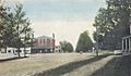
A photograph of Amherst taken in 1910
-
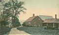
Horace Greeley's birthplace around 1905


See also
 In Spanish: Amherst (Nuevo Hampshire) para niños
