
Mont Vernon, New Hampshire facts for kids
Quick facts for kids
Mont Vernon, New Hampshire
|
|
|---|---|
|
Town
|
|

Town hall
|
|

Location in Hillsborough County, New Hampshire
|
|
| Country | United States |
| State | New Hampshire |
| County | Hillsborough |
| Incorporated | 1803 |
| Area | |
| • Total | 16.9 sq mi (43.8 km2) |
| • Land | 16.8 sq mi (43.6 km2) |
| • Water | 0.08 sq mi (0.2 km2) 0.49% |
| Elevation | 820 ft (250 m) |
| Population
(2020)
|
|
| • Total | 2,584 |
| • Density | 154/sq mi (59.3/km2) |
| Time zone | UTC-5 (Eastern) |
| • Summer (DST) | UTC-4 (Eastern) |
| ZIP code |
03057
|
| Area code(s) | 603 |
| FIPS code | 33-49140 |
| GNIS feature ID | 0873670 |
Mont Vernon is a small town located in Hillsborough County, New Hampshire, in the United States. In 2020, about 2,584 people lived there. This was a bit more than the 2,409 people counted in 2010.
Contents
Why the Name "Mont Vernon" is Different
You might wonder why Mont Vernon is spelled without a "u," unlike other places named after Mount Vernon, George Washington's home. The town's original charter from 1803 spelled it this way.
Later, in the late 1800s, a local hotel owner tried to add the "u" back. He hoped it would attract more visitors. But after he passed away, the spelling went back to "Mont Vernon."
Mont Vernon's History
Mont Vernon became its own town in 1803. Before that, it was part of Amherst. They separated after a disagreement about the town's church district. Later, a small piece of Lyndeborough was added to Mont Vernon.
From Farms to Tourist Spot
Like many towns in the area, Mont Vernon started as a farming community. But after the Civil War, things changed. New railroads made it easier to farm in the Midwest, which hurt local farms. Mont Vernon's population was highest in 1870, then it started to shrink.
By the late 1890s, Mont Vernon became a popular place for tourists. People from cities like Boston came to escape the summer heat. The town had five big hotels, including the Grand Hotel, and many smaller places to stay.
The End of the Hotel Era
The hotel business started to decline when cars became popular. Cars allowed people to travel further, like to the White Mountains. The Great Depression in the 1930s completely ended the hotel era. By World War II, all the hotels were gone, either torn down or destroyed by fire. The town's population dropped to only about 300 people by 1930.
Becoming a Suburban Town
After World War II, Mont Vernon slowly grew into a suburban town. This growth sped up in the early 1960s. Many engineers and technicians working at Sanders Associates in Nashua found homes in Mont Vernon appealing. By the 1970s, the town's population was higher than it had ever been.
Farming, including a big chicken and egg farming period in the 1940s and 1950s, has mostly disappeared. Today, Mont Vernon has only one dairy farm. The town also has a general store that has been open for over 120 years in the same spot, except for a short break.
In 2012, Mont Vernon was in the news because of a debate about renaming a small fishing spot. The town decided to rename it Carleton Pond, after the family who gave the land to the town.
-
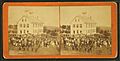
The Appleton Academy (now McCollom Building) c. 1875
-
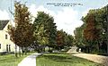
North from Town Hall c. 1915
-
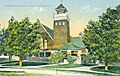
Congregational Church c. 1910
-
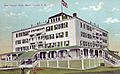
The Grand Hotel in 1909


Mont Vernon's Geography
Mont Vernon covers about 43.8 square kilometers (about 16.9 square miles). Most of this is land, with a small amount of water. Rivers and streams like Beaver Brook, Hartshorn Brook, and Purgatory Brook flow through the town. These streams eventually join the Souhegan River. The town's highest point is about 1015 feet (309 meters) above sea level, near Storey Hill.
New Hampshire Route 13 is the main state highway that goes through Mont Vernon. It connects the town to Milford in the south and New Boston in the north.
Neighboring Towns
- New Boston (north)
- Amherst (east)
- Milford (south)
- Lyndeborough (west)
Population Information
| Historical population | |||
|---|---|---|---|
| Census | Pop. | %± | |
| 1800 | 680 | — | |
| 1810 | 762 | 12.1% | |
| 1820 | 729 | −4.3% | |
| 1830 | 763 | 4.7% | |
| 1840 | 720 | −5.6% | |
| 1850 | 722 | 0.3% | |
| 1860 | 725 | 0.4% | |
| 1870 | 601 | −17.1% | |
| 1880 | 517 | −14.0% | |
| 1890 | 479 | −7.4% | |
| 1900 | 453 | −5.4% | |
| 1910 | 413 | −8.8% | |
| 1920 | 308 | −25.4% | |
| 1930 | 302 | −1.9% | |
| 1940 | 340 | 12.6% | |
| 1950 | 405 | 19.1% | |
| 1960 | 585 | 44.4% | |
| 1970 | 906 | 54.9% | |
| 1980 | 1,444 | 59.4% | |
| 1990 | 1,812 | 25.5% | |
| 2000 | 2,034 | 12.3% | |
| 2010 | 2,409 | 18.4% | |
| 2020 | 2,584 | 7.3% | |
| U.S. Decennial Census | |||
In 2020, Mont Vernon had 2,584 people living in 945 households. About 30.9% of these households had children under 18. The population is made up of people from various backgrounds. The median age in town was about 45.5 years old.
Schools in Mont Vernon
Mont Vernon has one public school called the Mont Vernon Village School. It teaches students from kindergarten through sixth grade. For seventh and eighth grades, students go to Amherst Middle School in Amherst. High school students (grades 9-12) attend Souhegan High School, which is also in Amherst but is shared by both Mont Vernon and Amherst.
Mont Vernon also had private schools in the past. One was the Appleton Academy, which later became the McCollom Institute. Another was the Stearns School. These schools closed down, especially during the Great Depression. Today, the old McCollom building is used for the police department and town offices.
Mont Vernon Fire Department
The Mont Vernon Fire Station was built in 1947. In 2007, the town decided to replace the old building with a new one on the same spot. The new station has space for fire trucks and offices for the Fire Chief and Emergency Management Director. Emergency medical services for Mont Vernon are provided by the town of Amherst.
Town Culture and Events

Mont Vernon has two main yearly celebrations:
- Lamson Farm Day: This event happens on the last Saturday in September. It's held at a town-owned farm and celebrates Mont Vernon's farming history.
- Mont Vernon Spring Gala: This celebration takes place in late April or early May. It's a way to welcome spring.
Both events feature fun games, tasty food, and local performers.
Sports and Recreation
Mont Vernon has two regional sports teams for girls aged 9–12: the Mont Vernon Falcons basketball team and the Mont Vernon Acers volleyball team. The Mont Vernon Village School has courts for both basketball and volleyball. Adults also play volleyball there on Monday nights.
The town has a baseball field with bases, fencing, and dugouts near the school. This field is also used for other sports. In the early 1900s, people even played golf behind where the post office is now.
Mont Vernon has a gun range called the Purgatory Falls Fish & Game Club. There used to be a ski hill with a rope tow, but it closed in the mid-1900s. The town is known for its beautiful views of the Souhegan Valley. There are also many hiking trails, especially at Lamson Farm and along Purgatory Brook. The Morrissette Trail, opened in 2012, offers a hike from the lowest to the highest points in Mont Vernon.
Famous People from Mont Vernon
- Doc Adams (1814–1899): A pioneer in baseball, who played for and managed the New York Knickerbockers.
- George Wilkins Kendall (1809–1867): A journalist who reported on the Mexican-American War and started The New Orleans Picayune newspaper.
- Erland Van Lidth De Jeude (1983–1987): An actor and amateur wrestler.
- Ryan M. Pitts (born 1985): A recipient of the Congressional Medal of Honor.
- Alex Preston (born 1993): A musician who was a top 3 finalist on American Idol (season 13).
See also
 In Spanish: Mont Vernon (Nuevo Hampshire) para niños
