Lyndeborough, New Hampshire facts for kids
Quick facts for kids
Lyndeborough, New Hampshire
|
||
|---|---|---|
|
Town
|
||

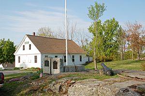
1846 Town Hall
|
||
|
||

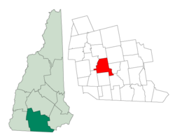
Location in Hillsborough County, New Hampshire
|
||
| Country | United States | |
| State | New Hampshire | |
| County | Hillsborough | |
| Incorporated | 1764 | |
| Villages |
|
|
| Area | ||
| • Total | 30.5 sq mi (79.1 km2) | |
| • Land | 30.4 sq mi (78.8 km2) | |
| • Water | 0.1 sq mi (0.3 km2) 0.38% | |
| Elevation | 883 ft (269 m) | |
| Population
(2020)
|
||
| • Total | 1,702 | |
| • Density | 56/sq mi (21.6/km2) | |
| Time zone | UTC-5 (Eastern) | |
| • Summer (DST) | UTC-4 (Eastern) | |
| ZIP code |
03082
|
|
| Area code(s) | 603 | |
| FIPS code | 33-44580 | |
| GNIS feature ID | 0873655 | |
Lyndeborough is a small town in Hillsborough County, New Hampshire, United States. In 2020, about 1,702 people lived there.
Contents
History of Lyndeborough
Lyndeborough was first given to soldiers from Salem, Massachusetts, who fought in a war against Canada. Because of this, the area was first known as "Salem-Canada."
Early Settlers and New Name
The first settlers were John Cram and his family. They arrived in 1736 and built a sawmill. The town later got its current name, "Lyndeborough." This name came from a group of owners that included Benjamin Lynde. He was a very important judge in Massachusetts.
Important Landmarks and Groups
Since 1833, the Lafayette Artillery Company has been based in Lyndeborough. This group was started in 1804. The town has several historic buildings. Citizens' Hall, which opened in 1889, is listed on the National Register of Historic Places. The Lyndeborough Center Historic District is also on this list. It includes the old Congregational church (built around 1836), the town hall (built in 1846), and parts of the old town animal pound (from 1774).
Geography of Lyndeborough
Lyndeborough covers about 79.1 square kilometers (about 30.5 square miles). Most of this area is land, with a small amount of water. Rivers and streams like Stony Brook and Curtis Brook flow through the town. These waters eventually join the Merrimack River.
Mountains and Roads
The highest point in Lyndeborough is almost 549 meters (1,800 feet) above sea level. This spot is on the east side of North Pack Monadnock Mountain. Other notable mountains in town include Winn Mountain, Rose Mountain, and The Pinnacle. New Hampshire Route 31 is a main road that goes through Lyndeborough. It connects the town to Greenfield in the northwest and Wilton in the southeast.
Neighboring Towns
Lyndeborough shares its borders with several other towns:
- Francestown (to the north)
- New Boston (to the northeast)
- Mont Vernon (to the east)
- Milford (to the southeast)
- Wilton (to the south)
- Temple (to the southwest)
- Greenfield (to the west)
Population Changes in Lyndeborough
Lyndeborough's population has changed quite a bit over the years. In 1790, there were 1,280 people living here. The population went down for a while, reaching a low of 399 people in 1930. Since then, it has grown steadily. By 2020, the population was 1,702.
Who Lives in Lyndeborough?
In 2000, there were 1,585 people living in Lyndeborough. About 27% of the people were under 18 years old. The average age was 38 years old. Most households were families, with many married couples living together.
Famous People from Lyndeborough
Some notable people have come from Lyndeborough:
- William Barron (1787–1872), who was a United States Marshal.
- Eddie Mottau, a talented guitarist.
- Willard Parker (1800–1884), a pioneering surgeon.
Places to Visit in Lyndeborough
If you visit Lyndeborough, you might want to see these interesting places:
- Citizens' Hall
- Hartshorn Memorial Cannon
- Lafayette Artillery Company
- Lyndeborough Center Historic District
See also
 In Spanish: Lyndeborough para niños
 | Mary Eliza Mahoney |
 | Susie King Taylor |
 | Ida Gray |
 | Eliza Ann Grier |


