
Wilton, New Hampshire facts for kids
Quick facts for kids
Wilton, New Hampshire
|
||
|---|---|---|
|
Town
|
||

Stony Brook near the town center
|
||
|
||

Location in Hillsborough County, New Hampshire
|
||
| Country | United States | |
| State | New Hampshire | |
| County | Hillsborough | |
| Incorporated | 1762 | |
| Villages |
|
|
| Area | ||
| • Total | 25.70 sq mi (66.57 km2) | |
| • Land | 25.61 sq mi (66.33 km2) | |
| • Water | 0.09 sq mi (0.23 km2) 0.35% | |
| Elevation | 384 ft (117 m) | |
| Population
(2020)
|
||
| • Total | 3,896 | |
| • Density | 152/sq mi (58.7/km2) | |
| Time zone | UTC-5 (Eastern) | |
| • Summer (DST) | UTC-4 (Eastern) | |
| ZIP code |
03086
|
|
| Area code(s) | 603 | |
| FIPS code | 33-85220 | |
| GNIS feature ID | 0873756 | |

Wilton is a town in Hillsborough County, New Hampshire, in the United States. In 2020, about 3,896 people lived there.
Like many towns in New England, Wilton started with mills powered by water. These mills made things like cloth. Today, Wilton is a quiet town where many people live and travel to work in bigger cities. It also has some factories and service jobs. Wilton is home to the High Mowing School, which is a private school.
The main part of Wilton is called the Wilton census-designated place. In 2020, 1,324 people lived there. This area is where two rivers, Stony Brook and the Souhegan River, meet. It's also near the crossing of New Hampshire Routes 31 and 101.
Contents
History of Wilton
Early Beginnings
Wilton was first part of a larger area called "Salem-Canada." This area was set up in 1735 by Governor Jonathan Belcher of Massachusetts. At that time, Massachusetts claimed this land. It was given to soldiers from Salem, Massachusetts, who had fought in a war against Canada in 1690. "Salem-Canada" was one of the towns on the border. It was meant to help protect against attacks from Native American groups.
In 1749, the area was given out again by New Hampshire's Governor Benning Wentworth. It was called "Number Two." Then, in 1762, it officially became a town named "Wilton." The town might have been named after Wilton in England. Or, it could have been named after Sir Joseph Wilton, a famous English sculptor. Sir Wilton designed a special coach for King George III's coronation. This design was later used as a model for the famous Concord coach. Later, the town of Wilton, Maine, was named after Wilton, New Hampshire.
First Sunday School
The first Sunday school in Wilton started in May 1816. It was connected to the Congregational church. The school was held in the Centre schoolhouse. Two women, Phebe Abbot and Sarah White Livermore, were important leaders in starting this school. This Sunday school was one of the very first in the U.S. to focus only on religious teaching. Seventy children attended the first time. The only book they used was the Bible.
Wilton's Rivers and Mills
The Souhegan River was very important for Wilton's early growth. It provided water power for many mills. Today, Wilton is a rural town. You can find orchards, farms, and woodlands there.
Geography of Wilton

Wilton covers about 66.6 square kilometers (25.7 square miles). Most of this area, about 66.3 square kilometers (25.6 square miles), is land. Only a small part, about 0.2 square kilometers (0.1 square miles), is water. This means about 0.35% of the town is water.
The town gets its water from the Souhegan River and its smaller streams. These streams include Stony Brook and Blood Brook. All the water from Wilton eventually flows into the Merrimack River. The highest point in Wilton is about 347 meters (1,140 feet) above sea level. This spot is on the east side of Fisk Hill, near the town's western border.
Neighboring Towns
Wilton shares its borders with several other towns:
- Lyndeborough (to the north)
- Milford (to the east)
- Mason (to the south)
- Greenville (to the southwest)
- Temple (to the west)
People of Wilton
| Historical population | |||
|---|---|---|---|
| Census | Pop. | %± | |
| 1790 | 1,105 | — | |
| 1800 | 1,010 | −8.6% | |
| 1810 | 1,017 | 0.7% | |
| 1820 | 1,070 | 5.2% | |
| 1830 | 1,041 | −2.7% | |
| 1840 | 1,033 | −0.8% | |
| 1850 | 1,161 | 12.4% | |
| 1860 | 1,369 | 17.9% | |
| 1870 | 1,974 | 44.2% | |
| 1880 | 1,747 | −11.5% | |
| 1890 | 1,850 | 5.9% | |
| 1900 | 1,696 | −8.3% | |
| 1910 | 1,490 | −12.1% | |
| 1920 | 1,546 | 3.8% | |
| 1930 | 1,724 | 11.5% | |
| 1940 | 1,855 | 7.6% | |
| 1950 | 1,952 | 5.2% | |
| 1960 | 2,025 | 3.7% | |
| 1970 | 2,276 | 12.4% | |
| 1980 | 2,669 | 17.3% | |
| 1990 | 3,122 | 17.0% | |
| 2000 | 3,743 | 19.9% | |
| 2010 | 3,677 | −1.8% | |
| 2020 | 3,896 | 6.0% | |
| U.S. Decennial Census | |||
In 2010, there were 3,677 people living in Wilton. There were 1,418 households and 1,015 families. Most people in Wilton (97.1%) were White. About 0.5% were African American, and 0.2% were Native American. About 1.4% of the population was Hispanic or Latino.
About 33.1% of households had children under 18. Most households (56.8%) were married couples living together. The average household had 2.59 people. The average family had 3.02 people.
About 23.5% of Wilton's population was under 18. About 11.9% were 65 or older. The average age in town was 42.1 years.
Places to Visit in Wilton
- Russell-Abbott State Forest: Part of this forest is in Wilton. It's named after two of Wilton's very first families.
- Andy's Summer Playhouse: This is a children's theater. It brings visitors from all over the area.
- Frye's Measure Mill: This old mill is 150 years old. It's about three miles west of downtown Wilton. You can take tours there.
- Wilton Town Hall Theatre: This is a movie theater that shows art-house films. It's located in the Town Hall's main room.
- Souhegan Mills: These mills are a well-known part of Wilton's town center. They have been used for many things. These include packing apples, processing materials, and even making ammunition boxes during World War II. Today, Souhegan Mills is home to Souhegan Wood Products. This company makes and sells products from recycled wood.
- Oliver Whiting Homestead: This is a historic farm on Old County Farm Road.
Famous People from Wilton
,_1846-1899.jpg)
- Charles Greeley Abbot (1872–1973), a scientist who studied stars and space.
- John Putnam Batchelder (1784–1868), a surgeon and expert in anatomy.
- Frank Gay Clarke (1850–1901), a member of Congress.
- Snatam Kaur (1972–), an American singer, songwriter, and author.
- Sarah White Livermore (1789–1874), a teacher and writer.
- Rod Price (1947–2005), a guitarist and recording artist for the blues/rock band "Foghat."
- Annie R. Smith (1828–1855), an early Seventh-day Adventist hymn writer.
- Uriah Smith (1832–1903), a Seventh-day Adventist author, minister, and educator. He was the editor of the Review and Herald (now the Adventist Review) for over 50 years.
- William French Smith (1917–1990), the 74th United States Attorney General.
Images for kids
-
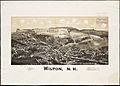
Wilton in 1880
-
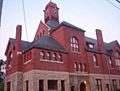
Town Hall
-
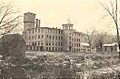
Wilton Woolen Co. mill in 1912
-
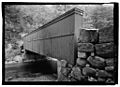
Livermore Bridge over Blood Brook
-
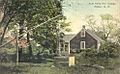
Aunt Mary Ann Cottage c. 1915
.jpg)


See also
 In Spanish: Wilton (Nuevo Hampshire) para niños
