
Greenville, New Hampshire facts for kids
Quick facts for kids
Greenville, New Hampshire
|
|
|---|---|
|
Town
|
|

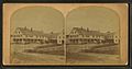
The Souhegan River in the center of Greenville
|
|

Location in Hillsborough County, New Hampshire
|
|
| Country | United States |
| State | New Hampshire |
| County | Hillsborough |
| Incorporated | 1872 |
| Area | |
| • Total | 6.9 sq mi (17.8 km2) |
| • Land | 6.9 sq mi (17.8 km2) |
| • Water | 0 sq mi (0.0 km2) |
| Elevation | 830 ft (250 m) |
| Population
(2020)
|
|
| • Total | 1,974 |
| • Density | 287/sq mi (110.8/km2) |
| Time zone | UTC-5 (Eastern) |
| • Summer (DST) | UTC-4 (Eastern) |
| ZIP code |
03048
|
| Area code(s) | 603 |
| FIPS code | 33-31940 |
| GNIS feature ID | 0873613 |
Greenville is a small town in Hillsborough County, New Hampshire, United States. It's a place where history and nature meet.
In 2020, about 1,974 people lived here. This was a small drop from 2,105 people in 2010. Greenville is easy to find because it's located where three main roads meet: New Hampshire Routes 31, 45, and 123.
Contents
History of Greenville
.jpg)
Greenville was once a part of a nearby town called Mason. It was known as "Mason Village." Greenville is one of the newest and smallest towns in New Hampshire. It officially became its own town in 1872.
The town is built near the "High Falls" on the Souhegan River. The strong water power from these falls helped Greenville become an important center for making things. It was one of the first places in New Hampshire to have factories, especially for making cotton and woolen fabrics.
Because of the waterfalls, Greenville was always a place where goods were made. The Columbian Manufacturing Company started here in 1826. They made textiles (cloth) in Greenville and in nearby New Ipswich. The Columbian company is gone now, but its old brick buildings are still a big part of the town's look. You can also see beautiful Queen Anne style houses on the side streets. Today, the old factory buildings are used for other businesses, storage, and one has even been turned into homes for older people.
Greenville also used to have a Boston & Maine Railroad trestle, which was a type of bridge for trains. It was taken down for safety reasons. Before it was removed, a local inventor named Bronson Potter once flew his private airplane underneath the bridge as part of a dare! The old railroad depot (train station) is still there. It was once a very important building that helped put Greenville "on the map." Now, it's a Chinese restaurant.
-
The Columbian Hotel around 1880.
-
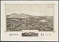
Greenville in 1886.
-
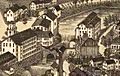
A view of the mills in 1886.
-
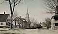
East Main Street in 1919.
-
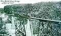
The B. & M. trestle around 1915.


Geography and Nature
Greenville covers about 17.8 square kilometers (about 6.9 square miles) of land. The main town center, called the Greenville CDP, is in the northern part of town. It covers about 3.4 square miles (8.8 square kilometers). The Souhegan River flows right through the middle of town.
The highest point in Greenville is Barrett Hill. It's about 1,270 feet (387 meters) above sea level. The northern part of town gets its water from the Souhegan River. The southern part is drained by smaller streams that flow into the Squannacook River in Massachusetts. All the water in Greenville eventually flows into the Merrimack River. This whole area is part of the Merrimack River watershed, which means all the water flows to the Merrimack River.
Neighboring Towns
Greenville is surrounded by several other towns:
- Wilton (to the north)
- Mason (to the east and south)
- New Ipswich (to the west)
- Temple (to the northwest)
Main Roads in Greenville
Four state highways pass through Greenville:
- NH Route 31: This road runs north and south through the entire town. It connects Greenville to Mason in the south and Wilton in the north.
- NH Route 123: This road meets NH 31 and goes north to Pleasant Street. It then turns left in downtown Greenville and heads south towards New Ipswich.
- NH Route 45: This road starts on Main Street in Greenville. It goes northwest towards Temple.
- NH Route 124: This road crosses the very southwest corner of Greenville. It doesn't connect with any other main roads within the town itself.
Climate
Greenville has a warm-summer humid continental climate. This means it has warm, humid summers and cold, snowy winters. You can see more details about the weather in the chart below.
| Climate data for Greenville, New Hampshire, 1991–2020 normals, extremes 2000–present | |||||||||||||
|---|---|---|---|---|---|---|---|---|---|---|---|---|---|
| Month | Jan | Feb | Mar | Apr | May | Jun | Jul | Aug | Sep | Oct | Nov | Dec | Year |
| Record high °F (°C) | 65 (18) |
70 (21) |
79 (26) |
92 (33) |
92 (33) |
100 (38) |
104 (40) |
104 (40) |
100 (38) |
94 (34) |
80 (27) |
76 (24) |
104 (40) |
| Mean maximum °F (°C) | 54.7 (12.6) |
54.5 (12.5) |
62.7 (17.1) |
76.5 (24.7) |
86.6 (30.3) |
89.5 (31.9) |
91.1 (32.8) |
87.7 (30.9) |
85.7 (29.8) |
74.9 (23.8) |
67.3 (19.6) |
56.1 (13.4) |
92.9 (33.8) |
| Mean daily maximum °F (°C) | 30.2 (−1.0) |
34.2 (1.2) |
41.5 (5.3) |
54.7 (12.6) |
66.3 (19.1) |
74.1 (23.4) |
79.4 (26.3) |
77.8 (25.4) |
70.4 (21.3) |
57.9 (14.4) |
46.3 (7.9) |
35.5 (1.9) |
55.7 (13.2) |
| Daily mean °F (°C) | 22.3 (−5.4) |
24.5 (−4.2) |
31.9 (−0.1) |
43.8 (6.6) |
54.3 (12.4) |
62.9 (17.2) |
68.8 (20.4) |
66.7 (19.3) |
59.7 (15.4) |
47.8 (8.8) |
37.9 (3.3) |
27.5 (−2.5) |
45.7 (7.6) |
| Mean daily minimum °F (°C) | 14.4 (−9.8) |
14.8 (−9.6) |
22.3 (−5.4) |
32.8 (0.4) |
42.4 (5.8) |
51.7 (10.9) |
58.2 (14.6) |
55.7 (13.2) |
48.9 (9.4) |
37.7 (3.2) |
29.5 (−1.4) |
19.6 (−6.9) |
35.7 (2.0) |
| Mean minimum °F (°C) | −4.1 (−20.1) |
−1.1 (−18.4) |
6.3 (−14.3) |
22.1 (−5.5) |
31.0 (−0.6) |
41.1 (5.1) |
48.7 (9.3) |
46.4 (8.0) |
34.9 (1.6) |
25.3 (−3.7) |
14.9 (−9.5) |
3.3 (−15.9) |
−7.0 (−21.7) |
| Record low °F (°C) | −20 (−29) |
−16 (−27) |
−10 (−23) |
10 (−12) |
24 (−4) |
32 (0) |
38 (3) |
38 (3) |
22 (−6) |
10 (−12) |
0 (−18) |
−10 (−23) |
−20 (−29) |
| Average precipitation inches (mm) | 3.42 (87) |
3.28 (83) |
4.25 (108) |
4.35 (110) |
3.73 (95) |
4.26 (108) |
3.64 (92) |
3.84 (98) |
4.25 (108) |
5.42 (138) |
4.11 (104) |
4.96 (126) |
49.51 (1,257) |
| Average snowfall inches (cm) | 19.2 (49) |
19.2 (49) |
15.7 (40) |
2.9 (7.4) |
0.0 (0.0) |
0.0 (0.0) |
0.0 (0.0) |
0.0 (0.0) |
0.0 (0.0) |
0.4 (1.0) |
1.9 (4.8) |
16.1 (41) |
75.4 (192.2) |
| Average precipitation days (≥ 0.01 in) | 9.0 | 7.2 | 8.6 | 9.3 | 10.9 | 10.5 | 9.0 | 8.4 | 7.9 | 9.4 | 8.7 | 9.2 | 108.1 |
| Average snowy days (≥ 0.1 in) | 6.1 | 5.4 | 4.2 | 1.2 | 0.0 | 0.0 | 0.0 | 0.0 | 0.0 | 0.2 | 1.2 | 4.0 | 22.3 |
| Source 1: NOAA | |||||||||||||
| Source 2: National Weather Service (mean maxima and minima 2006–2020) | |||||||||||||
People of Greenville
| Historical population | |||
|---|---|---|---|
| Census | Pop. | %± | |
| 1880 | 1,072 | — | |
| 1890 | 1,255 | 17.1% | |
| 1900 | 1,608 | 28.1% | |
| 1910 | 1,374 | −14.6% | |
| 1920 | 1,346 | −2.0% | |
| 1930 | 1,319 | −2.0% | |
| 1940 | 1,236 | −6.3% | |
| 1950 | 1,280 | 3.6% | |
| 1960 | 1,385 | 8.2% | |
| 1970 | 1,587 | 14.6% | |
| 1980 | 1,988 | 25.3% | |
| 1990 | 2,231 | 12.2% | |
| 2000 | 2,224 | −0.3% | |
| 2010 | 2,105 | −5.4% | |
| 2020 | 1,974 | −6.2% | |
| U.S. Decennial Census | |||
In 2010, there were 2,105 people living in Greenville. These people lived in 861 different homes. About 537 of these were families.
Most people in Greenville are white (97%). A small number of people are from other racial backgrounds. About 2.2% of the people identified as Hispanic or Latino.
About 30% of the homes had children under 18 living there. The average home had about 2.44 people. The average family had about 3.02 people.
The average age of people in Greenville was about 41.6 years old. About 23.2% of the population was under 18. About 12.6% of the population was 65 years or older.
Between 2011 and 2015, the average yearly income for a household was about $52,602. For families, it was about $63,850. The average income per person in the town was $24,457. About 13.8% of the people and 8.6% of families lived below the poverty line.
Notable People
Some interesting people have connections to Greenville:
- Henry Richardson (1917–1981): He was the first African American state legislator in New Hampshire.
- Brian Viglione (born 1979): He is a talented drummer, known for playing in the band The Dresden Dolls.
See also
 In Spanish: Greenville (Nuevo Hampshire) para niños
