
Temple, New Hampshire facts for kids
Quick facts for kids
Temple, New Hampshire
|
|
|---|---|
|
Town
|
|

Town Hall
|
|

Location in Hillsborough County, New Hampshire
|
|
| Country | United States |
| State | New Hampshire |
| County | Hillsborough |
| Incorporated | 1768 |
| Named for | John Temple |
| Area | |
| • Total | 22.5 sq mi (58.2 km2) |
| • Land | 22.2 sq mi (57.6 km2) |
| • Water | 0.2 sq mi (0.6 km2) 0.98% |
| Elevation | 1,024 ft (312 m) |
| Population
(2020)
|
|
| • Total | 1,382 |
| • Density | 62/sq mi (24.0/km2) |
| Time zone | UTC-5 (Eastern) |
| • Summer (DST) | UTC-4 (Eastern) |
| ZIP code |
03084
|
| Area code(s) | 603 |
| FIPS code | 33-76260 |
| GNIS feature ID | 0873737 |
Temple is a small town located in Hillsborough County, New Hampshire, in the United States. In 2020, about 1,382 people lived here. Temple is known for the Temple Mountain State Reservation, which used to be a ski resort.
Contents
History of Temple
The area where Temple is located was first called "Peterborough Slip". This area also included what is now the town of Sharon.
Early Settlers and Founding
In 1758, some of the first settlers arrived. These included Major Ephraim Heald and his wife Sarah. His brother, Peter Heald, and their cousin, Oliver Heald, also came. Peter Heald is often seen as the founder of Temple. His son, also named Peter, was the first boy born in the town.
In 1768, Temple officially became a town. This was done by the colonial Governor John Wentworth. He named the town after his lieutenant governor, John Temple. Another early settler, Peter Felt, arrived in 1769 with his wife Lucy Andrews.
Industries and Growth
In 1780, a company called Temple Glassworks was started by Robert Hewes from Boston. This company made glass. Even though the company is no longer around, any glass items from Temple Glassworks are very rare and valuable today.
By 1859, Temple had a population of 579 people. The town had two sawmills, which cut wood. It also had one gristmill, which ground grain, and a tannery, which processed animal hides. The town of Temple, Maine was later named after Temple, New Hampshire.
Views and Landscape
The land in Temple is generally hilly and rocky. It is also high up, offering great views to the east and south. In 1823, two writers, John Farmer and Jacob Bailey Moore, noted something special. They wrote that from the highest point in Temple, you could see twenty meetinghouses on a clear day.
-
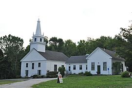
Congregational Church
-
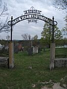
Cemetery gate
-
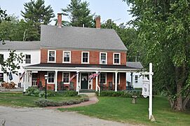
Birchwood Inn
-
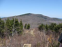
View from Temple Mountain


Geography of Temple
Temple covers a total area of about 58.2 square kilometers (22.5 square miles). A small part of this area, about 0.6 square kilometers (0.2 square miles), is covered by water. This means water makes up about 0.98% of the town's total area.
Waterways and Mountains
Water flows east from Temple into Blood Brook and its smaller stream, Temple Brook. These brooks are part of the Souhegan River system. The highest point in Temple is 2,190 feet (668 meters) above sea level. This spot is on an eastern part of South Pack Monadnock Mountain.
South of Route 101, a mountain called Temple Mountain forms the western edge of the town for several miles. This mountain is 2,045 feet (623 meters) high.
Neighboring Towns
Temple shares its borders with several other towns:
- Greenfield (to the north)
- Lyndeborough (to the northeast)
- Wilton (to the east)
- Greenville (to the southeast)
- New Ipswich (to the south)
- Sharon (to the west)
- Peterborough (to the northwest)
Population Changes
| Historical population | |||
|---|---|---|---|
| Census | Pop. | %± | |
| 1790 | 747 | — | |
| 1800 | 867 | 16.1% | |
| 1810 | 941 | 8.5% | |
| 1820 | 752 | −20.1% | |
| 1830 | 647 | −14.0% | |
| 1840 | 576 | −11.0% | |
| 1850 | 579 | 0.5% | |
| 1860 | 501 | −13.5% | |
| 1870 | 421 | −16.0% | |
| 1880 | 492 | 16.9% | |
| 1890 | 342 | −30.5% | |
| 1900 | 313 | −8.5% | |
| 1910 | 284 | −9.3% | |
| 1920 | 263 | −7.4% | |
| 1930 | 239 | −9.1% | |
| 1940 | 258 | 7.9% | |
| 1950 | 330 | 27.9% | |
| 1960 | 361 | 9.4% | |
| 1970 | 441 | 22.2% | |
| 1980 | 692 | 56.9% | |
| 1990 | 1,194 | 72.5% | |
| 2000 | 1,297 | 8.6% | |
| 2010 | 1,366 | 5.3% | |
| 2020 | 1,382 | 1.2% | |
| U.S. Decennial Census | |||
The population of Temple has changed over many years. In 1790, there were 747 people living in the town. The population grew to 941 by 1810. After that, it slowly decreased for many years. By 1930, only 239 people lived in Temple.
However, the population started to grow again after 1940. It has been increasing steadily since then. In 2000, there were 1,297 people. By 2020, the population reached 1,382 people.
Community Life
In 2000, there were 440 households in Temple. Many of these households, about 67.5%, were married couples living together. About 42.3% of households had children under 18 years old. The average household had about 2.91 people.
The median age in Temple was 37 years old. This means half the people were younger than 37 and half were older. About 29.8% of the population was under 18. About 8.4% of the population was 65 or older.
The median income for a household in Temple was $56,500. For families, the median income was $64,297. A small number of families, about 2.8%, lived below the poverty line.
See also
 In Spanish: Temple (Nuevo Hampshire) para niños
