
Stony Brook (Souhegan River tributary) facts for kids
Quick facts for kids Stony Brook |
|
|---|---|

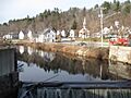
Stony Brook near its mouth in Wilton, NH
|
|


|
|
| Country | United States |
| State | New Hampshire |
| County | Hillsborough |
| Towns | Greenfield, Lyndeborough, Wilton |
| Physical characteristics | |
| Main source | Lyndeborough Mountain Lyndeborough 1,270 ft (390 m) 42°55′14″N 71°48′19″W / 42.92056°N 71.80528°W |
| River mouth | Souhegan River Wilton 338 ft (103 m) 42°50′39″N 71°44′20″W / 42.84417°N 71.73889°W |
| Length | 10.6 mi (17.1 km) |
Stony Brook is a river about 10.6 miles (17.1 kilometers) long. It is located in southern New Hampshire in the United States. This river is a tributary of the Souhegan River. A tributary is a smaller stream or river that flows into a larger one. The Souhegan River then flows into the Merrimack River, and finally, the water reaches the Gulf of Maine.
Contents
Where Stony Brook Starts and Flows
Stony Brook begins in the town of Lyndeborough, New Hampshire. It starts in a valley found between two mountains: Lyndeborough Mountain to the north and Winn Mountain to the south.
Stony Brook's Journey
From its start, Stony Brook flows west into the town of Greenfield. After that, it turns to the southeast. It then flows back into Lyndeborough. The river continues its journey until it reaches the Souhegan River in the town of Wilton. Wilton is known as a mill town, which means it historically had many factories that used water power from rivers.
Roads and Railways Along the Brook
A road called New Hampshire Route 31 runs next to Stony Brook. This road follows the river from Greenfield all the way to Wilton. An old railway line, once part of the Hillsboro Branch of the Boston and Maine Railroad, also runs alongside the brook.
Images for kids
-
Stony Brook near its mouth in Wilton, NH
