
Royalston, Massachusetts facts for kids
Quick facts for kids
Royalston, Massachusetts
|
||
|---|---|---|

Town Hall and First Congregational Church
|
||
|
||
| Nickname(s):
"Where Many Waters Fall"
|
||

Location in Worcester County and the state of Massachusetts.
|
||
| Country | United States | |
| State | Massachusetts | |
| County | Worcester | |
| Settled | 1762 | |
| Incorporated | 1765 | |
| Government | ||
| • Type | Open town meeting | |
| Area | ||
| • Total | 42.5 sq mi (110.0 km2) | |
| • Land | 41.9 sq mi (108.5 km2) | |
| • Water | 0.6 sq mi (1.5 km2) | |
| Elevation | 1,015 ft (309 m) | |
| Population
(2020)
|
||
| • Total | 1,250 | |
| • Density | 29.41/sq mi (11.36/km2) | |
| Time zone | UTC-5 (Eastern) | |
| • Summer (DST) | UTC-4 (Eastern) | |
| ZIP code |
01368
|
|
| Area code(s) | 351 / 978 | |
| FIPS code | 25-58580 | |
| GNIS feature ID | 0619488 | |
| Website | http://www.royalston-ma.gov/ | |

Royalston is a small town located in Worcester County, Massachusetts, United States. In 2020, about 1,250 people lived here. It is known for its beautiful natural areas and historic village center.
Contents
History of Royalston

Royalston is a small town in the North Quabbin area of Massachusetts. It was named after Isaac Royall, a businessperson from Medford, Massachusetts. He helped found the town in a land deal back in 1765.
Most of Royalston's land is covered by forests and wetlands. You can find several nature reservations and wildlife management areas here. Two important ones are the Tully Lake flood protection area and the Royalston Falls reservation.
The largest community in town is the village of South Royalston. It is located in the southeastern part of Royalston. The historic center of Royalston has a well-preserved colonial New England town center. This area includes the town hall, post office, church, and the town's library.
Geography and Transportation in Royalston

Royalston covers about 42.5 square miles (110 square kilometers). Most of this area is land, with a small part being water. The town is located in a hilly part of central Massachusetts.
The town center is near Frye Hill. This hill slopes down into the Tully River valley. The Tully River flows through Long Pond and Tully Lake. It then joins the Millers River in nearby Athol. Several other small streams also flow through Royalston. Some areas along these streams are marshlands.
To the northwest, White Hill is the highest point in town. It rises to 1,361 feet (415 meters). A famous natural spot is Royalston Falls, located near the New Hampshire border.
Wildlife and Natural Areas
Royalston is home to several wildlife management areas. These include Birch Hill, Millers River, Lawrence Brook, and Fish Brook. The first two cover large parts of the eastern half of town. There are also two state forests near West Royalston.
Neighboring Towns and Cities
Royalston is in the northwestern corner of Worcester County. It shares borders with Franklin County to the west. To the north, it borders Cheshire County, New Hampshire.
Nearby towns include Athol to the south and Winchendon to the east. The town center is about 24 miles (39 km) west-northwest of Fitchburg. It is also about 68 miles (109 km) northwest of Boston.
Roads and Public Transport
Royalston does not have any major highways. The closest main road is Route 2 to the south. You can reach it through Phillipston and Templeton.
Route 32 goes through the western part of town. Route 68 also passes through Royalston. It connects South Royalston with the central village and West Royalston. There is a rail line in South Royalston, but no public train service. The nearest small airport is in Orange.
Royalston Population and People
| Historical population | ||
|---|---|---|
| Year | Pop. | ±% |
| 1850 | 1,546 | — |
| 1860 | 1,486 | −3.9% |
| 1870 | 1,354 | −8.9% |
| 1880 | 1,192 | −12.0% |
| 1890 | 1,030 | −13.6% |
| 1900 | 958 | −7.0% |
| 1910 | 792 | −17.3% |
| 1920 | 819 | +3.4% |
| 1930 | 744 | −9.2% |
| 1940 | 795 | +6.9% |
| 1950 | 838 | +5.4% |
| 1960 | 800 | −4.5% |
| 1970 | 809 | +1.1% |
| 1980 | 955 | +18.0% |
| 1990 | 1,147 | +20.1% |
| 2000 | 1,254 | +9.3% |
| 2010 | 1,258 | +0.3% |
| 2020 | 1,250 | −0.6% |
| 2023* | 1,276 | +2.1% |
| * = population estimate. Source: United States Census records and Population Estimates Program data. |
||
In 2000, Royalston had 1,254 people living in 449 households. About 36% of households had children under 18. The average household had almost 3 people.
The population was spread out by age. About 29% were under 18 years old. Around 30% were between 25 and 44 years old. The median age was 38 years.
Education in Royalston
Royalston has one public elementary school. It is called the Royalston Community School. This school teaches students up to Grade 6.
For middle and high school, students attend schools in the Athol-Royalston Regional School District. There is also an independent school called The Village School. It serves students from preschool to Grade 6. The new school building opened in 2018.
Natural Attractions in Royalston
Royalston is famous for its beautiful natural areas. It has three waterfalls: Royalston Falls, Doane's Falls, and Spirit Falls.
You can enjoy many outdoor activities at Tully Lake. The Army Corps of Engineers manages this area. You can go kayaking, hiking, or mountain biking. There is even a disc golf course. The Trustees of Reservations also manages the Tully Lake Campground.
Notable People from Royalston
Many interesting people have come from Royalston, including:
- Alexander Bullock, a politician
- Mary Floyd Cushman, a doctor
- Lysander Cutler, a politician
- Elmer H. Fisher, an architect
- Joseph Lee Heywood, a cashier
- Horace Jacobs, a physician
- Whitman Jacobs, a clergyman
- Abner Jones, a minister
- Asahel Peck, a politician
- Hamilton S. Peck, a politician
- George C. Richardson, a politician
- Malcolm Rogers, a museum curator
- Nancy Amelia Woodbury Priest Wakefield, a poet
Images for kids
-
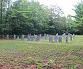
Newton Cemetery, one of several Royalston cemeteries – this one is located near the trailhead to Royalston Falls.
-
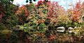
Millers River from Main Street – South Royalston Thatcher


See also
 In Spanish: Royalston (Massachusetts) para niños
