Millers River (Middlesex) facts for kids
Quick facts for kids Millers River |
|
|---|---|

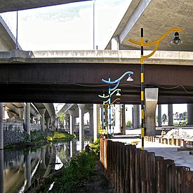
Millers River under I-93 highway
|
|
| Location | Cambridge, Massachusetts Boston, Massachusetts |
| Status | public walkway |
| Public transit access | Community College (MBTA station) |
The Millers River was once a river in Middlesex County, Massachusetts. It was also often called Miller's River. Today, most of it is gone, covered up by landfill (trash and dirt used to fill in land) and "made land" (new land created by filling waterways). What's left is a small part of the river, like a leftover piece of the wet areas and open water that used to separate Cambridge from Charlestown, Massachusetts. It's a bit tricky to know exactly where the river flowed in the past. Because of this, the borders between Charlestown, Cambridge, and Somerville might have changed over time.
Contents
How the River Changed
The Millers River used to flow into the Charles River. This was important for boats carrying goods to businesses and factories along its banks, even in the early days of the colonies. Long ago, it was known as Willis Creek. You can see this name on old maps, like the 1777 Pelham Map.
In the late 1800s, people started using the Millers River as a dumping ground. Waste from meat factories and slaughterhouses was thrown into it. This caused a terrible smell and led to serious health problems for people living nearby.
These issues helped create some of the first laws in Massachusetts to stop pollution and protect public health. These laws also set an example for early environmental protection rules across the United States. Because of these problems, a law called Chapter 91 was made in 1866. This law helps control how people use tidal waterways and protects public well-being even today. The industrial area around Millers River and the lower Charles River basin became known as "the Lost Half-Mile" because it was hard to reach and very polluted.
Protecting the River During Construction
A small part of the Millers River still exists today. It runs along and under the northern section of the I-93 Highway. This part of the river became a big topic of debate during the planning for the Big Dig highway project. Many groups, like the Charles River Watershed Association and The Conservation Law Foundation, worked hard to protect the Millers River. They also wanted to make sure people could visit and enjoy it.
Rules for the project stopped the remaining part of the river from being filled in. Also, special permits from Chapter 91 made sure that people could walk along the northern bank of the Charles River, which was previously closed off.
Walking Paths and Art
Today, there's a walking path along the remaining part of Millers River. It connects the Charles River to Rutherford Avenue in Charlestown, Massachusetts. This path has fun light poles, signs that tell the river's history, and native wetland plants.
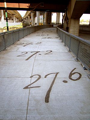
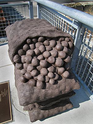
A public art project called Millers River Littoral Way is also along the path. It includes artworks, pictures, special lighting, and stainless steel benches. You can even see numbers etched into the ground that show how deep the harbor was before the land was filled in. There's also the Potato Shed Memorial, which marks where large potato storage buildings once stood. These artworks help people find their way and learn about the area's past as they walk under the huge Interstate Highway 93. An artist named Ross Miller created the idea and the artworks for this path.
The mouth of Millers River, where it meets the Charles River, was closed off by train tracks and docks since the 1830s. But it was opened up again as part of the Central Artery construction. Where Millers River meets the north bank of the Charles River, a new park was finished in 2012. This park lets people walk and bike into a part of industrial Boston that was once impossible to reach.
If you're coming from the west, from North Point Park in Cambridge, you can cross over Millers River on the North Bank Pedestrian Bridge. This bridge was paid for by a government program. It's made for both bikes and walkers. The bridge curves over MBTA train tracks and goes between a train control tower and a highway ramp. It ends on the east side of Millers River, under the Zakim Bridge. This area has a rugged look, built with old granite blocks from a seawall. A light art project called 5 Beacons for the Lost Half Mile helps guide people from under the highway into Paul Revere Park in Charlestown.
What's Next for Millers River
Experts from the Charles River Watershed Association and other groups have found parts of the Millers River that are now buried. They believe these areas could be developed to make local water cleaner and store more rainwater naturally. Ways to do this include opening up buried drains and creating areas where rainwater can soak into the ground. They are also looking into "daylighting" parts of the river that are currently filled in, meaning bringing them back to the surface.
The Massachusetts Department of Conservation and Recreation is making plans to improve and protect the natural environment of Millers River and the lower Charles River Basin. They also want to encourage people to use these areas for fun activities like walking and relaxing.
 | Stephanie Wilson |
 | Charles Bolden |
 | Ronald McNair |
 | Frederick D. Gregory |


