Ware River facts for kids
Quick facts for kids Ware River |
|
|---|---|

|
|
| Physical characteristics | |
| Main source | Hubbardston 830 feet (250 m) 42°28′19″N 71°59′56″W / 42.472°N 71.999°W |
| River mouth | Three Rivers 290 feet (88 m) 42°10′51″N 72°21′55″W / 42.1807°N 72.3654°W |
| Length | 35.4 miles (57.0 km) |
| Basin features | |
| Basin size | 96 square miles (250 km2) |
The Ware River is a 35.4-mile-long (57.0 km) river in central Massachusetts. It has two main parts, called forks. Both the west and east forks start in Hubbardston, Massachusetts. The Ware River flows southwest through the middle of the state. It then joins the Quaboag River at Three Rivers, Massachusetts. Together, they form the Chicopee River, which eventually flows into the Connecticut River.
The West Branch of the Ware River first flows into Brigham Pond. This pond is created by the Brigham Pond Dam in Hubbardston. The East Branch of the river starts north of Bickford Pond, near the town of Princeton. A large part of Hubbardston is within the Ware River's watershed. This means that water from this area flows into the Ware River. The Ware River is also an important part of the drinking water system for the greater Boston area. This system is managed by the Massachusetts Water Resources Authority. There is also a special dam on the Ware River in Hubbardston and Barre. This dam helps control floods and was built by the U.S. Army Corps of Engineers.
Contents
Discovering the Ware River's Past
The Ware River got its name from early "fish weirs." These were structures, like fences, built in the river to catch fish. Imagine a big project that started in 1928! This project involved building a 12.5-mile-long (20.1 km) tunnel to connect the Ware River to the Wachusett Reservoir. This huge tunnel, called the Wachusett-Coldbrook Tunnel, was 12-foot-wide (3.7 m). Workers had to blast through solid rock 200 feet (60 m) deep to create it.
In 1931, the first water from the Ware River flowed through this tunnel. This was a big deal because a long period of dry weather had made the Wachusett Reservoir very low. The new water from the Ware River helped save the reservoir from drying up completely. In 1933, another important tunnel, the Quabbin Aqueduct, was finished. This tunnel was ready to carry water from the Quabbin Reservoir, which was still being built. Today, the Swift River Diversion tunnel is used to move water around the dam area.
Exploring the Ware River's Landscape
The Ware River begins high up, about 830 feet (250 m) above sea level. It gets its water from many small streams in its watershed. The river then flows downhill, ending at the village of Three Rivers at about 290 feet (88 m) above sea level. As the river flows, it passes through many old mill towns. The river's drop in elevation provided power for these mills long ago. One of the biggest towns along the river is Ware, Massachusetts, which shares the river's name. The Ware River is also part of the larger Connecticut River Watershed.
Towns Along the Ware River
- Barre (South Barre, Barre Plains)
- Hardwick (Gilbertville, Old Furnace, Wheelwright)
- Hubbardston
- Princeton
- Ware
- Westminster
- Warren
- Palmer (Three Rivers, Thorndike)
Important Structures on the Ware River
The Barre Falls Dam: Controlling Floods
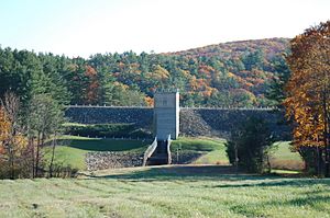
The Barre Falls Dam is located on the Ware River in Hubbardston, Massachusetts. It's about 0.3 miles (0.5 km) below where the river's east and west branches meet. This dam was built by the United States Army Corps of Engineers. Its main job is to greatly reduce flooding along the Ware, Chicopee, and Connecticut rivers. Building the dam started in May 1956 and finished in July 1958. It cost about $2 million to build.
The dam itself is made of earth and has stone on its slopes. It is 885 feet (270 m) long and 69 feet (21 m) high. There are also three smaller walls, called dikes, that are 3,215 feet (980 m) long in total. The dam has a special concrete overflow area, called a spillway, that is 60 feet (18 m) long. This spillway is 23 feet (7.0 m) lower than the top of the dam.
There isn't a permanent lake at the Barre Falls Dam. Instead, there's a large area that is usually empty. This area can store floodwaters and covers about 1,500 acres (6.1 km2) in the towns of Barre, Hubbardston, Rutland, and Oakham. The entire project, including all its land, covers 2,407 acres (9.74 km2). The Barre Falls Dam can hold a huge amount of water for flood control. It can store up to 7.82 billion US gallons (29,600,000 m3) of water! This is like having 8.2 inches (21 cm) of water covering its drainage area of 55 square miles (140 km2).
The Barre Falls reservoir area is part of the Upper Ware River Watershed. The Massachusetts Department of Conservation and Recreation (MDCR) takes care of this land. They make sure the water quality is protected. The Massachusetts Water Resources Authority (MWRA) manages these water resources. They are an important part of the public water supply for the Boston area.
The Ware River Diversion: Moving Water Around
The Ware River Diversion facility is a special place that helps move water from the Ware River into the Quabbin Aqueduct. This facility is used to start a natural siphon. A siphon is like a giant straw that helps water flow from one place to another without needing pumps. This allows water to flow from the Quabbin Reservoir to the Wachusett Reservoir, or even from Wachusett Reservoir back to the Quabbin Reservoir if needed.
 | Aaron Henry |
 | T. R. M. Howard |
 | Jesse Jackson |


