
Quaboag River facts for kids
Quick facts for kids Quaboag River |
|
|---|---|

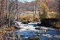
The Quaboag River near Warren
|
|
| Physical characteristics | |
| Main source | Quaboag Pond 594 feet (181 m) 42°11′45″N 72°04′13″W / 42.19583°N 72.07028°W |
| River mouth | Three Rivers, Massachusetts 290 feet (88 m) 42°10′50″N 72°21′54″W / 42.18056°N 72.36500°W |
| Length | 25.7 miles (41.4 km) |
| Basin features | |
| Basin size | 150 sq mi (390 km2) |
The Quaboag River is a river in Massachusetts that is about 25.7-mile-long (41.4 km). It starts at Quaboag Pond in Brookfield. The river begins at an elevation of 594 feet (181 m) above sea level. It then flows west until it reaches the village of Three Rivers, Massachusetts, where its elevation is 290 feet (88 m).
Contents
River History: How the Quaboag Got Its Name
The Quaboag River gets its name from Quaboag Pond. The name "Quaboag" comes from an old Native American word. It means "red-water place" or "red-water pond." Long ago, this pond was sometimes called Podunk Pond.
Industry Along the Quaboag River
Early industries began to grow along the Quaboag River. This happened downstream from West Brookfield. The river here drops about 300-foot (91 m) in elevation. This big drop created strong waterpower. This power was very useful for factories.
Major factories and heavy industries were built in Warren, Massachusetts. They used the river's waterpower to run their machines. Many dams were built on the river to help create this waterpower. However, some of these dams were destroyed by floods. They were never fixed or rebuilt. You can still see parts of them today. These old pieces show us the river's important past in industry.
River Journey: Where the Quaboag River Flows
The Quaboag River starts at Quaboag Pond. From there, it flows through several towns. These towns include Brookfield, West Brookfield, and Warren. As it flows through West Brookfield, water from Lake Wickaboag also joins the river.
After passing through Warren, the Quaboag River meets two other rivers. These are the Ware River and the Swift River. They all come together in Three Rivers. When they join, they form a new, larger river called the Chicopee River. This means the Quaboag River is an important part of the larger Chicopee River Watershed.
River Basin: Water Sources for the Quaboag
Many small streams and brooks feed into the Quaboag River. These come from the towns of East Brookfield, Brookfield, West Brookfield, and Warren. They all help drain water into the Quaboag River.
Lake Lashaway in East Brookfield is one important water source. It drains directly into Quaboag Pond, which is where the Quaboag River begins. Several other large water sources also flow into the pond. The river basin also includes important wetland areas. The two largest wetlands are the Great Swamp, south of Brookfield, and the Allen Swamp, south of East Brookfield.
Fun on the River: Kayaking and Canoeing
The Quaboag River is a popular spot for whitewater kayakers and canoeists. They often start their trip at Lucy Stone Park in Warren. They then paddle downstream to a spot along Route 67.
The river is considered a Class III river. This means it has some exciting rapids. Some of the rapids have names, like Mousehole and Trestle Rapid. These are found above an old dam. Downstream, you'll find Angel's Field and Devil's Gorge. Devil's Gorge has a sudden four-foot waterfall called Quaboag Drop.
The Quaboag River usually has enough water for paddling. This is because it has a large river basin that collects a lot of water. You can check the water level using the Brimfield USGS gauge online. The river is usually good for paddling when the gauge shows levels above four feet. There is one part of the river where you must carry your boat around a dam. This dam is next to a factory and cannot be paddled over.
Images for kids
-
A broken dam on the Quaboag River, showing its industrial past.

