West Brookfield, Massachusetts facts for kids
Quick facts for kids
West Brookfield, Massachusetts
|
||
|---|---|---|

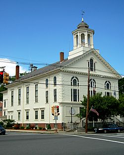
Town Hall
|
||
|
||

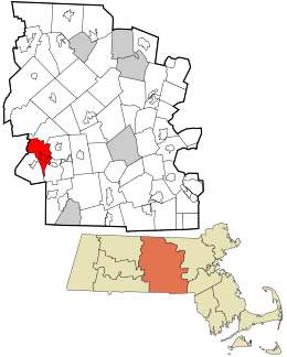
Location in Worcester County and the state of Massachusetts.
|
||
| Country | United States | |
| State | Massachusetts | |
| County | Worcester | |
| Settled | 1664 | |
| Incorporated | 1848 | |
| Government | ||
| • Type | Open town meeting | |
| Area | ||
| • Total | 21.1 sq mi (54.7 km2) | |
| • Land | 20.5 sq mi (53.0 km2) | |
| • Water | 0.6 sq mi (1.7 km2) | |
| Elevation | 633 ft (193 m) | |
| Population
(2020)
|
||
| • Total | 3,833 | |
| • Density | 181.7/sq mi (70.07/km2) | |
| Time zone | UTC-5 (Eastern) | |
| • Summer (DST) | UTC-4 (Eastern) | |
| ZIP code |
01585
|
|
| Area code(s) | 508 / 774 | |
| FIPS code | 25-75400 | |
| GNIS feature ID | 0618392 | |
| Website | http://www.wbrookfield.com/ | |
West Brookfield is a town located in Worcester County, Massachusetts, in the United States. In 2020, about 3,833 people lived there.
West Brookfield is known as the birthplace of Lucy Stone, a famous American leader who fought for women's rights. Also, George and Charles Merriam, who published the well-known Webster's Dictionary, grew up in this town.
If you want to learn more about the specific area called West Brookfield (CDP), you can check out the article West Brookfield (CDP), Massachusetts.
Contents
History of West Brookfield
West Brookfield was first settled by European people in 1665. It officially became its own town in 1848. Before that, it was part of Brookfield, which was originally called the Quaboag Plantation.
Asparagus in West Brookfield
Many people believe that West Brookfield is where asparagus was first grown in the New World. A man named Diederik Leertouwer came to the United States in 1784. He wanted to help with trade between the Netherlands and New England.
Later, he lived in West Brookfield from 1794 to 1798. At that time, West Brookfield was even bigger than Worcester. It was even considered to be the county seat. Local stories say that Diederik Leertouwer brought asparagus plants from his home country. He was the first to plant them in this area. This fact was found in an old cookbook. Even today, you can find wild asparagus growing here. Leertouwer passed away in West Brookfield and is buried in the Old Indian Cemetery.
The Rock House Reservation
The town is also home to the Rock House Reservation. This is a huge, cave-like rock shelter. It was formed about 10,000 years ago after glaciers melted away. Native Americans used this shelter as a winter camp.
In the mid-1800s, the Rock House was part of a farm owned by William Adams. Later, his descendant, F. A. Carter, built a dam on a small stream. This created Carter Pond. Carter also built a small house that is now a museum and nature center. The reservation is open every day from sunrise to sunset, and it's free to visit.
Geography of West Brookfield
West Brookfield covers a total area of about 21.1 square miles (54.7 square kilometers). Most of this area, about 20.5 square miles (53.0 square kilometers), is land. The rest, about 0.6 square miles (1.7 square kilometers), is water.
Town Borders and Roads
West Brookfield shares its borders with several other towns. To the southeast, it borders Brookfield. To the north, it borders North Brookfield and New Braintree. To the west, it borders Ware, and to the southwest, it borders Warren.
The main road that goes through West Brookfield is Route 9. Other important roads include Route 67, Route 19 (which starts in West Brookfield), and Route 32.
Population of West Brookfield
| Historical population | ||
|---|---|---|
| Year | Pop. | ±% |
| 1850 | 1,344 | — |
| 1860 | 1,548 | +15.2% |
| 1870 | 1,842 | +19.0% |
| 1880 | 1,917 | +4.1% |
| 1890 | 1,592 | −17.0% |
| 1900 | 1,448 | −9.0% |
| 1910 | 1,327 | −8.4% |
| 1920 | 1,281 | −3.5% |
| 1930 | 1,255 | −2.0% |
| 1940 | 1,387 | +10.5% |
| 1950 | 1,674 | +20.7% |
| 1960 | 2,053 | +22.6% |
| 1970 | 2,653 | +29.2% |
| 1980 | 3,026 | +14.1% |
| 1990 | 3,532 | +16.7% |
| 2000 | 3,804 | +7.7% |
| 2010 | 3,701 | −2.7% |
| 2020 | 3,833 | +3.6% |
| 2022* | 3,817 | −0.4% |
| * = population estimate. Source: United States Census records and Population Estimates Program data. |
||
In 2000, there were 3,804 people living in West Brookfield. These people lived in 1,362 households, and 965 of those were families. The population density was about 185.8 people per square mile.
About 33.6% of households had children under 18 living with them. Most households, 59.4%, were married couples. About 23.6% of all households were made up of people living alone.
The average age of people in the town was 43 years old. About 22.9% of the population was under 18. About 20.9% of the population was 65 years old or older.
Merriam-Gilbert Public Library
The Merriam-Gilbert Public Library was built in 1880. Charles Merriam, who was born in West Brookfield in 1806, paid for its construction. He was famous for publishing the very first Webster's Dictionary.
The building was first called the Merriam Public Library and Reading Room. In 1960, it was renamed the Merriam-Gilbert Public Library. This happened after Helen E. Gilbert, who also grew up in West Brookfield, left a generous gift to the library.
Library Building Changes
The outside of the library building looks mostly the same as it did when it was built. However, a small tower on the roof, called a cupola, was destroyed in a big storm in 1938.
In 1997, the building was renovated. An elevator tower was added to make the building easier for everyone to use. This project also updated the library inside.
Education in West Brookfield
West Brookfield has one public school called West Brookfield Elementary School. This school teaches students from kindergarten through sixth grade.
For older students, West Brookfield works with the town of Warren. Students in grades 7 through 12 from both towns go to Quaboag Regional Middle/High School. This school is located in Warren.
Notable People from West Brookfield
West Brookfield has been home to several important people:
- Lucy Stone: A very important American leader who fought for women's right to vote.
- George Merrick Rice: A businessman who also served as a state senator in Massachusetts.
- Daniel Henry Chamberlain: He was the 76th Governor of South Carolina.
- Doug McMurdy: A hockey player for the Springfield Indians. He also won the Red Tilson Trophy.
See also
 In Spanish: West Brookfield (Massachusetts) para niños
 | Precious Adams |
 | Lauren Anderson |
 | Janet Collins |


