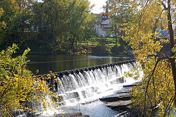
Chicopee River facts for kids
Quick facts for kids Chicopee River |
|
|---|---|

Chicopee Falls
|
|
| Etymology | "violent/raging/turbulent waters" in an Algonquin language |
| Country | US |
| Physical characteristics | |
| Main source | Palmer, Massachusetts 42°10′51″N 72°21′55″W / 42.1807°N 72.3654°W |
| River mouth | Connecticut River 42°08′54″N 72°37′18″W / 42.1482°N 72.6217°W |
| Length | 18.0 mi (29.0 km) |
| Basin features | |
| Basin size | 721 square miles (1,870 km2) |
The Chicopee River is a river in Massachusetts, USA. It flows for about 18.0-mile-long (29.0 km) before joining the Connecticut River. This river is known for its fast-moving water. It also has the largest "drainage basin" of all the rivers that flow into the Connecticut River.
The Chicopee River starts in a village called Three Rivers in Palmer, Massachusetts. It then flows through towns like Ludlow and parts of Springfield. Finally, it meets the Connecticut River in downtown Chicopee, Massachusetts.
Contents
Why is the Chicopee River Important?
The River's Huge Water Collection Area
Even though the Chicopee River is only 18 miles (29 km) long, its basin, or "drainage area," is huge. This area covers 721 square miles (1,870 km2). This makes it the largest river basin in all of Massachusetts. It is also the biggest area that sends water to the Connecticut River.
A river basin is like a giant funnel. It's a geographic area where all the rain and water from streams and smaller rivers flow into one main river. The Chicopee River's basin is so big that it includes parts of 32 different cities and towns! All this water eventually makes its way to the Connecticut River.
A Big Drop for Power
During the time of the Industrial Revolution, the Chicopee River was very important. Many factories and mills wanted to use its power. This is because the river drops a lot in a short distance.
The Chicopee River drops 260 feet (79 m) over its 18-mile (29 km) journey to the Connecticut River. To compare, the much longer Connecticut River only drops 50 feet (15 m) from Chicopee to Old Saybrook, Connecticut. This big drop made the Chicopee River perfect for creating "hydropower." Hydropower uses the force of moving water to create energy.
Because of this, many mills were built along the Chicopee River. Today, some of these old mills are being used for new purposes. For example, a famous mill in Springfield's Indian Orchard area is now a space for artists.
As of 2011, there are six hydropower dams on the Chicopee River. These dams help to use the river's strong flow. On average, the Chicopee River flows at 900 cubic feet per second. That's about 581,644,800 gallons of water every single day!
How Chicopee Became a City
Historical records often say that the Chicopee River flows into the Connecticut River in Springfield, Massachusetts. However, this changed in 1848. That year, the City of Chicopee was created. It was formed from the northern parts of Springfield.
Some people in Springfield did not want it to become a larger, "chartered" city with a mayor. So, they came up with a plan. They decided to create Chicopee by taking away a large part of Springfield's population. Their idea was that Springfield would then be too small to become a chartered city.
Their plan worked, and Chicopee became its own city. However, Springfield still became a city just four years later. Chicopee also became a city not long after that. Today, the Chicopee River meets the Connecticut River about 0.5 miles (0.8 km) north of Springfield's border. This means the river's meeting point is now in Chicopee, not Springfield.
 | Delilah Pierce |
 | Gordon Parks |
 | Augusta Savage |
 | Charles Ethan Porter |

