Barre, Massachusetts facts for kids
Quick facts for kids
Barre, Massachusetts
|
|||
|---|---|---|---|

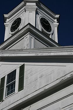
Barre Town Hall
|
|||
|
|||
| Motto(s):
"Tranquil and Alert"
|
|||

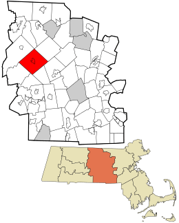
Location in Worcester County and the state of Massachusetts.
|
|||
| Country | United States | ||
| State | Massachusetts | ||
| County | Worcester | ||
| Settled | 1720 | ||
| Incorporated | 1774 | ||
| Government | |||
| • Type | Open town meeting | ||
| Area | |||
| • Total | 44.6 sq mi (115.5 km2) | ||
| • Land | 44.3 sq mi (114.8 km2) | ||
| • Water | 0.3 sq mi (0.7 km2) | ||
| Elevation | 886 ft (270 m) | ||
| Population
(2020)
|
|||
| • Total | 5,530 | ||
| • Density | 123.99/sq mi (47.88/km2) | ||
| Time zone | UTC−5 (Eastern) | ||
| • Summer (DST) | UTC−4 (Eastern) | ||
| ZIP Code |
01005
|
||
| Area codes | 351/978 | ||
| FIPS code | 25-03740 | ||
| GNIS feature ID | 0619475 | ||
| Website | www.townofbarre.com | ||
Barre (pronounced BARR-ee) is a town in Worcester County, Massachusetts, in the United States. In 2020, about 5,530 people lived there.
Contents
History of Barre
The land where Barre is located was originally the home of the Nipmuc people. European settlers first arrived in 1720. At that time, it was known as the Northwest District of Rutland.
The town was officially formed on June 17, 1774. It was first named Hutchinson, after Thomas Hutchinson, who was the governor of the Massachusetts colony.
However, Governor Hutchinson supported the British king, which made many local people unhappy. So, on November 7, 1776, the town's name was changed to Barre. This new name honored Colonel Isaac Barré, an Irish-born member of the British Parliament. He was a strong supporter of American independence.
Railroad and Transportation
In 1849, a plan was made to build a railroad from Worcester to Barre. This company was called the Boston, Barre and Gardner Railroad. However, they couldn't get enough money to start building.
The project was restarted in 1869, but the route was changed. The new railroad went between Worcester and Gardner, completely missing Barre. Even though it didn't reach Barre, it kept the name Boston, Barre and Gardner RR. The closest train station to Barre was in Hubbardston, about 7 miles away.
A Local Hero: Basil Izzi
On April 11, 1943, Barre held a big celebration for Basil Izzi. He was a local man who served in the United States Navy Armed Guard. His ship was attacked and sunk during World War II.
Basil Izzi survived for 83 days on a life raft in the Atlantic Ocean. When he returned home, the town gave him a huge welcome parade. People in Barre still say it was the longest parade ever held in Massachusetts!
In 2015, a road bridge near South Barre was named the "Seaman 2nd Class Basil D. Izzi Memorial Bridge" to honor him. This bridge carries Massachusetts Route 32 over the Ware River.
Geography of Barre
Barre covers an area of about 44.6 square miles. Most of this area, about 44.3 square miles, is land. The rest, about 0.3 square miles, is water. The Ware River flows through Barre.
Barre shares its borders with several other towns:
- To the northeast: Hubbardston
- To the southeast: Rutland and Oakham
- To the south: New Braintree
- To the southwest: Hardwick
- To the northwest: Petersham
- To the north: a small part of Phillipston
Barre's Climate
| Climate data for Barre (Barre Dam Falls), Massachusetts (1991–2020 normals, extremes 1959–present) | |||||||||||||
|---|---|---|---|---|---|---|---|---|---|---|---|---|---|
| Month | Jan | Feb | Mar | Apr | May | Jun | Jul | Aug | Sep | Oct | Nov | Dec | Year |
| Record high °F (°C) | 67 (19) |
76 (24) |
81 (27) |
96 (36) |
97 (36) |
101 (38) |
103 (39) |
100 (38) |
95 (35) |
85 (29) |
77 (25) |
69 (21) |
103 (39) |
| Mean maximum °F (°C) | 53.5 (11.9) |
54.2 (12.3) |
64.7 (18.2) |
79.7 (26.5) |
87.0 (30.6) |
89.9 (32.2) |
91.5 (33.1) |
89.1 (31.7) |
86.2 (30.1) |
75.4 (24.1) |
66.4 (19.1) |
56.6 (13.7) |
93.2 (34.0) |
| Mean daily maximum °F (°C) | 34.5 (1.4) |
37.7 (3.2) |
45.7 (7.6) |
59.1 (15.1) |
69.8 (21.0) |
78.2 (25.7) |
83.2 (28.4) |
81.3 (27.4) |
74.5 (23.6) |
62.0 (16.7) |
49.9 (9.9) |
39.8 (4.3) |
59.6 (15.3) |
| Daily mean °F (°C) | 23.7 (−4.6) |
25.6 (−3.6) |
33.7 (0.9) |
45.5 (7.5) |
56.4 (13.6) |
65.2 (18.4) |
70.4 (21.3) |
68.1 (20.1) |
61.0 (16.1) |
48.9 (9.4) |
38.6 (3.7) |
29.6 (−1.3) |
47.2 (8.4) |
| Mean daily minimum °F (°C) | 12.8 (−10.7) |
13.6 (−10.2) |
21.7 (−5.7) |
32.0 (0.0) |
43.0 (6.1) |
52.2 (11.2) |
57.7 (14.3) |
54.9 (12.7) |
47.6 (8.7) |
35.9 (2.2) |
27.4 (−2.6) |
19.4 (−7.0) |
34.8 (1.6) |
| Mean minimum °F (°C) | −7.7 (−22.1) |
−5.6 (−20.9) |
3.0 (−16.1) |
19.8 (−6.8) |
27.9 (−2.3) |
37.0 (2.8) |
44.9 (7.2) |
42.1 (5.6) |
31.3 (−0.4) |
22.0 (−5.6) |
13.7 (−10.2) |
1.3 (−17.1) |
−11.2 (−24.0) |
| Record low °F (°C) | −25 (−32) |
−22 (−30) |
−16 (−27) |
4 (−16) |
21 (−6) |
25 (−4) |
34 (1) |
28 (−2) |
24 (−4) |
12 (−11) |
−7 (−22) |
−16 (−27) |
−25 (−32) |
| Average precipitation inches (mm) | 3.51 (89) |
2.97 (75) |
3.61 (92) |
3.90 (99) |
3.68 (93) |
4.21 (107) |
4.09 (104) |
4.51 (115) |
4.37 (111) |
4.86 (123) |
3.67 (93) |
4.33 (110) |
47.71 (1,211) |
| Average snowfall inches (cm) | 13.6 (35) |
14.9 (38) |
12.2 (31) |
3.5 (8.9) |
0.0 (0.0) |
0.0 (0.0) |
0.0 (0.0) |
0.0 (0.0) |
0.0 (0.0) |
0.2 (0.51) |
2.9 (7.4) |
13.1 (33) |
60.4 (153.81) |
| Average extreme snow depth inches (cm) | 9.3 (24) |
11.2 (28) |
9.5 (24) |
3.0 (7.6) |
0.0 (0.0) |
0.0 (0.0) |
0.0 (0.0) |
0.0 (0.0) |
0.0 (0.0) |
0.3 (0.76) |
2.0 (5.1) |
7.6 (19) |
15.6 (40) |
| Average precipitation days (≥ 0.01 in) | 12.8 | 10.2 | 11.5 | 12.4 | 13.9 | 12.8 | 11.5 | 10.7 | 10.1 | 11.8 | 11.1 | 12.5 | 141.3 |
| Average snowy days (≥ 0.1 in) | 6.7 | 6.1 | 4.7 | 1.0 | 0.1 | 0.0 | 0.0 | 0.0 | 0.0 | 0.1 | 1.5 | 4.9 | 25.1 |
| Source 1: NOAA | |||||||||||||
| Source 2: National Weather Service | |||||||||||||
People of Barre
| Historical population | ||
|---|---|---|
| Year | Pop. | ±% |
| 1850 | 2,976 | — |
| 1860 | 2,973 | −0.1% |
| 1870 | 2,572 | −13.5% |
| 1880 | 2,419 | −5.9% |
| 1890 | 2,239 | −7.4% |
| 1900 | 2,059 | −8.0% |
| 1910 | 2,957 | +43.6% |
| 1920 | 3,357 | +13.5% |
| 1930 | 3,510 | +4.6% |
| 1940 | 3,528 | +0.5% |
| 1950 | 3,406 | −3.5% |
| 1960 | 3,479 | +2.1% |
| 1970 | 3,825 | +9.9% |
| 1980 | 4,102 | +7.2% |
| 1990 | 4,546 | +10.8% |
| 2000 | 5,113 | +12.5% |
| 2010 | 5,398 | +5.6% |
| 2020 | 5,530 | +2.4% |
| 2022* | 5,533 | +0.1% |
| * = population estimate. Source: United States Census records and Population Estimates Program data. |
||
In 2000, there were 5,113 people living in Barre. These people made up 1,889 households, and 1,377 families. The town had about 115 people per square mile.
Many households, about 36.5%, had children under 18 living with them. About 58.9% of households were married couples. The average household had 2.69 people, and the average family had 3.17 people.
The population was spread out by age. About 28.4% of the people were under 18. About 12.7% were 65 years old or older. The average age in Barre was 37 years.
Education in Barre
Barre is part of the Quabbin Regional School District. This district also includes the towns of Hardwick, Hubbardston, New Braintree, and Oakham.
Younger students in grades K-6 go to Ruggles Lane Elementary School. Middle school students in grades 7-8 attend Quabbin Regional Middle School. High school students in grades 9-12 go to Quabbin Regional High School. The main offices for the school district are also located in Barre.
Barre is also home to Stetson School.
Fun Places to Visit
If you visit Barre, here are some interesting places:
- Barre Historical Society & Museum: Learn about the town's past.
- Barre Players Theater: Enjoy local plays and performances.
- Insight Meditation Society: A place for quiet reflection and learning.
- Barre Center for Buddhist Studies: Another center for studying and learning.
- Russell's Fossil Museum: See amazing fossils and learn about ancient life.
Famous People from Barre
Many notable people have connections to Barre:
- David Oliver Allen: A missionary and writer.
- Quock Walker: An American slave who won his freedom in a famous court case in 1781. This case helped end slavery in Massachusetts.
- Stephen Brewer: A state senator.
- Ebenezer Childs: A pioneer and lawmaker.
- Timothy Jenkins: A member of Congress.
- Walker Lewis: An important Black abolitionist and leader in the Masonic community.
- John Murray: A representative to the Massachusetts government.
- Joseph B. Plummer: A general.
- Jacob Riis: A journalist and author known for his book How the Other Half Lives.
- Daniel Ruggles: A Confederate general during the Civil War.
- Abigail Willis Tenney Smith: A missionary and teacher.
See also
 In Spanish: Barre (Massachusetts) para niños
 | Claudette Colvin |
 | Myrlie Evers-Williams |
 | Alberta Odell Jones |


