Barre Falls Dam facts for kids
Quick facts for kids Barre Falls Dam |
|
|---|---|

Barre Falls Dam
|
|
| Official name | Barre Falls Dam |
| Location | Barre, Massachusetts |
| Coordinates | 42°25′40″N 72°01′31″W / 42.42778°N 72.02528°W |
| Construction began | 1956 |
| Opening date | 1959 |
| Operator(s) | Army Corps of Engineers |
| Dam and spillways | |
| Impounds | Ware River |
| Height | 69 ft (21 m) |
| Length | 3,215 ft (980 m) |
| Reservoir | |
| Creates | Barre Falls temporary impoundment area |
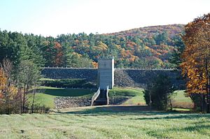
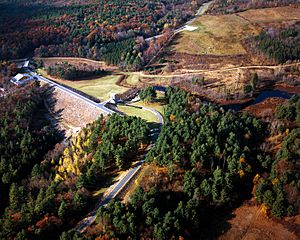
The Barre Falls Dam is a special structure built on the Ware River in Barre, Massachusetts. It's about half a kilometer (0.3 miles) from where the river's east and west branches meet. This dam is also about 21 kilometers (13 miles) northwest of Worcester, Massachusetts.
The United States Army Corps of Engineers designed and built this dam. Its main job is to greatly reduce flooding. It protects areas along the Ware, Chicopee, and Connecticut rivers. Building the dam started in May 1956 and finished in July 1958. It cost about 2 million US dollars.
The area behind the Barre Falls Dam, called the reservoir, is part of the Upper Ware River Watershed. This is also part of the larger Chicopee River Watershed. You can get to the dam easily from Route 62.
What is the Barre Falls Dam Like?
| Barre Falls Dam bridge | |
|---|---|
| Carries | Rueben Walker Road |
| Characteristics | |
| Width | Two lanes |
| Clearance above | Unrestricted |
| Statistics | |
| Daily traffic | < 100 vehicles |
The Barre Falls Dam is made of earth and has stone on its slopes. It is 270 meters (885 feet) long and 21 meters (69 feet) high. There are also three smaller walls, called dikes, which are 980 meters (3,215 feet) long in total. The tallest dike is about 14.6 meters (48 feet) high.
The dam has a special concrete overflow section called a spillway. This spillway is 18.3 meters (60 feet) wide. Its top is 7 meters (23 feet) lower than the very top of the dam.
There isn't a permanent lake at the Barre Falls Dam. Instead, there's a large area that is usually empty. This area is designed to hold floodwaters when there's heavy rain. It covers about 1,500 acres (6 square kilometers). This flood storage area is spread across the towns of Barre, Hubbardston, Rutland, and Oakham, Massachusetts.
The entire project, including all the land around it, covers about 2,407 acres (9.7 square kilometers). The Barre Falls Dam can hold a huge amount of water for flood control. It can store up to 7.82 billion US gallons (29.6 million cubic meters) of water. This is like having 20.8 centimeters (8.2 inches) of water covering its entire drainage area, which is 142.45 square kilometers (55 square miles).
Who Manages the Dam and Land?
The Massachusetts Department of Conservation and Recreation helps to manage and protect the land around the dam. They make sure the water quality stays good. The Massachusetts Water Resources Authority (MWRA) also manages these water resources. This water is an important part of the public water supply for the Greater Boston area.
The Army Corps of Engineers works with the MWRA. They coordinate how much water flows through the dam to help prevent floods. In return, the MWRA helps the Corps by moving extra water when needed for flood control.
You cannot camp, swim, or wade in the water at the Barre Falls Dam. However, there is a fun 18-hole disc golf course. It covers a large part of the area around the dam.
 | Bessie Coleman |
 | Spann Watson |
 | Jill E. Brown |
 | Sherman W. White |


