
Ayer, Massachusetts facts for kids
Quick facts for kids
Ayer, Massachusetts
|
||
|---|---|---|

Main Street
|
||
|
||

Location in Middlesex County in Massachusetts
|
||
| Country | United States | |
| State | Massachusetts | |
| County | Middlesex | |
| Settled | 1668 | |
| Incorporated | February 14, 1871 | |
| Government | ||
| • Type | Open town meeting | |
| Area | ||
| • Total | 9.6 sq mi (24.8 km2) | |
| • Land | 9.0 sq mi (23.4 km2) | |
| • Water | 0.6 sq mi (1.4 km2) | |
| Elevation | 226 ft (69 m) | |
| Population
(2020)
|
||
| • Total | 8,479 | |
| • Density | 883/sq mi (341.9/km2) | |
| Time zone | UTC−5 (Eastern) | |
| • Summer (DST) | UTC−4 (Eastern) | |
| ZIP Code |
01432
|
|
| Area codes | 351/978 | |
| FIPS code | 25-03005 | |
| GNIS feature ID | 0618215 | |
| Website | www.ayer.ma.us | |

Ayer (pronounced AIR) is a town in Middlesex County, Massachusetts, United States. It was once part of Groton. Ayer became its own town on February 14, 1871. It grew into a major center for railroads.
Ayer was home to Camp Stevens, a training camp for soldiers during the American Civil War. Later, Fort Devens was built by the government to train soldiers for World War I. Fort Devens has greatly influenced the area, even though it is much smaller now. In 2020, about 8,479 people lived in Ayer.
Contents
Ayer's History: From Native Americans to Today
Early Native American Life in Ayer
Ayer was first home to the Nashaway people. They were a group of Nipmuc people who lived along the Nashua River. A small village was located near the Nonacoicus Brook in the western part of town. The Nashaway name for the brook, Nunnacoquis, meant 'a small dry earthen pot'. This name might have referred to small mounds along the brook.
Not much old evidence of Native American settlements has been found. This is likely because the land has been farmed and developed over many years. However, some stone tools have been found near the Nashua River and local ponds. These tools show that people lived here long ago. Some parts of Main Street and Sandy Pond Road are thought to follow old trails. Native Americans used these trails for trade and travel.
The Nashaway people grew corn, beans, and squash. They also gathered fruits, nuts, and seeds. They would set up camps in hunting areas during certain seasons. Important gatherings happened when fish like salmon and herring swam up the Nashua River.
European Settlers Arrive
When English settlers arrived in the 1600s, it changed everything for the Native Americans. New diseases like smallpox spread, and Native communities had no protection against them. Many people became sick and died. English settlers also wanted land and resources.
A missionary named John Eliot visited the Nashaway. He taught Native Americans to read and write. Land was set aside for Native American converts in a "Praying Town" called Nashoba. This town was in what is now Littleton, Massachusetts.
In 1675, peace broke between the English and Native Americans during a conflict known as King Philip's War. Many Native Americans who lived in Praying Towns were moved to Deer Island. Many of them did not survive the harsh conditions there. After the war, many Native Americans left the area. Today, some state-recognized Nipmuc tribes are descended from the communities that survived.
How Ayer Was Founded

The town of Groton, which included Ayer, was settled by English colonists around 1655. The first settlement in the area that would become Ayer was in 1667. A mill was built there to serve a small village near the Nonacoicus Brook.
This community was first known as South Groton. When the railroad arrived, it was called Groton Junction. This area later became its own town, Ayer, in 1871. The town was named after Dr. James Cook Ayer. He was a very wealthy medicine maker from Lowell, Massachusetts. Dr. Ayer helped pay for the Town Hall to be built.

A Major Railroad Center
Ayer grew quickly because of the railroads. Even though it is a small town (about 9.5 square miles), it became a major junction for train lines. These lines ran both east-west and north-south. Ayer became an important business center because of the rail industry.
Some of the important railroads that met in Ayer included:
- The Fitchburg Railroad (1844): This line went to Boston and later to New York. It is still used today.
- The Peterborough and Shirley Railroad (1848): This line went north to New Hampshire. Parts of it are still used for freight.
- The Worcester and Nashua Railroad (1848): The southern part of this line still operates. The northern part is now the Nashua River Rail Trail.
- The Stony Brook Railroad (1848): This line went to North Chelmsford, Massachusetts, and is still in use.

Ayer's Military History
During the American Civil War, an army training camp called Camp Stevens was located near the Nashua River. Later, Fort Devens was built in 1917 for World War I. Thousands of military and civilian people lived and worked at the base. This changed Ayer's businesses to serve their needs. Fort Devens closed in 1996 but reopened the next day as a training area for reserve forces. It is now much smaller than it used to be.
The Giant Ski Jump
In 1935, the biggest Nordic ski jump in North America was built in Ayer. It was on Pingry Hill, near a place called the Willows. This huge wooden structure was 700 feet high! It was only used for one winter season. In the summer of 1936, strong winds blew part of it down, and it was never rebuilt. People in the area used some of the wood from the jump. Today, there are no signs left of this massive structure.
Ayer Today
Ayer is a relatively small town but has many businesses. It has plants for companies like Vitasoy and Pepsi. Ayer also has a historic downtown area. You can take the commuter train from Ayer to Boston.
Ayer's Geography
Ayer covers about 9.6 square miles (24.8 square kilometers). Most of this area, about 9.0 square miles (23.4 square kilometers), is land. The rest, about 0.6 square miles (1.4 square kilometers), is water.
Ayer shares its borders with the towns of Shirley, Groton, Littleton, and Harvard.
Ayer's Population
| Historical population | ||
|---|---|---|
| Year | Pop. | ±% |
| 1900 | 2,446 | — |
| 1910 | 2,797 | +14.3% |
| 1920 | 3,052 | +9.1% |
| 1930 | 3,060 | +0.3% |
| 1940 | 3,572 | +16.7% |
| 1950 | 5,740 | +60.7% |
| 1960 | 14,927 | +160.1% |
| 1970 | 8,325 | −44.2% |
| 1980 | 6,993 | −16.0% |
| 1990 | 6,871 | −1.7% |
| 2000 | 7,287 | +6.1% |
| 2010 | 7,427 | +1.9% |
| 2020 | 8,479 | +14.2% |
| 2023* | 8,546 | +0.8% |
| * = population estimate. | ||
In 2010, there were 7,427 people living in Ayer. There were 3,118 households and 1,831 families. The town had about 825 people per square mile.
About 22.6% of the people were under 18 years old. The average age in Ayer was 38.2 years. For every 100 females, there were about 101 males.
Ayer's Economy
Ayer is home to some businesses. For example, Vitasoy had its main North American office here for a few years. It is now a regional office for the company.
Education in Ayer
Public Schools
Ayer and the nearby town of Shirley share a school district called the Ayer Shirley Regional School District.
- Page Hilltop Elementary School
- Ayer Shirley Regional Middle School
- Ayer Shirley Regional High School
Ayer is also home to the Francis W. Parker Charter Essential School.
Colleges
After World War II, the army base at Fort Devens was used as a temporary college campus. This college, Massachusetts State College–Fort Devens, was open for three years. It closed in 1949.
Transportation in Ayer
The Montachusett Regional Transit Authority (MART) provides public transportation in Ayer. The MBTA Commuter Rail's Fitchburg Line offers train service to North Station in Boston from Ayer station.
Ayer is located on major roads like Route 2A, Route 110, and Route 111. It is also close to Interstate 495 and Route 2.
Freight trains travel through Ayer every day on the tracks of the old Stony Brook Railroad. This line is an important route for Pan Am Railway's trains.
The southern part of the Nashua River Rail Trail starts in Ayer. This trail is great for walking and biking.
Places to Visit in Ayer
Several places in Ayer are listed on the National Register of Historic Places. This means they are important historical sites.
- Community Memorial Hospital – 15 Winthrop Ave.
- Fort Devens Historic District
- Ayer Main Street Historic District – Main St.
- Pleasant Street School – Pleasant St.
- St. Andrew's Church (1892) – 7 Faulkner St.
The Billiards Cafe on Main Street in Ayer has something special: the only full-sized snooker table in New England. It measures 6 feet by 12 feet!
Notable People from Ayer
- Lee Alexander, a bassist
- Bill Aucoin, who managed the band Kiss
- Foster Ellenborough Lascelles Beal, a naturalist
- C. L. Blood, a con artist
- Rita Briggs, a female baseball catcher in the All-American Girls Professional League
- Angus Dun, a vicar at St. Andrew's Episcopal Church
- Robert Frazier, a writer of science fiction and poetry
- Mike Gillian, a college basketball coach
- Jamie Morris, a National Football League running back
- Joe Morris, a National Football League running back
- Betty Anne Waters, a lawyer
- Norbert Wiener, a child genius who graduated from Ayer High School at age 11 and became a famous engineer and computer theorist
Images for kids
-
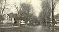
East Main Street around 1906
-
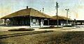
Postcard view showing the two railroad stations that once served Ayer, dated 1910
See also
 In Spanish: Ayer (Massachusetts) para niños
