Bolton, Massachusetts facts for kids
Quick facts for kids
Bolton, Massachusetts
|
|||
|---|---|---|---|

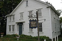
Sawyer House, Bolton Historical Society
|
|||
|
|||

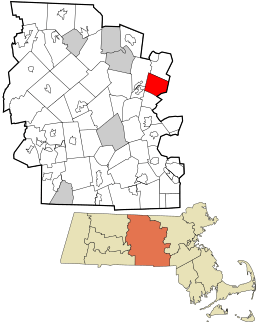
Location in Worcester County and the state of Massachusetts.
|
|||
| Country | United States | ||
| State | Massachusetts | ||
| County | Worcester | ||
| Settled | 1682 | ||
| Incorporated | 1738 | ||
| Government | |||
| • Type | Open town meeting | ||
| Area | |||
| • Total | 20.0 sq mi (51.8 km2) | ||
| • Land | 19.9 sq mi (51.6 km2) | ||
| • Water | 0.1 sq mi (0.2 km2) | ||
| Elevation | 387 ft (118 m) | ||
| Population
(2020)
|
|||
| • Total | 5,665 | ||
| • Density | 283.3/sq mi (109.36/km2) | ||
| Time zone | UTC-5 (Eastern) | ||
| • Summer (DST) | UTC-4 (Eastern) | ||
| ZIP code |
01740
|
||
| Area code(s) | 351 / 978 | ||
| FIPS code | 25-06365 | ||
| GNIS feature ID | 0618357 | ||
| Website | www.townofbolton.com | ||
Bolton is a charming town in Worcester County, Massachusetts, USA. It's located in central Massachusetts, about 25 miles west of Boston. Bolton is part of the larger Greater Boston area. In 2020, about 5,665 people lived here.
The town was settled in the 1600s and officially became a town in 1738. Today, Bolton is known for its many farms and apple orchards. You can also find the famous Nashoba Valley Winery and The International Golf Club here. This golf club has even hosted big tournaments! Bolton is also home to the Bolton Flats Wildlife Management Area near the Nashua River and Still River, along with other beautiful parks.
Contents
History of Bolton
Before Bolton became a town, English farmers settled here in the 1600s. They lived near the Nashaway tribe, who fished and farmed along the Nashua River. In 1643, Thomas King bought this land from the Nashaway leader, Sholan.
The land that is now Bolton was once part of the town of Lancaster. Bolton separated from Lancaster along the Still River. This river still marks the boundary today. Bolton officially became a town on June 24, 1738. It was named after the Duke of Bolton.
In 1656, a road called the Concord highway was built over Wattaquadock Hill in Bolton. By 1711, over 150 people lived in Bolton. Early houses were often built like small forts, called "garrisons," for protection. After a period of conflicts, various small businesses started in Bolton. These included mining limestone at the Bolton Lime Kiln and Quarry.
During the American Revolution, Bolton farmers strongly supported the fight for independence. They even put up a "liberty pole" in the town center. General John Whitcomb from Bolton was a key leader. He was a minuteman at the Battles of Lexington and Concord and the Battle of Bunker Hill.
By the 1860s, during the American Civil War, Bolton residents formed a group against slavery. Twenty-one Bolton residents bravely fought and died for the Union. The Bolton Fair started in Bolton in 1874 as a farming fair. However, the fairgrounds moved to nearby Lancaster in 2004, where it is still held every year.
Bolton's Geography
Bolton covers about 20 square miles (51.8 square kilometers). Most of this area is land, with a small amount of water. The highest points in Bolton are Wattaquadock Hill and Vaughn Hill's North Peak.
People of Bolton
| Historical population | ||
|---|---|---|
| Year | Pop. | ±% |
| 1850 | 1,263 | — |
| 1860 | 1,348 | +6.7% |
| 1870 | 1,014 | −24.8% |
| 1880 | 903 | −10.9% |
| 1890 | 827 | −8.4% |
| 1900 | 770 | −6.9% |
| 1910 | 764 | −0.8% |
| 1920 | 708 | −7.3% |
| 1930 | 764 | +7.9% |
| 1940 | 775 | +1.4% |
| 1950 | 956 | +23.4% |
| 1960 | 1,264 | +32.2% |
| 1970 | 1,905 | +50.7% |
| 1980 | 2,530 | +32.8% |
| 1990 | 3,134 | +23.9% |
| 2000 | 4,148 | +32.4% |
| 2010 | 4,897 | +18.1% |
| 2020 | 5,665 | +15.7% |
| 2023* | 5,738 | +1.3% |
| * = population estimate. Source: United States Census records and Population Estimates Program data. |
||
In 2010, there were 4,897 people living in Bolton. Most residents were White (94.9%). About 2.7% were Asian, and 0.5% were African American. About 1.8% of the population identified as Hispanic or Latino.
Many households (43.7%) had children under 18 living with them. The average household had about 2.93 people. The median age in Bolton was 38 years old. About 31.2% of the population was 19 or younger.
In 2015, the average income for a household in Bolton was around $147,446. For families, it was about $155,063. This means Bolton is a town with a good economy. Only a small number of families (1.3%) and people (1.8%) lived below the poverty line.
Arts and Culture in Bolton
Bolton has several places listed on the National Register of Historic Places. These are important sites that help us remember the past.
Historic Places to Visit
- Bolton Center Historic District: This area includes old civic, religious, and business buildings.
- Pan Burying Ground: This cemetery was established in 1822. It has a unique group tomb with seven chambers.
- Pan Historic District: Here you can see many old homes built in the Federal style and colonial architecture.
- Whitcomb Inn and Farm: Built around 1708, this might be the oldest house still standing in Bolton.
Education in Bolton
Bolton is part of the Nashoba Regional School District. This district also serves the towns of Lancaster and Stow.
Schools in Bolton
- Florence Sawyer School: This school teaches students from Pre-Kindergarten to 8th grade.
- Nashoba Regional High School: This is the high school for students from Bolton and the other towns in the district.
Famous People from Bolton
Many interesting people have connections to Bolton! Here are a few:
- Suzy Becker (born 1962): An author, illustrator, and social activist.
- Bill Ezinicki (1924–2012): A professional hockey player who won three Stanley Cups. He was also a professional golfer.
- Hal Gill (born 1975): A former NHL hockey player.
- William Ellery Leonard (1876–1944): A poet and author who was a professor at the University of Wisconsin.
- Amos Nourse (1794–1877): Served as a United States Senator from Maine.
- Karen O'Connor (born 1958): An American equestrian who competes in three-day eventing.
- Philip J. Philbin (1898–1972): A member of the United States House of Representatives for many years.
- Wilbert Robinson (1864–1934): A famous Baseball Hall of Fame manager, nicknamed "Uncle Robbie." He managed the Brooklyn Dodgers for 17 years.
- Frederick A. Sawyer (1822–1891): Served as a United States Senator from South Carolina.
- John Whitcomb (1713–1785): A state representative and general during the American Revolutionary War.
See also
 In Spanish: Bolton (Massachusetts) para niños
 | Kyle Baker |
 | Joseph Yoakum |
 | Laura Wheeler Waring |
 | Henry Ossawa Tanner |


