Tonawanda Creek facts for kids
Quick facts for kids Tonawanda Creek |
|
|---|---|

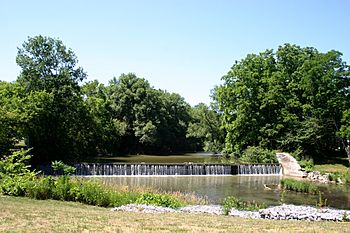
Old mill dam at the Big Bend of Tonawanda Creek, downtown Batavia, New York
|
|
|
Location of the mouth of the Tonawanda Creek in New York State
|
|
| Country | United States |
| State | New York |
| Counties | Wyoming, Genesee, Erie, Niagara |
| Physical characteristics | |
| Main source | Town of Java, Wyoming County 42°39′29″N 78°19′09″W / 42.65806°N 78.31917°W |
| River mouth | Niagara River City of Tonawanda 43°01′25″N 78°52′54″W / 43.02361°N 78.88167°W |
| Length | 90 mi (140 km) |
| Basin features | |
| Progression | Niagara River→ Lake Ontario→ Saint Lawrence River→ Gulf of Saint Lawrence |
| Basin size | 650 sq mi (1,700 km2) |
Tonawanda Creek is a small river in Western New York, United States. It flows into the Niagara River. The creek starts in Wyoming County. Then it flows through Genesee County. Finally, it forms part of the border between Erie County and Niagara County.
Contents
About Tonawanda Creek
Tonawanda Creek is about 90 miles (140 km) (145 km) long. The area of land that drains into it, called its drainage basin, is nearly 650 square miles (1,700 km2) (1,683 km²) big. The creek twists and turns a lot along its path. It first flows north until it reaches the City of Batavia. There, it makes a big turn and flows west.
The creek begins in Wyoming County. It ends when it flows into the Niagara River. This happens between Niagara County and Erie County. The creek acts as a natural border between these two counties.
Tonawanda Creek flows past several towns and cities. These include the Village of Attica and the City of Batavia. It also flows between the City of North Tonawanda to the north and the Town of Amherst to the south. Other places it passes are the Town of Clarence, the Town of Tonawanda, and the City of Tonawanda. Just after another creek called Ellicott Creek joins it, Tonawanda Creek enters the Niagara River.
Indian Falls Waterfall
The creek has a small waterfall at a place called Indian Falls. This waterfall is about 30-foot-high (9.1 m). Here, the water drops down from a rock formation known as the Onondaga Escarpment.
Flooding
Every spring, some parts of Tonawanda Creek can flood. These floods are usually not too serious. However, they can become more dangerous if ice gets stuck and blocks the water. Larger floods can sometimes cause damage to buildings and other property.
Erie Canal Connection
Tonawanda Creek is also an important part of the Erie Canal. The canal connects with the creek southwest of Lockport. This allows boats and barges to travel from the canal into the Niagara River. In its upper parts, Tonawanda Creek and a smaller stream called Little Tonawanda Creek are good places to find trout fish.
History of Tonawanda Creek
The name Tonawanda comes from the Iroquois (Haudenosaunee) language. It means "swift water." The Iroquois are a group of Native American tribes.
Ancient Lake Tonawanda
Tonawanda Creek flows through an old lake bed. This area was once part of Glacial Lake Tonawanda. This ancient lake existed about 10,000 years ago. That was at the end of the last ice age. Many of the swampy areas around Tonawanda Creek today are left over from this old lake.
Historical Marker
Downstream from Indian Falls, Tonawanda Creek flows through the Tonawanda Indian Reservation. There is a special historical marker here. It shows where George Washington led his troops across the stream a long time ago.
Erie Canal Water Source
When the Erie Canal was first built, Tonawanda Creek was very important. It was the main source of water for the western part of the canal.
 | Shirley Ann Jackson |
 | Garett Morgan |
 | J. Ernest Wilkins Jr. |
 | Elijah McCoy |


