Batavia, New York facts for kids
Quick facts for kids
Batavia
|
|
|---|---|
|
City
|
|
|
|
| Nickname(s):
1802 Birthplace of Western New York
|
|
| Motto(s):
“The Right Place. The Right Time.”
|
|
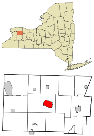
Location within Genesee County and New York
|
|
| Country | |
| State | |
| County | Genesee |
| Founded (village) | 1802 |
| Incorporated (village) | 1823 |
| Named for | Batavia, Netherlands |
| Government | |
| • Type | Council-Manager |
| Area | |
| • Total | 5.28 sq mi (13.67 km2) |
| • Land | 5.20 sq mi (13.46 km2) |
| • Water | 0.08 sq mi (0.21 km2) 1.14% |
| Elevation | 892 ft (272 m) |
| Population
(2020)
|
|
| • Total | 15,600 |
| • Density | 3,002.89/sq mi (1,159.33/km2) |
| Time zone | UTC−5 (EST) |
| • Summer (DST) | UTC−4 (EDT) |
| ZIP Code |
14020
|
| Area code | 585 |
| FIPS code | 36-04715 |
| GNIS feature ID | 0943150 |
| Website | Batavia NY |
Batavia is a city in New York State. It's the main city, or "county seat," of Genesee County. It's located in the middle of the county, surrounded by the Town of Batavia, which is a different local government. In 2020, about 15,600 people lived in Batavia. It's part of a larger area that includes Rochester and Seneca Falls.
The name Batavia comes from a Latin word for a region in the Netherlands. This name honors the early Dutch people who helped develop the land. In 2006, a national magazine called Site Selection ranked Batavia as one of the top small cities for economic growth. The New York State Thruway (a major highway) passes north of the city. The Genesee County Airport is also north of Batavia.
The city is home to the Batavia Muckdogs baseball team. They play at Dwyer Stadium. The Muckdogs are part of the Perfect Game Collegiate Baseball League. They used to be connected with the Miami Marlins and won a championship in 2008.
Contents
History of Batavia
How Batavia Was Founded
The city of Batavia was one of the first settlements in what is now called Genesee Country. This is the far western part of New York State. A group of Dutch bankers, called the Holland Land Company, bought a huge piece of land here in the late 1790s. It was about 3.25 million acres (13,150 square kilometers)!
The village of Batavia was started in 1802 by Joseph Ellicott. He worked for the Holland Land Company. The name Batavia was chosen to honor the Batavian Republic, which was a government in the Netherlands, where the investors of the land company were from.
Before the land could be sold, the Native American tribes, mainly the Senecas, needed to agree to the sale. In 1797, a deal was made at the Treaty of Big Tree. The Seneca tribe sold most of their land rights for $100,000. Mary Jemison, known as The White Woman of the Genesee, helped the tribe get better terms in the deal.
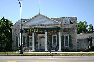
Joseph Ellicott set up a land office in Batavia in 1802. This office was where all the land in the area was sold. The entire region was named Genesee County, and Batavia became its main city. The Holland Land Company sold off all the land by 1846. The saying "doing a land office business" (meaning doing very well) comes from this time! Ellicott lived in Batavia for many years. Today, a main street and a monument in Batavia are named after him. Batavia officially became a village in 1823.
Over time, many other counties in western New York were created from the original Genesee County. But the whole area is still often called Genesee Country. This means Batavia was key to opening up western New York for new settlers and growth.
Growth and Industry
When the Erie Canal was built in 1825, it didn't go through Batavia. Instead, it went north through towns like Albion and Medina. This helped cities like Buffalo and Rochester grow much faster. After the land was sold, Batavia became a smaller city known for its factories. It made things like tractors, farm tools, and shoes. It was also a center for making special tools for other industries.
The biggest factory was the Johnston Harvester Company, started in 1868. In 1910, a Canadian company called Massey-Harris Co. Ltd bought it.
Batavia grew quickly in the early 1900s, with many people moving there from Poland and Italy. Batavia officially became a city in 1915.
What Has Happened Recently?
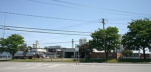
Batavia is part of what's known as the Rust Belt. This means that in recent years, many of the big factories and heavy industries have moved away. Because of this, the number of people living in the city has slowly gone down since 1960.
However, new jobs have been created. A federal immigration center, the Buffalo Federal Detention Facility, was built near the airport. The airport itself also expanded in 2005, with a longer runway for bigger planes.
In 2012, a large yogurt factory, Muller Quaker Dairy, started being built. It created 170 jobs by 2015. However, the factory closed in December 2015 and was sold to another company, Dairy Farmers of America.
Geography and Weather
Where is Batavia Located?
The city of Batavia covers about 5.2 square miles (13.6 square kilometers). Most of this is land, with a small amount of water. The city is also located right along the 43rd parallel north line on a map.
Major roads like New York State Route 5 (which goes east-west) cross with other state routes (33, 63, and 98) in the city. The New York State Thruway (a major highway) is just north of Batavia.
What is Batavia's Climate Like?
Batavia has a climate with big changes in temperature throughout the year. Summers are warm to hot and often humid. Winters are cold, sometimes very cold. This type of weather is called a humid continental climate.
| Climate data for Batavia, New York, 1991–2020 normals, extremes 1932–present | |||||||||||||
|---|---|---|---|---|---|---|---|---|---|---|---|---|---|
| Month | Jan | Feb | Mar | Apr | May | Jun | Jul | Aug | Sep | Oct | Nov | Dec | Year |
| Record high °F (°C) | 72 (22) |
74 (23) |
81 (27) |
92 (33) |
93 (34) |
95 (35) |
103 (39) |
96 (36) |
96 (36) |
88 (31) |
79 (26) |
73 (23) |
103 (39) |
| Mean maximum °F (°C) | 56.5 (13.6) |
54.5 (12.5) |
65.7 (18.7) |
78.4 (25.8) |
85.1 (29.5) |
88.3 (31.3) |
89.8 (32.1) |
88.0 (31.1) |
85.9 (29.9) |
78.1 (25.6) |
68.1 (20.1) |
57.5 (14.2) |
91.0 (32.8) |
| Mean daily maximum °F (°C) | 31.0 (−0.6) |
33.1 (0.6) |
42.4 (5.8) |
55.7 (13.2) |
67.9 (19.9) |
76.4 (24.7) |
80.0 (26.7) |
78.5 (25.8) |
72.4 (22.4) |
60.0 (15.6) |
47.6 (8.7) |
36.2 (2.3) |
56.8 (13.8) |
| Daily mean °F (°C) | 23.4 (−4.8) |
24.9 (−3.9) |
33.4 (0.8) |
45.3 (7.4) |
57.3 (14.1) |
66.3 (19.1) |
70.4 (21.3) |
68.9 (20.5) |
62.4 (16.9) |
50.9 (10.5) |
39.7 (4.3) |
29.3 (−1.5) |
47.7 (8.7) |
| Mean daily minimum °F (°C) | 15.8 (−9.0) |
16.6 (−8.6) |
24.3 (−4.3) |
34.9 (1.6) |
46.7 (8.2) |
56.1 (13.4) |
60.7 (15.9) |
59.3 (15.2) |
52.4 (11.3) |
41.8 (5.4) |
31.8 (−0.1) |
22.3 (−5.4) |
38.6 (3.6) |
| Mean minimum °F (°C) | −3.3 (−19.6) |
−2.2 (−19.0) |
6.3 (−14.3) |
22.3 (−5.4) |
33.9 (1.1) |
44.0 (6.7) |
50.4 (10.2) |
48.9 (9.4) |
39.7 (4.3) |
29.1 (−1.6) |
18.1 (−7.7) |
4.8 (−15.1) |
−7.2 (−21.8) |
| Record low °F (°C) | −24 (−31) |
−28 (−33) |
−15 (−26) |
6 (−14) |
24 (−4) |
32 (0) |
40 (4) |
33 (1) |
28 (−2) |
19 (−7) |
1 (−17) |
−18 (−28) |
−28 (−33) |
| Average precipitation inches (mm) | 2.47 (63) |
1.90 (48) |
2.43 (62) |
3.17 (81) |
3.23 (82) |
3.69 (94) |
3.53 (90) |
3.25 (83) |
3.62 (92) |
3.60 (91) |
2.92 (74) |
2.76 (70) |
36.57 (930) |
| Average snowfall inches (cm) | 23.0 (58) |
18.6 (47) |
11.4 (29) |
1.7 (4.3) |
0.0 (0.0) |
0.0 (0.0) |
0.0 (0.0) |
0.0 (0.0) |
0.0 (0.0) |
0.4 (1.0) |
5.8 (15) |
13.0 (33) |
73.9 (187.3) |
| Average extreme snow depth inches (cm) | 8.2 (21) |
9.8 (25) |
8.5 (22) |
1.3 (3.3) |
0.0 (0.0) |
0.0 (0.0) |
0.0 (0.0) |
0.0 (0.0) |
0.0 (0.0) |
0.3 (0.76) |
3.6 (9.1) |
9.1 (23) |
15.9 (40) |
| Average precipitation days (≥ 0.01 in) | 14.8 | 12.1 | 11.7 | 13.4 | 12.5 | 11.7 | 10.9 | 10.4 | 11.9 | 14.6 | 12.4 | 14.1 | 150.5 |
| Average snowy days (≥ 0.1 in) | 9.2 | 6.5 | 3.5 | 0.9 | 0.0 | 0.0 | 0.0 | 0.0 | 0.0 | 0.1 | 1.3 | 5.1 | 26.6 |
| Source 1: NOAA | |||||||||||||
| Source 2: National Weather Service | |||||||||||||
People of Batavia
How Many People Live Here?
| Historical population | |||
|---|---|---|---|
| Census | Pop. | %± | |
| 1810 | 100 | — | |
| 1830 | 1,671 | — | |
| 1840 | 2,000 | 19.7% | |
| 1850 | 3,000 | 50.0% | |
| 1860 | 2,868 | −4.4% | |
| 1870 | 3,890 | 35.6% | |
| 1880 | 4,845 | 24.6% | |
| 1890 | 7,221 | 49.0% | |
| 1900 | 9,180 | 27.1% | |
| 1910 | 11,613 | 26.5% | |
| 1920 | 13,541 | 16.6% | |
| 1930 | 17,375 | 28.3% | |
| 1940 | 17,267 | −0.6% | |
| 1950 | 17,799 | 3.1% | |
| 1960 | 18,210 | 2.3% | |
| 1970 | 17,338 | −4.8% | |
| 1980 | 16,703 | −3.7% | |
| 1990 | 16,310 | −2.4% | |
| 2000 | 16,256 | −0.3% | |
| 2010 | 15,465 | −4.9% | |
| 2020 | 15,600 | 0.9% | |
| U.S. Decennial Census | |||
In 2010, there were 15,465 people living in Batavia. There were 6,644 households and 3,710 families. The mix of different racial groups in the city changed a little between 2000 and 2010.
In 2000, there were 16,256 people. Most residents (90.23%) were White. About 5.43% were Black or African American, and smaller percentages were Native American, Asian, or from other backgrounds. About 2.45% of the population was Hispanic or Latino.
The average household had 2.34 people, and the average family had 3.01 people. About 23.4% of the city's population was under 18 years old. The median age was 38 years. The median income for a household was $33,484. About 12.3% of the population lived below the poverty line.
Education in Batavia
The Batavia City School District runs the public schools in the city. This includes Batavia High School.
Batavia is also home to the New York State School for the Blind. This is a special school for students from kindergarten to 12th grade who are blind or visually impaired. The main campus of Genesee Community College is also located here.
Cool Facts and Events
- The first "business incubator" in the United States started in Batavia. A business incubator helps new businesses grow by giving them support and resources.
- John Elway, a famous football quarterback, hit his first professional home run in baseball at Dwyer Stadium in Batavia.
- In March 1926, over 1,000 people came to hear Helen Keller speak at the high school.
- On September 3, 1993, a tornado hit Batavia.
- On August 3, 1994, an Amtrak train called the Lake Shore Limited went off its tracks near Batavia. No one died in the accident.
- Governor George Pataki made Batavia the New York State "Capital for A Day" on July 25, 2001. This meant the state government worked from Batavia for one day.
- Batavia was used as a place to film parts of the 1987 comedy movie, Planes, Trains and Automobiles.
Famous People From Batavia
Many interesting people have connections to Batavia:
- Terry A. Anderson, a journalist who was held captive in Lebanon.
- Thom Beers, a TV producer.
- David Bellavia, an Iraq War veteran.
- Albert Brisbane, a writer and newspaper publisher.
- Barber Conable, a political leader and former president of the World Bank.
- Marc Ferrari, a guitar player for the band Keel.
- John Gardner, a novelist and professor.
- Mary Jemison, known as The White Woman of the Genesee, who helped Native American tribes in land negotiations.
- Bill Kauffman, a political journalist and author.
- William Morgan, whose book and disappearance led to a movement against Freemasonry.
- J. C. Tretter, an NFL player.
- Emory Upton, a United States Army General during the Civil War.
- Edward J. York, a United States Air Force colonel who took part in the Doolittle Raid during World War II.
Images for kids
-
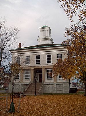
The Genesee County Courthouse in Batavia.
-
A map showing Batavia's location in Genesee County.
-
The old office of the Holland Land Company, now a museum.
See also
 In Spanish: Batavia (Nueva York) para niños
 | Janet Taylor Pickett |
 | Synthia Saint James |
 | Howardena Pindell |
 | Faith Ringgold |


