
West Seneca, New York facts for kids
Quick facts for kids
West Seneca, New York
Seneca
|
||
|---|---|---|

West Seneca town hall, July 2022
|
||
|
||
| Motto(s):
"Proud Past — Unlimited Future" |
||

Location in Erie County and the state of New York
|
||
| Country | United States | |
| State | New York | |
| County | Erie | |
| Founded as the Village of Ebenezer | 1842 | |
| As Seneca | 1851 | |
| As West Seneca | 1852 | |
| Named for | Seneca Nation | |
| Government | ||
| • Type | Town Council | |
| Area | ||
| • Total | 21.41 sq mi (55.46 km2) | |
| • Land | 21.36 sq mi (55.31 km2) | |
| • Water | 0.06 sq mi (0.15 km2) | |
| Elevation | 643 ft (196 m) | |
| Population
(2020)
|
||
| • Total | 45,500 |
|
| • Density | 2,128.72/sq mi (821.89/km2) | |
| Time zone | UTC-5 (Eastern (EST)) | |
| • Summer (DST) | UTC-4 (EDT) | |
| Area code(s) | 716 | |
| FIPS code | 36-029-80918 | |
| GNIS feature ID | 0979626 | |

West Seneca is a town in Erie County, New York, United States. It's like a smaller community (a suburb) near the big city of Buffalo. In 2020, about 45,500 people lived there. West Seneca is part of a group of towns called the "Southtowns". These towns are known for being nice suburban areas.
Contents
History of West Seneca
The land where West Seneca is located was once part of the Buffalo Creek Reservation. This means it was land set aside for Native American tribes. It wasn't open for white settlers until the mid-1800s.
In 1851, a town called "Seneca" was created. It was made from parts of the towns of Cheektowaga and Hamburg. The next year, in 1852, the town changed its name to "West Seneca." This was to avoid confusion with another town named Seneca in a different county. Later, in 1909, the area just south of Buffalo separated from West Seneca. This area then became the city of Lackawanna.
Two important historical places in West Seneca are the Eaton Site and the Community of True Inspiration Residence. The Eaton Site was added to the National Register of Historic Places in 1979. The Community of True Inspiration Residence was added in 2013.
Geography and Location
West Seneca covers about 55.46 square kilometers (around 21.41 square miles). Most of this area is land, with a small amount of water.
The New York State Thruway (which is Interstate 90) goes through West Seneca. Other major roads include New York State Route 400 and U.S. Route 219. The eastern border of the town is marked by New York State Route 78 (Transit Road). Other important roads that run north-south are New York State Route 240 and New York State Route 277. Major east-west roads include New York State Route 16 and New York State Route 354.
Neighboring Towns and Cities
West Seneca is surrounded by several other towns and cities:
- Town of Cheektowaga - to the north
- City of Buffalo - to the northwest
- City of Lackawanna - to the west
- Town of Hamburg - to the southwest
- Town of Orchard Park - to the south
- Town of Elma - to the east
- Town of Lancaster - to the northeast
Main Roads in West Seneca

 Interstate 90 (also known as the New York State Thruway) travels through the western part of town.
 U.S. Route 219 (Southern Expressway) is a north-south road that goes through the very southwestern part of town. It connects to I-90.
 U.S. Route 20 (Transit Road, Southwestern Boulevard) forms part of the eastern border of the town.
 New York State Route 16 (Seneca Street, Center Road) goes through the town from east to west.
 New York State Route 78 (Transit Road) marks the eastern town line.
 New York State Route 240 (Harlem Road, Orchard Park Road) is a north-south road through town.
 New York State Route 277 (Union Road) is another north-south highway.
 New York State Route 354 (Clinton Street) is an east-west road in the northern part of town.
 New York State Route 400 (Aurora Expressway) is an east-west highway that starts at I-90.
Communities and Important Places
- Buffalo Airfield (9G0) – A small airport located on the northern border of the town.
- Buffalo Creek – A stream that flows west through the town. The city of Buffalo gets its name from this stream.
- East Seneca – A place located on Route 16 in the eastern part of town.
- Ebenezer – A central area named after the Ebenezer Society. This was a group of German Lutherans who settled here around 1843.
- Gardenville – A small community (a hamlet) on the northern border, shared with the town of Cheektowaga.
- New Ebenezer – Another small community east of Gardenville.
- West Seneca Census-Designated Place – This is a special area used for census data that covers the entire town of West Seneca.
Population and People
| Historical population | |||
|---|---|---|---|
| Census | Pop. | %± | |
| 1850 | 2,523 | — | |
| 1860 | 2,784 | 10.3% | |
| 1870 | 3,196 | 14.8% | |
| 1880 | 3,463 | 8.4% | |
| 1890 | 3,485 | 0.6% | |
| 1900 | 5,363 | 53.9% | |
| 1910 | 4,605 | −14.1% | |
| 1920 | 7,062 | 53.4% | |
| 1930 | 10,401 | 47.3% | |
| 1940 | 12,694 | 22.0% | |
| 1950 | 17,417 | 37.2% | |
| 1960 | 33,644 | 93.2% | |
| 1970 | 48,404 | 43.9% | |
| 1980 | 51,210 | 5.8% | |
| 1990 | 47,830 | −6.6% | |
| 2000 | 45,920 | −4.0% | |
| 2010 | 44,711 | −2.6% | |
| 2020 | 45,500 | 1.8% | |
| Historical Population Figures | |||
In 2010, there were 44,711 people living in West Seneca. There were 19,151 households, which are groups of people living together. The average household had about 2.47 people.
Most people in West Seneca are White (about 97.96%). Other groups include Black or African American (0.85%), Native American (0.21%), and Asian (0.62%). About 1.67% of the population was Hispanic or Latino.
In 2000, about 22.3% of the people were under 18 years old. The median age was 41 years. This means half the people were younger than 41, and half were older.
Fun Things to Do
The Charles E. Burchfield Nature & Art Center is a great place to visit in West Seneca. It opened in 1999 and covers 29 acres. This center combines art and nature. It has wild and cultivated gardens, a large playground, and nature trails. There's also an outdoor amphitheater next to the Buffalo Creek.


West Seneca was once home to one of the biggest malls in the area, called the Seneca Mall.
Schwabl's is a famous restaurant that has been in West Seneca since 1837. It's known for its "beef on weck" sandwich. The restaurant was even shown on a TV show called Anthony Bourdain: No Reservations in 2009.
The XGen Elite Sports Complex is where the Buffalo eXtreme basketball team plays. They are part of the American Basketball Association.
Schools and Learning
West Seneca has three different public school districts. The West Seneca Central School District is the largest. It serves most of the town. It also includes small parts of nearby towns like Cheektowaga, Orchard Park, and Hamburg. Other parts of West Seneca are served by the Orchard Park Central School District and the Cheektowaga-Sloan Union Free School District.
There are also several private schools in West Seneca:
- Queen of Heaven School
- The Center Road Christian Academy
- Trinity Christian School
- St. John Vianney School
- West Seneca Christian School
Some schools that used to be in West Seneca have closed. These include Fourteen Holy Helpers School and Our Lady of the Sacred Heart School. Houghton College also used to have a campus here.
Famous People from West Seneca
Many notable people have connections to West Seneca:
- Matt Anderson – A professional volleyball player.
- Jordan Buckley, Keith Buckley, and Stephen Micciche – Members of the rock band Every Time I Die.
- Charles E. Burchfield – A famous painter and visionary artist who lived in West Seneca for 42 years.
- Vincent J. Graber Sr. – A former New York State Assemblyman.
- Jeremy Kelley – An NFL wide receiver.
- Christian Metz – An Inspirationalist who helped start the community of Ebenezer.
- Aaron Miller – A former NHL ice hockey player who grew up in West Seneca.
- Chris Mueller – An NHL ice hockey player who grew up in West Seneca.
- Tina Parol – A singer-songwriter.
- Brian Roloff – A professional hockey player.
- Tim Russert – A well-known NBC journalist who went to elementary school in West Seneca.
- Lee Stempniak – A former NHL ice hockey player who grew up in West Seneca.
- Justin Strzelczyk – A former NFL player who grew up in West Seneca.
- Robby Takac – The bassist for the band Goo Goo Dolls.
- Sandra Lee Wirth – A former New York State Assemblywoman.
- Brian Daboll – The head coach of the NFL's New York Giants.
Gallery
-
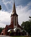
Fourteen Holy Helpers Church
-
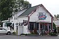
Schwabls Restaurant


Related Links
- West Seneca Central School District serves West Seneca and parts of Cheektowaga, Orchard Park and Hamburg.
See also
 In Spanish: West Seneca (Nueva York) para niños
