Cattaraugus Creek facts for kids
Quick facts for kids Cattaraugus Creek |
|
|---|---|

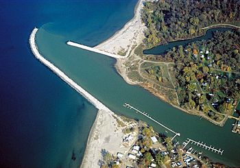
The mouth of Cattaraugus Creek on Lake Erie near Sunset Bay, New York.
|
|
|
Location of the mouth of Cattaraugus Creek in New York State.
|
|
| Country | United States |
| State | New York |
| Physical characteristics | |
| Main source | Java Lake Java, Wyoming County 42°37′43″N 78°20′24″W / 42.62861°N 78.34000°W |
| River mouth | Lake Erie Sunset Bay, Erie County 42°34′14″N 79°08′14″W / 42.57056°N 79.13722°W |
| Length | 68 mi (109 km) |
| Basin features | |
| Basin size | 559 sq mi (1,450 km2) |
Cattaraugus Creek is a stream in western New York State, about 68 miles (109 km) long. It flows through forests and countryside southwest of Buffalo. The creek eventually empties into Lake Erie.
A large part of its lower section flows through the Cattaraugus Reservation. This is land belonging to the Seneca tribe. The name Cattaraugus comes from the Seneca word Gah-ta-ra-ke-ras. It means "stinking shore" or "foul-smelling river bank." This name likely comes from natural gas that sometimes bubbles up from the river mud.
Contents
Where Does Cattaraugus Creek Flow?
The creek starts at Java Lake in Wyoming County. In the village of Arcade, another stream called Clear Creek joins it. It then flows west, forming the border between Erie County and Cattaraugus County.
Near Springville, the creek reaches the Scoby Dam. From Springville to Gowanda, the creek flows through the Zoar Valley Multiple Use Area. This area is a popular spot for fishing and rafting. The South Branch of Cattaraugus Creek also joins the main creek near Gowanda. Finally, Cattaraugus Creek flows into Lake Erie near Sunset Bay.
Fishing for Steelhead Trout
Every year, usually in October and November, many people come to Cattaraugus Creek to fish. They are hoping to catch steelhead trout. These fish swim upstream from Lake Erie to lay their eggs.
Right now, the Scoby Dam stops the steelhead from swimming further upstream. However, there's a plan to make the dam lower and add a fish ladder. A fish ladder is like a set of steps that fish can use to get past a dam. If this plan happens, steelhead could swim into an extra 44 miles (71 km) of the creek! This would open up many new places for anglers (people who fish) to enjoy.
Allowing steelhead to reach more areas could also help them reproduce naturally. Currently, new steelhead are added to the creek each year to keep the fish population healthy. Some people worry that letting fish past the dam could affect other fish like brown trout and rainbow trout. They also worry about invasive species like the sea lamprey moving into new parts of the creek. But the plan includes ways to stop sea lampreys from going too far upstream.
Flooding in the Creek
Cattaraugus Creek can sometimes flood very quickly. There were big floods in 2009 and 2014.
Protecting the Environment
The New York State Department of Environmental Conservation says that Cattaraugus Creek is "one of the healthiest watersheds in the area." A watershed is all the land that drains into a river or creek.
However, there are still some things that could harm the creek. These include:
- Cutting down too many trees around the creek.
- Too much building or development in the Zoar Valley.
- Invasive species, which are plants or animals that are not native to the area and can cause harm.
Past Environmental Concerns
In the past, there were concerns about waste from a former nuclear fuel plant near West Valley, New York. This plant operated between 1966 and 1972. Some waste was buried in the ground near Cattaraugus Creek. While much of the most dangerous waste has been removed, some materials are still buried there. Experts continue to monitor the area to protect the creek's environment.
 | Misty Copeland |
 | Raven Wilkinson |
 | Debra Austin |
 | Aesha Ash |


