Sunset Bay, New York facts for kids
Quick facts for kids
Sunset Bay, New York
|
|
|---|---|

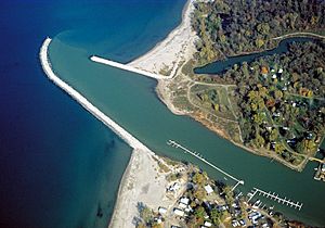
The mouth of the Cattaraugus Creek as seen from overhead. At bottom is the community of Sunset Bay; at top is Snyder Beach on the Cattaraugus Reservation.
|
|
| Country | United States |
| State | New York |
| County | Chautauqua |
| Town | Hanover |
| Area | |
| • Total | 0.71 sq mi (1.83 km2) |
| • Land | 0.66 sq mi (1.72 km2) |
| • Water | 0.04 sq mi (0.11 km2) |
| Elevation | 580 ft (180 m) |
| Population
(2020)
|
|
| • Total | 470 |
| • Density | 708.90/sq mi (273.60/km2) |
| Time zone | UTC-5 (Eastern (EST)) |
| • Summer (DST) | UTC-4 (EDT) |
| Area code(s) | 716 |
| FIPS code | 36-72246 |
| GNIS feature ID | 0966831 |
Sunset Bay is a small community in New York State. It is located in Chautauqua County, within the town of Hanover. In 2020, about 470 people lived there.
Sunset Bay is right next to the Cattaraugus Indian Reservation. For many years, some non-native people lived in vacation homes on the reservation land near Sunset Bay. In 2012, the Seneca Nation decided that these leases were not valid. Because of this, the non-native residents moved out of the area.
Contents
Exploring Sunset Bay's Location
Sunset Bay sits on the edge of Lake Erie. This makes it a great spot for water activities. It is the northernmost point in both the town of Hanover and Chautauqua County.
Nearby Natural Features
To the northeast of Sunset Bay is Cattaraugus Creek. This creek flows into Lake Erie just north of a part of the lake called Sunset Bay.
Roads and Travel
Major roads like U.S. Route 20 and New York State Route 5 run through the community. They are known as Main Road here. You can also easily get to the New York State Thruway (which is Interstate 90) from a short road just east of the community. The city of Dunkirk is about 12 miles (19 km) southwest. Buffalo is about 29 miles (47 km) northeast.
Understanding the Area's Geography
The area around Cattaraugus Creek can sometimes flood. This happens often in the spring, especially when the creek's water levels rise quickly.
According to the United States Census Bureau, Sunset Bay covers a total area of about 0.71 square miles (1.8 square kilometers). Most of this area is land, about 0.66 square miles (1.7 square kilometers). The rest, about 0.04 square miles (0.1 square kilometers), is water.
Population of Sunset Bay
| Historical population | |||
|---|---|---|---|
| Census | Pop. | %± | |
| 2020 | 470 | — | |
| U.S. Decennial Census | |||
The number of people living in Sunset Bay changes over time. In 2020, the population was 470 people.
See also
 In Spanish: Sunset Bay (Nueva York) para niños
 | William M. Jackson |
 | Juan E. Gilbert |
 | Neil deGrasse Tyson |


