Hanover, New York facts for kids
Quick facts for kids
Hanover, New York
|
|
|---|---|

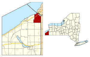
Location within Chautauqua County and New York
|
|
| Country | United States |
| State | New York |
| County | Chautauqua |
| Government | |
| • Type | Town Council |
| Area | |
| • Total | 49.46 sq mi (128.10 km2) |
| • Land | 49.18 sq mi (127.37 km2) |
| • Water | 0.28 sq mi (0.73 km2) |
| Elevation | 951 ft (290 m) |
| Population
(2020)
|
|
| • Total | 6,944 |
| • Estimate
(2021)
|
6,893 |
| • Density | 139.17/sq mi (53.73/km2) |
| Time zone | UTC-5 (Eastern (EST)) |
| • Summer (DST) | UTC-4 (EDT) |
| ZIP code | |
| FIPS code | 36-013-32050 |
| GNIS feature ID | 0979045 |
Hanover is a town in Chautauqua County, New York, United States. It is located in the northeast part of Chautauqua County. In 2020, the town had a population of 6,944 people.
Contents
History of Hanover
The first settler arrived in the area that is now Hanover in 1796. The town of Hanover was officially formed in 1812. It was created from a part of the town of Pomfret. Later, the size of Hanover was made smaller. This happened when new towns like Villenova (in 1823) and Sheridan (in 1827) were formed from its land.
Famous People from Hanover
- Jonathan D. Davis – He was a state senator in Michigan.
- Mary Smith Lockwood – She helped start the Daughters of the American Revolution, a group focused on American history.
Geography of Hanover
Hanover covers a total area of about 128.1 square kilometers (49.5 square miles). Most of this area, about 127.4 square kilometers (49.2 square miles), is land. Only a small part, about 0.7 square kilometers (0.28 square miles), is water.
Major Roads in Hanover
Several important roads pass through the northern part of Hanover. These include the New York State Thruway (Interstate 90), US 20, and NY 5. New York State Route 39 also crosses through the middle of the town.
Neighboring Areas
To the north, Hanover borders Lake Erie. On its northeast side, it meets Cattaraugus Creek. This creek forms the boundary with the Cattaraugus Reservation in Erie County. The eastern border of Hanover is shared with the town of Perrysburg. It also borders a part of the Cattaraugus Reservation in Cattaraugus County. To the south, Hanover shares a border with Villenova and Arkwright. The western border is shared with the town of Sheridan.
Population of Hanover
In 2000, there were 7,638 people living in Hanover. The population density was about 155 people per square mile. There were 2,975 households in the town.
The population was spread out by age. About 25.4% of the people were under 18 years old. About 16.4% were 65 years or older. The average age in the town was 39 years.
Communities and Locations in Hanover
- Balltown – A small community in the southeast part of the town.
- Cattaraugus Reservation – A special area for the Seneca tribe. It borders the northeast part of the town.
- Dennisons Corners – A location north of Keaches Corners.
- Forestville – A community near the western town line, in the southwest part of Hanover. It is on NY-39.
- Hanford Bay – A community by the lake in the northeast part of the town.
- Hanover Center – A community southeast of Silver Creek.
- Irving – A community on NY-5 and US 20 at the northeast town line. It was once called "Cattaraugus."
- Keaches Corners – A community north of Forestville.
- Nashville – A community on Route 39 in the southeast corner of the town. It was named after an early settler, Deacon Silas Nash.
- Parcells Corners – A community in the southeast part of town.
- Silver Creek – A village in the northeast corner of the town. It is on US Route 20 and NY Route 5.
- Smith's Mills – A community in the eastern part of the town. It was named after Rodney Smith, who lived there.
- Sunset Bay – A community by the lake in the northeast part of the town.
Public Safety in Hanover
Law Enforcement
The Chautauqua County Sheriff's Office and the New York State Police help keep the town safe. The town also has two justices, Philip Hall and James McGowan, who handle court cases.
Fire Protection
Several volunteer fire departments protect the town of Hanover:
- Silver Creek Volunteer Fire Department – This department covers areas from the Sheridan/Silver Creek line to parts of Hanover Center and Sunset Bay.
- Irving Volunteer Fire Department – This department covers areas from the county line west to Seneca Road. They also respond to calls on the New York State Thruway.
- Sunset Bay Volunteer Fire Company – This is an independent fire company that covers Sunset Bay and nearby areas.
- Hanover Hose Company #1 (Hanover Center) – This company started in 1959. It covers the largest area for fire protection in the town.
- Forestville Volunteer Fire Department – This department serves the village of Forestville. It also helps with fire and EMS in parts of Hanover, Villenova, and Arkwright.
Emergency Medical Services (EMS)
- Silver Creek EMS – This group provides emergency medical help to residents north of King Road. They also help on the NYS Thruway. More advanced medical care is provided by Alstar Ambulance from Dunkirk.
All these services are called out by the Chautauqua County Sheriff's Dispatch Center in Mayville.
See also
 In Spanish: Hanover (Nueva York) para niños
 | Victor J. Glover |
 | Yvonne Cagle |
 | Jeanette Epps |
 | Bernard A. Harris Jr. |


