Sheridan, New York facts for kids
Quick facts for kids
Sheridan, New York
|
|
|---|---|

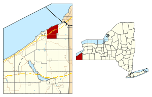
Location within Chautauqua County and New York
|
|
| Country | United States |
| State | New York |
| County | Chautauqua |
| Government | |
| • Type | Town Council |
| Area | |
| • Total | 37.30 sq mi (96.61 km2) |
| • Land | 37.25 sq mi (96.48 km2) |
| • Water | 0.05 sq mi (0.13 km2) |
| Elevation | 761 ft (232 m) |
| Population
(2020)
|
|
| • Total | 2,563 |
| • Estimate
(2021)
|
2,544 |
| • Density | 69.07/sq mi (26.67/km2) |
| Time zone | UTC-5 (Eastern (EST)) |
| • Summer (DST) | UTC-4 (EDT) |
| ZIP code |
14135
|
| Area code(s) | 716 |
| FIPS code | 36-013-66916 |
| GNIS feature ID | 0979491 |
| Website | https://www.sheridanny.org/ |
Sheridan is a small town in Chautauqua County, New York, United States. In 2020, about 2,563 people lived there. The town is located on the northern edge of the county, just east of Dunkirk.
Contents
History
When Sheridan Was Founded
People first started settling in the Sheridan area around 1804. The town of Sheridan was officially created in 1827. It was formed from parts of two other towns: Hanover and Pomfret.
Geography
Sheridan's Location and Size
Sheridan covers a total area of about 96.6 square kilometers (37.3 square miles). Most of this area, about 96.5 square kilometers (37.25 square miles), is land. Only a very small part, about 0.1 square kilometers (0.05 square miles), is water.
The town is located on the southern shore of Lake Erie, one of the Great Lakes.
Roads and Highways
Two important roads pass through Sheridan:
- The New York State Thruway (also known as Interstate 90)
- U.S. Route 20
Nearby Towns and Areas
Sheridan is surrounded by different areas:
- To the north is Lake Erie

- To the east is Hanover

- To the south is Arkwright

- To the west are Pomfret and Dunkirk

Population Information
How Many People Live Here?
| Historical population | |||
|---|---|---|---|
| Census | Pop. | %± | |
| 1830 | 1,666 | — | |
| 1840 | 1,883 | 13.0% | |
| 1850 | 2,173 | 15.4% | |
| 1860 | 1,716 | −21.0% | |
| 1870 | 1,686 | −1.7% | |
| 1880 | 1,551 | −8.0% | |
| 1890 | 1,511 | −2.6% | |
| 1900 | 1,633 | 8.1% | |
| 1910 | 1,888 | 15.6% | |
| 1920 | 1,887 | −0.1% | |
| 1930 | 2,035 | 7.8% | |
| 1940 | 1,826 | −10.3% | |
| 1950 | 2,037 | 11.6% | |
| 1960 | 2,539 | 24.6% | |
| 1970 | 2,527 | −0.5% | |
| 1980 | 2,659 | 5.2% | |
| 1990 | 2,582 | −2.9% | |
| 2000 | 2,838 | 9.9% | |
| 2010 | 2,673 | −5.8% | |
| 2020 | 2,563 | −4.1% | |
| 2021 (est.) | 2,544 | −4.8% | |
| U.S. Decennial Census | |||
According to the census from 2000, there were 2,838 people living in Sheridan. These people lived in 994 households, and 737 of these were families. The population density was about 76 people per square mile.
Most of the people living in Sheridan were White (96.34%). About 2.43% of the population identified as Hispanic or Latino.
In 2000, about 33% of households had children under 18 living with them. The average household had 2.60 people, and the average family had 3.02 people. The median age in the town was 43 years old.
The median income for a household in Sheridan was $40,347. For families, the median income was $46,250.
Education
School Districts in Sheridan
Students in Sheridan attend schools in several different school districts. These include:
- Silver Creek
- Forestville
- Dunkirk City Schools
- Fredonia
Communities and Locations
Places to Know in Sheridan
Sheridan has several smaller communities and important locations:
- Center Corners – This is a small community, called a hamlet, located right on the shore of Lake Erie, along Route 5.
- Chautauqua County/Dunkirk Airport (DKK) – This is an airport mainly used for general aviation. It is located in the western part of the town.
- Cook Corners – Another hamlet, found southwest of the main Sheridan village on Route 20.
- Hawkins Corner – This location is east of the Sheridan village on Route 84.
- Sheridan – This is the main hamlet of Sheridan itself. It is located on Route 20, south of the New York State Thruway.
Local Services
How Sheridan Stays Safe
Sheridan has its own volunteer fire department. This department is run by a board of fire commissioners. While they respond to emergencies, they work with Alstar Ambulance for ambulance transport. If Alstar is busy, other nearby towns like Fredonia, Silver Creek, or Forestville help out.
Law enforcement in Sheridan is handled by the New York State Police and the Chautauqua County Sheriff's Office.
Notable People
Famous Folks from Sheridan
Some well-known people have come from Sheridan:
- John Cranston – A college football player who was recognized as an All-American.
- Daniel A. Reed – A former U.S. congressman and also a football player.
- Cyrus Remington – A politician who served in the Wisconsin State Assembly and was also a judge.
See also
 In Spanish: Sheridan (Nueva York) para niños
 | Roy Wilkins |
 | John Lewis |
 | Linda Carol Brown |


