Arkwright, New York facts for kids
Quick facts for kids
Arkwright, New York
|
|
|---|---|

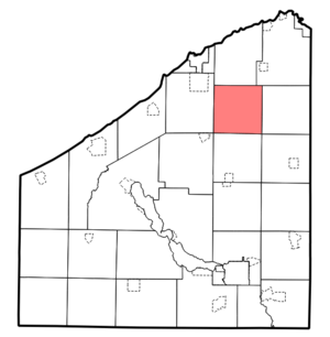
Location within Chautauqua County
|
|
| Country | United States |
| State | New York |
| County | Chautauqua |
| Government | |
| • Type | Town council |
| Area | |
| • Total | 35.74 sq mi (92.56 km2) |
| • Land | 35.68 sq mi (92.40 km2) |
| • Water | .06 sq mi (.16 km2) |
| Elevation | 1,657 ft (505 m) |
| Population
(2020)
|
|
| • Total | 1,000 |
| • Estimate
(2021)
|
999 |
| • Density | 29.04/sq mi (11.21/km2) |
| Time zone | UTC-5 (Eastern (EST)) |
| • Summer (DST) | UTC-4 (EDT) |
| FIPS code | 36-013-02605 |
| GNIS feature ID | 0978689 |
Arkwright is a small town in Chautauqua County, New York, United States. In 2020, about 1,000 people lived there. The town gets its name from Richard Arkwright, who invented a machine for spinning thread.
Arkwright is located in the northeastern part of Chautauqua County. It is southeast of the city of Dunkirk.
Contents
History of Arkwright
People first started settling in the Arkwright area around 1807. The town of Arkwright was officially created in 1829. It was formed from parts of two other towns, Villenova and Pomfret.
In the early days, dairy farms and making cheese were very important for the town's economy. Arkwright was one of the first towns in New York to create a cheese cooperative. This means farmers worked together to make and sell their cheese.
Geography of Arkwright
The town of Arkwright covers about 92.5 square kilometers (about 35.7 square miles). Most of this area is land, with a small amount of water.
New York State Route 83 is a main road that goes through the town from east to west.
Canadaway Creek flows through the southern part of Arkwright. Along this creek, you can find Arkwright Falls, a beautiful waterfall. You can reach the creek from a county park on Ball Road.
Neighboring Towns
Arkwright is surrounded by several other towns:
- To the west is the town of Pomfret.
- To the east is the town of Villenova.
- To the north are the towns of Sheridan and Hanover.
- To the south is the town of Charlotte.
Population Information
| Historical population | |||
|---|---|---|---|
| Census | Pop. | %± | |
| 1830 | 926 | — | |
| 1840 | 1,418 | 53.1% | |
| 1850 | 1,283 | −9.5% | |
| 1860 | 1,103 | −14.0% | |
| 1870 | 1,030 | −6.6% | |
| 1880 | 1,076 | 4.5% | |
| 1890 | 886 | −17.7% | |
| 1900 | 918 | 3.6% | |
| 1910 | 843 | −8.2% | |
| 1920 | 757 | −10.2% | |
| 1930 | 746 | −1.5% | |
| 1940 | 688 | −7.8% | |
| 1950 | 665 | −3.3% | |
| 1960 | 700 | 5.3% | |
| 1970 | 833 | 19.0% | |
| 1980 | 980 | 17.6% | |
| 1990 | 1,040 | 6.1% | |
| 2000 | 1,126 | 8.3% | |
| 2010 | 1,061 | −5.8% | |
| 2020 | 1,000 | −5.7% | |
| 2021 (est.) | 999 | −5.8% | |
| U.S. Decennial Census | |||
In 2000, there were 1,126 people living in Arkwright. The population density was about 31.5 people per square mile. There were 421 households, with many being married couples living together.
The population in 2000 included:
- About 26% of residents were under 18 years old.
- About 31% were between 25 and 44 years old.
- About 9% were 65 years or older.
The average age in the town was 38 years.
Places in Arkwright
Here are some of the communities and interesting spots you can find in Arkwright:
- Arkwright – This is the main hamlet (a small settlement) of the town. It's on the west side, where Route 83 meets County Road 79.
- Black Corners – Another hamlet located on Route 83, east of Arkwright.
- Canadaway State Wildlife Management Area – A special area in the southern part of the town set aside for wildlife and nature.
- Chicken Tavern – A place found on Route 83, between Arkwright and Black Corners.
- Cowdens Corners – A hamlet in the northwest corner of the town, also on Route 83.
- Griswold – A hamlet in the southern part of the town, where County Roads 72 and 79 meet.
- Towns Corners – A location near the eastern border of the town.
- West Mud Lake – A small lake on the eastern town line, close to Route 83.
See also
 In Spanish: Arkwright (Nueva York) para niños
 | John T. Biggers |
 | Thomas Blackshear |
 | Mark Bradford |
 | Beverly Buchanan |


