West Valley, New York facts for kids
Quick facts for kids
West Valley, New York
|
|
|---|---|
| Country | United States |
| State | New York |
| County | Cattaraugus County |
| Town | Ashford |
| Area | |
| • Total | 1.53 sq mi (3.97 km2) |
| • Land | 1.53 sq mi (3.97 km2) |
| • Water | 0.00 sq mi (0.01 km2) |
| Elevation | 1,522 ft (464 m) |
| Population
(2020)
|
|
| • Total | 452 |
| • Density | 295.04/sq mi (113.91/km2) |
| Time zone | UTC-5 (Eastern (EST)) |
| • Summer (DST) | UTC-4 (EDT) |
| ZIP code |
14171
|
| Area code | 716 |
| FIPS code | 36-81138 |
| GNIS feature ID | 970885 |
West Valley is a small community in Cattaraugus County, New York, United States. It is known as a hamlet, which is a small settlement, and also a census-designated place (CDP). A CDP is an area that the government counts for population but doesn't have its own separate local government. In 2020, about 452 people lived there.
Even though West Valley has its own school, a phone number area code (716–942), and a post office, it's not officially a town or village. It is part of the larger Town of Ashford.
Contents
Where is West Valley Located?
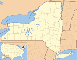
West Valley is found where two roads meet: Cattaraugus County Route 53 and State Route 240/County Route 32. Its exact location is 42°24′10″N 078°36′36″W / 42.40278°N 78.61000°W. The land here is about 1,522 feet (464 meters) above sea level.
Land and Water
According to information from 2010, West Valley covers about 1.53 square miles (3.97 square kilometers). Almost all of this area is land, with only a tiny bit of water.
People Living in West Valley
The number of people living in West Valley changes over time. Here's how the population has been counted:
| Historical population | |||
|---|---|---|---|
| Census | Pop. | %± | |
| 2020 | 452 | — | |
| U.S. Decennial Census | |||
What Makes West Valley Special?
West Valley is home to the West Valley Central School, which serves students in the area. It also has an important facility called the West Valley Demonstration Project. This project works to clean up and safely manage waste from an old nuclear fuel reprocessing plant. It's a big effort to protect the environment.
See also
 In Spanish: West Valley (Nueva York) para niños
 | Aurelia Browder |
 | Nannie Helen Burroughs |
 | Michelle Alexander |


