Ellery, New York facts for kids
Quick facts for kids
Ellery, New York
|
|
|---|---|

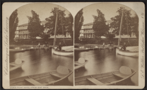
Bemus Point Hotel and Boat Dock, Bemus Point, NY
|
|

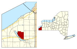
Location within Chautauqua County and New York
|
|
| Country | United States |
| State | New York |
| County | Chautauqua |
| Government | |
| • Type | Town Council |
| Area | |
| • Total | 47.57 sq mi (123.21 km2) |
| • Land | 47.45 sq mi (122.90 km2) |
| • Water | 0.12 sq mi (0.30 km2) |
| Elevation | 1,594 ft (486 m) |
| Population
(2020)
|
|
| • Total | 4,105 |
| • Estimate
(2021)
|
4,080 |
| • Density | 92.72/sq mi (35.80/km2) |
| Time zone | UTC-5 (Eastern (EST)) |
| • Summer (DST) | UTC-4 (EDT) |
| Area code(s) | 716 |
| FIPS code | 36-013-23976 |
| GNIS feature ID | 0978932 |
Ellery is a lovely town in Chautauqua County, New York, United States. It's located northwest of Jamestown. A big part of Ellery is right along the eastern side of Chautauqua Lake. In 2020, about 4,105 people lived in Ellery.
Contents
History of Ellery
Who Lived Here First?
The land where Ellery is now was first home to the Erie People. They lived here long before European settlers arrived.
When Was Ellery Founded?
The first European settlers came to this area around 1806. The town of Ellery was officially created in 1821. It was formed from a part of the nearby town of Chautauqua.
Who Is Ellery Named After?
Ellery is named after William Ellery. He was a very important person who signed the Declaration of Independence. This document declared America's freedom from Great Britain.
Ellery as a Tourist Spot
Early on, the beautiful lakefront areas of Ellery became popular. People started visiting for fun and relaxation. It quickly grew into a well-known tourist and recreational spot.
Geography of Ellery
How Big Is Ellery?
Ellery covers a total area of about 123.2 square kilometers (47.57 square miles). Most of this area, about 122.9 square kilometers (47.45 square miles), is land. Only a small part, about 0.3 square kilometers (0.12 square miles), is water.
Major Roads in Ellery
Several important roads run through Ellery:
- The Southern Tier Expressway, which includes Interstate 86 and New York State Route 17, crosses Chautauqua Lake near Bemus Point.
- New York State Route 430 follows the eastern shore of Chautauqua Lake.
- New York State Route 380 is a north-south road in the eastern part of Ellery.
Neighboring Towns and Areas
Ellery shares its borders with several other towns:
- To the north, it mostly borders the town of Stockton.
- A small part of its northwest corner touches the town of Chautauqua.
- To the east, Ellery is next to the towns of Gerry and Ellicott.
- Its southern and western edges are mostly along Chautauqua Lake.
Population of Ellery
| Historical population | |||
|---|---|---|---|
| Census | Pop. | %± | |
| 1830 | 2,001 | — | |
| 1840 | 2,242 | 12.0% | |
| 1850 | 2,104 | −6.2% | |
| 1860 | 1,751 | −16.8% | |
| 1870 | 1,616 | −7.7% | |
| 1880 | 1,555 | −3.8% | |
| 1890 | 1,789 | 15.0% | |
| 1900 | 1,628 | −9.0% | |
| 1910 | 1,695 | 4.1% | |
| 1920 | 1,496 | −11.7% | |
| 1930 | 1,919 | 28.3% | |
| 1940 | 2,088 | 8.8% | |
| 1950 | 2,852 | 36.6% | |
| 1960 | 3,953 | 38.6% | |
| 1970 | 4,594 | 16.2% | |
| 1980 | 4,617 | 0.5% | |
| 1990 | 4,534 | −1.8% | |
| 2000 | 4,574 | 0.9% | |
| 2010 | 4,528 | −1.0% | |
| 2020 | 4,105 | −9.3% | |
| 2021 (est.) | 4,080 | −9.9% | |
| U.S. Decennial Census | |||
How Many People Live in Ellery?
The population of Ellery has changed over the years. In the year 2000, there were 4,576 people living in the town. By 2010, the population had slightly decreased to 4,528 people. The most recent count in 2020 showed a population of 4,105 people.
Homes in Ellery
In 2000, there were 1,852 households in Ellery. A household means all the people living together in one home. Many of these households were families. By 2010, the number of households increased slightly to 1,891.
Communities and Locations in Ellery
Ellery is home to many interesting communities and places:
- Alden Corners – A spot north of Ellery Center.
- Bayview – A small community by the lake, north of Bemus Point.
- Belleview – A lakeside community on Route 430 in the southern part of town.
- Bemus Bay – A bay on Chautauqua Lake between Long Point State Park and Bemus Point.
- Bemus Point – A village named after a piece of land sticking into Chautauqua Lake.
- Chedwel – A community along the northern shore of the town.
- Colburns – A community on the lake shore and on Route 430, south of Bemus Point.
- Crosswinds – A marina community on Route 430 in the northwest corner.
- Driftwood – A lakeside community south of Colburns.
- Dutch Hollow Creek – A stream flowing south from Ellery Center into Chautauqua Lake.
- Ellery Center – A central community where several county roads meet.
- Greenhurst – A lakeside community in the southern part of town.
- Griffiths – Another lakeside community in the southern part of town.
- Jones Corners – A community at the intersection of County Roads 52 and 57.
- Long Point State Park – A state park on Route 430, located on the east shore of the lake.
- Maple Springs – A lakeside community north of Long Point State Park.
- Midway Park – A place on the lake shore north of Long Point State Park.
- Oriental Park – A community next to Bemus Point on its south side.
- Phillips Mill – A community on the shore of Chautauqua Lake.
- Point Stockholm – A lakeside community.
- Red Bird – A community on County Route 380 in the northeast corner of town.
- Sheldon Hall – A lakeside community in the southern part of town.
- Sunnyside – A lakeside community in the southern part of town.
- Sunset Bay – A community of homes and cottages by a bay of the same name on Chautauqua Lake.
- Towerville – A community where County Road 48 and Route 380 meet in the northeast corner.
- Watermans Corners – A community in the northern part of town where several roads meet.
- West Ellery – A community in the northern part of town on County Road 46.
- Willow Brook – A location north of Bemus Point.
- Warner Bay - A community of homes and cottages along a bay on Chautauqua Lake.
See also
 In Spanish: Ellery (Nueva York) para niños
 | Misty Copeland |
 | Raven Wilkinson |
 | Debra Austin |
 | Aesha Ash |


