Gerry, New York facts for kids
Quick facts for kids
Gerry, New York
|
|
|---|---|

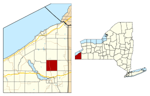
Location within Chautauqua County and New York
|
|
| Country | United States |
| State | New York |
| County | Chautauqua |
| Government | |
| • Type | Town Council |
| Area | |
| • Total | 36.14 sq mi (93.61 km2) |
| • Land | 36.13 sq mi (93.56 km2) |
| • Water | 0.02 sq mi (0.05 km2) |
| Elevation | 1,683 ft (513 m) |
| Population
(2020)
|
|
| • Total | 1,789 |
| • Estimate
(2021)
|
1,775 |
| • Density | 51.35/sq mi (19.83/km2) |
| Time zone | UTC-5 (Eastern (EST)) |
| • Summer (DST) | UTC-4 (EDT) |
| ZIP code |
14740
|
| Area code(s) | 716 |
| FIPS code | 36-013-28838 |
| GNIS feature ID | 0978999 |
Gerry is a small town located in Chautauqua County, New York. In 2020, about 1,789 people lived here. The town is named after Elbridge Gerry, who was the fifth Vice President of the United States. Gerry is in the center of Chautauqua County, just north of the city of Jamestown.
Contents
History of Gerry
Settlers first arrived in the area around 1810. One of the first was Amos Atkins, a surveyor, who built a log cabin. The town of Gerry was officially created on June 1, 1812. It was formed from a part of the older town of Pomfret.
The first town meeting was held at the home of Major Samuel Sinclair. He was chosen as the first Supervisor that same year. The nearby community of Sinclairville is named after him. Over time, the towns of Ellington and Charlotte were formed, which made Gerry a bit smaller. By 1900, Gerry had a population of 1,198 people.
Today, Gerry is well-known for two fun summer events. It hosts an annual rodeo, which has been a tradition since 1945. The town also holds a Scandinavian folk festival, celebrating Scandinavian culture.
Geography of Gerry
The town of Gerry covers a total area of about 93.6 square kilometers (36.14 square miles). Most of this area is land, with only a tiny part (0.05 square kilometers or 0.02 square miles) being water.
New York State Route 60 is an important highway that runs north and south through the town. Another road, Chautauqua County Route 380, goes through the southwest part of Gerry.
Neighboring Towns
Gerry shares its borders with several other towns. Here they are, listed clockwise:
Population and People
| Historical population | |||
|---|---|---|---|
| Census | Pop. | %± | |
| 1820 | 947 | — | |
| 1830 | 1,110 | 17.2% | |
| 1840 | 1,288 | 16.0% | |
| 1850 | 1,332 | 3.4% | |
| 1860 | 1,315 | −1.3% | |
| 1870 | 1,096 | −16.7% | |
| 1880 | 1,175 | 7.2% | |
| 1890 | 1,088 | −7.4% | |
| 1900 | 1,198 | 10.1% | |
| 1910 | 1,155 | −3.6% | |
| 1920 | 993 | −14.0% | |
| 1930 | 1,112 | 12.0% | |
| 1940 | 1,073 | −3.5% | |
| 1950 | 1,347 | 25.5% | |
| 1960 | 1,468 | 9.0% | |
| 1970 | 1,636 | 11.4% | |
| 1980 | 2,022 | 23.6% | |
| 1990 | 2,147 | 6.2% | |
| 2000 | 2,054 | −4.3% | |
| 2010 | 1,905 | −7.3% | |
| 2020 | 1,789 | −6.1% | |
| 2021 (est.) | 1,775 | −6.8% | |
| U.S. Decennial Census | |||
In 2000, the town of Gerry had 2,054 people living in it. There were 661 households, and 499 of these were families. About 34% of households had children under 18 living with them. The average household had about 2.66 people.
The population was spread out in terms of age. About 23% were under 18 years old. Around 25% were between 25 and 44 years old. About 25% were 65 years or older. The average age in Gerry was 42 years.
By the 2010 Census, the population had slightly decreased to 1,905 people. There were 722 households. Most of the people living in Gerry were white (about 97.9%). About 19.7% of the population was under 18 years old.
Communities and Locations in Gerry
- Cassadaga Creek – This is a stream that flows south through the western part of the town. It eventually joins the Conewango Creek, which is part of the larger Allegheny River system.
- Gerry – This is the main hamlet (a small community) in the town. It is located where County Roads 50 and 65 meet New York State Route 60. It was first known as Bucklins Corners and later as "Vermont" before being named Gerry in 1876.
- Hatch Creek – Another stream that flows into Cassadaga Creek in the southwest part of the town.
- Kimball Stand – A hamlet found in the southwest corner of Gerry. It is located along NY Routes 60 and 380, and County Road 44.
- Sinclairville – A part of this village is located near the northern border of the town of Gerry.
- Towerville – This hamlet is on the western edge of the town, along NY Route 380 and County Road 48.
Notable People from Gerry
- Hugh Bedient – A former professional baseball player.
- John Schofield – A significant figure in the US Civil War and a former Secretary of War.
See also
 In Spanish: Gerry (Nueva York) para niños
 | Calvin Brent |
 | Walter T. Bailey |
 | Martha Cassell Thompson |
 | Alberta Jeannette Cassell |


