Chautauqua Lake facts for kids
Quick facts for kids Chautauqua Lake |
|
|---|---|

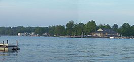
View from Stow, New York, towards Bemus Point
|
|
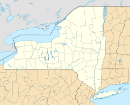
| Location | Chautauqua County, New York |
| Coordinates | 42°09′22″N 79°23′44″W / 42.15611°N 79.39556°W |
| Lake type | Natural |
| Primary inflows | Big Inlet |
| Primary outflows | Chadakoin River |
| Catchment area | 180 sq mi (470 km2) |
| Basin countries | United States |
| Max. length | 17 mi (27 km) |
| Max. width | 2 mi (3.2 km) |
| Surface area | 13,000 acres (5,300 ha) |
| Max. depth | 78 ft (24 m) |
| Shore length1 | 41 mi (66 km) |
| Surface elevation | 1,308 ft (399 m) |
| Settlements | Jamestown |
| 1 Shore length is not a well-defined measure. | |
Chautauqua Lake is a beautiful lake located entirely within Chautauqua County, New York, in the state of New York, United States. It is about 17 miles (27 km) long and 2 miles (3.2 km) wide at its widest point. The lake covers an area of about 13,000 acres (53 km²). Its deepest spot is around 78 feet (24 m). Most of its 41-mile (66 km) shoreline is privately owned.
The lake's name comes from an old Native American language, the now-extinct Erie language. Its exact meaning is a bit of a mystery! Some people think it means "bag tied in the middle" or "place where fish are taken out."
Contents
Exploring Chautauqua Lake's Geography
Chautauqua Lake is quite unique! Even though it's long and narrow like the famous Finger Lakes in New York, it's not actually one of them. Chautauqua Lake runs in a different direction and was likely formed in a different way.
Lake Elevation and Water Flow
Chautauqua Lake sits high up, about 1,308 feet (399 m) above sea level. This makes it one of the highest lakes in North America where boats can travel.
The water from the lake flows south. It first empties into the Chadakoin River in Jamestown, New York. From there, it travels into other creeks and rivers, eventually reaching the Allegheny River in Pennsylvania. Finally, it joins the Ohio River in Pittsburgh. This is different from many New York lakes, which often drain north towards the Great Lakes.
Towns and Communities Around the Lake
Many towns and villages are located along the shores of Chautauqua Lake. The City of Jamestown is at the southern end of the lake. The Village of Mayville is at the northern end.
Other communities include Bemus Point, Maple Springs, and Lakewood. The town of Chautauqua is home to the famous Chautauqua Institution. This important center for learning and arts was founded in 1874.
Fun Activities and Tourism at Chautauqua Lake


Chautauqua Lake is a popular spot for fun and relaxation. People love to come here for boating, fishing, and enjoying the beautiful scenery.
Popular Attractions and Events
Many tourists visit the Chautauqua Institution. It has many shops, restaurants, and hosts live music and public talks during the summer. The lake is also famous for muskellunge fishing and sailing.
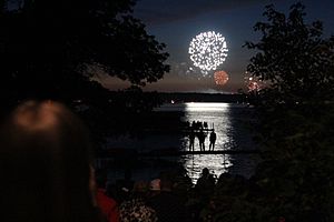
Two popular spots for boating are "Sandy Bottoms" and Long Point State Park. On warm weekends, you can see many boats gathered in these areas. Every Fourth of July, communities around the lake put on amazing fireworks shows.
Crossing the Lake: Bridge and Ferry
There is one main bridge that connects the opposite sides of the lake. It's called the Veterans Memorial Bridge, also known as the Chautauqua Lake Bridge. This bridge was finished in 1982. It connects Bemus Point to Stow on I-86.
Before the bridge was built, cars could only cross the lake using the Bemus Point–Stow ferry. This ferry is a cable-guided boat that can carry nine cars. It still operates during the summer months and is now a fun tourist attraction. The ferry ride is free, but donations are welcome.
Boating and Dining Experiences
The lake is home to the Chautauqua Belle. This is a replica of an old sternwheeler steamboat built in 1975. It offers fun sightseeing cruises on the lake.
The Summer Wind is another popular boat that offers lake tours and dinner cruises. It departs from Celoron, at the southern end of the lake.
The Village Casino in Bemus Point is a popular restaurant and bar. Boaters can tie up at the Casino's dock and even get service right there! This place has a lot of history and offers nightlife on the lake. Don't let the name fool you, though – it doesn't offer gambling.
Yacht Clubs
There are two yacht clubs located on the lake. These are the Chautauqua Lake Yacht Club in Lakewood and the Chautauqua Yacht Club in Chautauqua.
See also
 In Spanish: Lago Chautauqua para niños
 | Sharif Bey |
 | Hale Woodruff |
 | Richmond Barthé |
 | Purvis Young |


