Mina, New York facts for kids
Quick facts for kids
Mina, New York
|
|
|---|---|

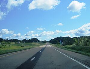
Scenery in Mina along eastbound Interstate 86
|
|
| Motto(s):
"The western gateway to New York State"
|
|

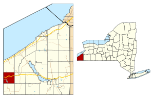
Location within Chautauqua County and New York
|
|
| Country | United States |
| State | New York |
| County | Chautauqua |
| Government | |
| • Type | Town Council |
| Area | |
| • Total | 36.33 sq mi (94.09 km2) |
| • Land | 35.82 sq mi (92.77 km2) |
| • Water | 0.51 sq mi (1.32 km2) |
| Elevation | 1,634 ft (498 m) |
| Population
(2020)
|
|
| • Total | 1,004 |
| • Estimate
(2021)
|
994 |
| • Density | 29.93/sq mi (11.56/km2) |
| Time zone | UTC-5 (Eastern (EST)) |
| • Summer (DST) | UTC-4 (EDT) |
| ZIP code |
14736 (Findley Lake)
|
| FIPS code | 36-013-47592 |
| GNIS feature ID | 0979222 |
Mina is a small town located in Chautauqua County, New York, in the United States. In 2020, about 1,004 people lived there. The town is found right on the western edge of the county and the state border. Mina is well-known as a popular place for summer vacations, especially around the area of Findley Lake.
Contents
History of Mina
The area where Mina is now located was first settled around the year 1815. A person named Alexander Findley was one of the first settlers. He built the very first mills in the area.
How Mina Became a Town
The town of Mina was officially created in 1824. It was formed from a part of another town called Clymer. Later, in 1832, a section of Mina was used to create yet another new town, which was named Sherman. By 1915, the population of Mina was 1,021 people.
Geography of Mina
Mina covers a total area of about 94.1 square kilometers (36.3 square miles). Most of this area, about 92.8 square kilometers (35.8 square miles), is land. The rest, about 1.3 square kilometers (0.5 square miles), is water. This means about 1.41% of the town's total area is water.
Roads and Highways
Interstate 86, a major highway, runs through the northern part of Mina. You can get onto this highway from exit 4. Two important state roads, New York State Route 426 and New York State Route 430, meet each other in the area of Findley Lake.
Neighboring Areas
Mina shares its western border with two townships in Erie County, Pennsylvania. These are North East and Greenfield. To the north of Mina is the town of Ripley. The town of French Creek is located to the south. To the east, Mina is next to the town of Sherman.
Population of Mina
| Historical population | |||
|---|---|---|---|
| Census | Pop. | %± | |
| 1830 | 1,388 | — | |
| 1840 | 871 | −37.2% | |
| 1850 | 996 | 14.4% | |
| 1860 | 1,200 | 20.5% | |
| 1870 | 1,092 | −9.0% | |
| 1880 | 1,102 | 0.9% | |
| 1890 | 1,125 | 2.1% | |
| 1900 | 1,038 | −7.7% | |
| 1910 | 1,033 | −0.5% | |
| 1920 | 903 | −12.6% | |
| 1930 | 944 | 4.5% | |
| 1940 | 818 | −13.3% | |
| 1950 | 1,012 | 23.7% | |
| 1960 | 1,188 | 17.4% | |
| 1970 | 1,129 | −5.0% | |
| 1980 | 1,245 | 10.3% | |
| 1990 | 1,129 | −9.3% | |
| 2000 | 1,176 | 4.2% | |
| 2010 | 1,106 | −6.0% | |
| 2020 | 1,004 | −9.2% | |
| 2021 (est.) | 994 | −10.1% | |
| U.S. Decennial Census | |||
In 2000, there were 1,176 people living in Mina. These people lived in 456 households, and 336 of these were families. The population density was about 32.8 people per square mile.
The average household in Mina had about 2.58 people. The average family had about 2.99 people. The median age of people in the town was 40 years old.
Famous People from Mina
Mina and the Findley Lake area have been home to several notable individuals:
- Julian Buesink – He was a car owner and crew chief for Bill Rexford. Rexford won the 1950 NASCAR Grand National Series championship. Julian Buesink lived in Findley Lake.
- Alva J. Brasted – He was born in Findley Lake. He became the 4th Chief of Chaplains of the United States Army.
- Jehuu Caulcrick – An NFL fullback who grew up in Findley Lake.
- Lloyd Moore – A driver in the NASCAR Grand National Series.
- Ebenezer Skellie – He received the Medal of Honor, a very brave award.
- Amos Madden Thayer – A federal judge.
Communities and Locations in Mina
Mina has several smaller communities and important locations:
- Findley Lake – This is a beautiful lake located in the southwestern part of the town. The water from this lake flows north into a branch of French Creek, which is part of the Allegheny River system.
- Findley Lake – This is a small community, or hamlet, named after the lake. Many people have summer homes here. This hamlet is at the northern end of the lake, where NY-426 and NY-430 roads meet.
- Marks Corners – This is a specific location found in the southeastern corner of the town.
- Mina – This is the main hamlet of Mina itself. It is located on NY Route 430 in the eastern part of the town.
See also
 In Spanish: Mina (Nueva York) para niños
 | Bessie Coleman |
 | Spann Watson |
 | Jill E. Brown |
 | Sherman W. White |


