Clymer, New York facts for kids
Quick facts for kids
Clymer, New York
|
|
|---|---|

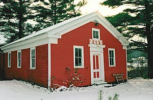
Little Red Schoolhouse in 1997
|
|

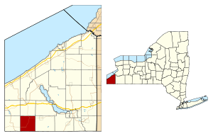
Location within Chautauqua County and New York
|
|
| Country | United States |
| State | New York |
| County | Chautauqua |
| Government | |
| • Type | Town council |
| Area | |
| • Total | 36.16 sq mi (93.66 km2) |
| • Land | 36.07 sq mi (93.42 km2) |
| • Water | .09 sq mi (.24 km2) |
| Elevation | 1,480 ft (451 m) |
| Population
(2020)
|
|
| • Total | 1,748 |
| • Estimate
(2021)
|
1,756 |
| • Density | 45.91/sq mi (17.73/km2) |
| Time zone | UTC-5 (Eastern (EST)) |
| • Summer (DST) | UTC-4 (EDT) |
| ZIP code |
14724
|
| Area code(s) | 716 |
| FIPS code | 36-013-16595 |
| GNIS feature ID | 0978842 |
Clymer is a small town in Chautauqua County, New York. In 2020, about 1,748 people lived there. The town gets its name from George Clymer, who was one of the people who signed the Declaration of Independence. You can find Clymer in the southwest part of Chautauqua County.
Contents
History of Clymer
People started settling in Clymer around 1820. The town of Clymer was officially created in 1821. It was formed from a part of the larger town of Chautauqua.
Later, in 1824, a piece of Clymer became the new town of Mina. Then, in 1829, another part became the town of French Creek. By 1915, about 1,341 people lived in Clymer.
Neckers Co., a general store, has been a part of Clymer since 1910. It's been run by the Neckers family for four generations! The old Clymer District School No. 5 is a special building. It was added to the National Register of Historic Places in 1994, which means it's an important historical site.
Clymer is known for its Dutch heritage. You can see this in the artificial windmills and other decorations around town.
Geography of Clymer
Clymer covers a total area of about 36.16 square miles (93.7 square kilometers). Most of this area is land, with only a small part being water.
New York State Route 474 goes through the town. It meets New York State Route 76 in a part of town called North Clymer.
Neighboring Areas
Clymer shares its southern border with Wayne Township and Columbus Township in Pennsylvania. To the west, you'll find the town of French Creek. The town of Harmony is to the east. North of Clymer is the town of Sherman.
Population and People
| Historical population | |||
|---|---|---|---|
| Census | Pop. | %± | |
| 1830 | 567 | — | |
| 1840 | 909 | 60.3% | |
| 1850 | 1,127 | 24.0% | |
| 1860 | 1,330 | 18.0% | |
| 1870 | 1,486 | 11.7% | |
| 1880 | 1,455 | −2.1% | |
| 1890 | 1,363 | −6.3% | |
| 1900 | 1,229 | −9.8% | |
| 1910 | 1,164 | −5.3% | |
| 1920 | 1,205 | 3.5% | |
| 1930 | 1,181 | −2.0% | |
| 1940 | 1,244 | 5.3% | |
| 1950 | 1,421 | 14.2% | |
| 1960 | 1,377 | −3.1% | |
| 1970 | 1,352 | −1.8% | |
| 1980 | 1,484 | 9.8% | |
| 1990 | 1,474 | −0.7% | |
| 2000 | 1,501 | 1.8% | |
| 2010 | 1,698 | 13.1% | |
| 2020 | 1,748 | 2.9% | |
| 2021 (est.) | 1,756 | 3.4% | |
| U.S. Decennial Census | |||
In 2000, there were 1,501 people living in Clymer. These people made up 502 households and 400 families. The town had about 41.6 people per square mile.
Many households (39.6%) had children under 18 living with them. Most families (72.3%) were married couples living together. About 17.5% of all households were people living alone.
The average age of people in Clymer was 33 years old. About 32.3% of the population was under 18.
Famous People from Clymer
- Charles F. Amidon – A federal judge.
- Loren B. Sessions – A former US congressman.
- Jehuu Caulcrick – A former football player for Michigan State and the NFL. He went to Clymer Central School.
Communities and Places in Clymer
- Clymer – This is the main village in the southwest part of the town. It's where State Route 474 and County Road 15 meet.
- Clymer Center – A small community in the middle of the town. It's near the Little Red Schoolhouse.
- Clymer Hill – You can find this community in the northwest part of the town. It's west of Clymer Center.
- Jaquins – A small community located east of Clymer.
- Kings Corners – This spot is where County Roads 10 and 23 meet, right on the eastern edge of the town.
- North Clymer – A community located where NY Route 474 and State Route 76 meet, near the northern town line.
- Wickwire Corners – This is a location where Wickwire Road and State Route 474 cross. It's east of North Clymer.
Images for kids
See also
 In Spanish: Clymer (Nueva York) para niños
 | James B. Knighten |
 | Azellia White |
 | Willa Brown |


