Kiantone, New York facts for kids
Quick facts for kids
Kiantone, New York
|
|
|---|---|

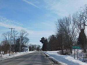
County Route 49 southbound entering the hamlet of Kiantone.
|
|

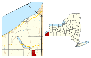
Location within Chautauqua County and New York
|
|
| Country | United States |
| State | New York |
| County | Chautauqua |
| Government | |
| • Type | Town Council |
| Area | |
| • Total | 18.54 sq mi (48.01 km2) |
| • Land | 18.40 sq mi (47.65 km2) |
| • Water | 0.14 sq mi (0.36 km2) |
| Elevation | 1,480 ft (451 m) |
| Population
(2020)
|
|
| • Total | 1,388 |
| • Estimate
(2021)
|
1,376 |
| • Density | 71.70/sq mi (27.68/km2) |
| Time zone | UTC-5 (Eastern (EST)) |
| • Summer (DST) | UTC-4 (EDT) |
| FIPS code | 36-013-39507 |
| GNIS feature ID | 0979115 |
Kiantone (pronounced KIN-tone) is a small town located in Chautauqua County, New York, United States. It's a quiet place with a friendly community.
In 2020, about 1,388 people lived in Kiantone. The town is just south of the city of Jamestown. It also sits right on the southern border of Chautauqua County and the state of New York.
Contents
History of Kiantone
People first started settling in the Kiantone area around the year 1807. This was a time when many new communities were forming in New York.
The town of Kiantone was officially created in 1853. It was formed from a part of the nearby town of Carroll.
Geography and Location
Kiantone covers a total area of about 48 square kilometers (18.5 square miles). Most of this area is land, about 47.6 square kilometers (18.4 square miles). A small part, about 0.4 square kilometers (0.14 square miles), is water.
Major Roads in Kiantone
Several important roads pass through the town. These include U.S. Route 62, New York State Route 60, and County Route 380. These roads help people travel in and out of Kiantone.
Rivers and Waterways
The Conewango Creek flows along most of the eastern border of Kiantone. This creek is a tributary (a smaller stream that flows into a larger river) of the Allegheny River. It flows south from Kiantone into the state of Pennsylvania.
Neighboring Towns and Areas
Kiantone shares its borders with several other towns and townships:
- To the south, it borders Pine Grove and Farmington. Both of these are in Warren County, Pennsylvania.
- To the east, you'll find the town of Carroll.
- To the west is the town of Busti.
- To the north, Kiantone is next to the city of Jamestown and the town of Ellicott.
Population and People
| Historical population | |||
|---|---|---|---|
| Census | Pop. | %± | |
| 1860 | 552 | — | |
| 1870 | 539 | −2.4% | |
| 1880 | 513 | −4.8% | |
| 1890 | 496 | −3.3% | |
| 1900 | 491 | −1.0% | |
| 1910 | 520 | 5.9% | |
| 1920 | 623 | 19.8% | |
| 1930 | 706 | 13.3% | |
| 1940 | 849 | 20.3% | |
| 1950 | 976 | 15.0% | |
| 1960 | 1,254 | 28.5% | |
| 1970 | 1,340 | 6.9% | |
| 1980 | 1,443 | 7.7% | |
| 1990 | 1,322 | −8.4% | |
| 2000 | 1,387 | 4.9% | |
| 2010 | 1,350 | −2.7% | |
| 2020 | 1,388 | 2.8% | |
| 2021 (est.) | 1,376 | 1.9% | |
| U.S. Decennial Census | |||
The population of Kiantone has changed over the years. The table shows how many people have lived in the town since 1860. In 2020, the population was 1,388 people.
In 2000, there were 1,385 people living in Kiantone. Most people lived in families, with many being married couples. About 32.7% of households had children under 18 living there. The average household had about 2.62 people.
The median age in Kiantone in 2000 was 43 years old. This means half the people were younger than 43, and half were older. About 24.3% of the population was under 18 years old.
Notable People from Kiantone
- Elmer Ellsworth Brown – He was an important educator. He even became the chancellor of New York University.
Communities and Places in Kiantone
- Conewango Creek – This is a stream that forms part of the eastern border of the town.
- Kiantone – This is the main hamlet (a small village) in the town. It's located where County Roads 26 and 49 meet in the southern part of the town.
- Stillwater – Another hamlet found in the northwest corner of the town. It's located along NY Route 60 and County Route 380.
See also
 In Spanish: Kiantone (Nueva York) para niños
 | Kyle Baker |
 | Joseph Yoakum |
 | Laura Wheeler Waring |
 | Henry Ossawa Tanner |


