Forest County, Pennsylvania facts for kids
Quick facts for kids
Forest County
|
||
|---|---|---|

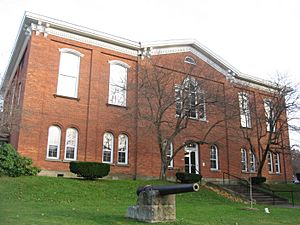
Forest County Courthouse in Tionesta
|
||
|
||

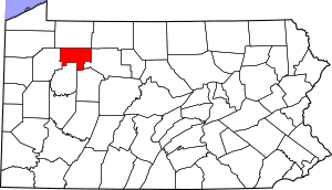
Location within the U.S. state of Pennsylvania
|
||
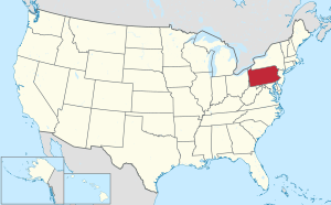
 Pennsylvania's location within the U.S. |
||
| Country | ||
| State | ||
| Founded | September 1, 1857 | |
| Seat | Tionesta | |
| Largest community | Marienville | |
| Area | ||
| • Total | 430 sq mi (1,100 km2) | |
| • Land | 427 sq mi (1,110 km2) | |
| • Water | 3.3 sq mi (9 km2) 0.8%% | |
| Population
(2020)
|
||
| • Total | 6,973 | |
| • Density | 16/sq mi (6/km2) | |
| Time zone | UTC−5 (Eastern) | |
| • Summer (DST) | UTC−4 (EDT) | |
| Congressional district | 15th | |
Forest County is a special area in Pennsylvania. It's called a county. In 2020, about 6,973 people lived there. This makes it one of the least populated counties in Pennsylvania.
The main town, or "county seat," is Tionesta. Forest County was created in 1848 and officially started working as a county in 1857. It is located in the north-central part of Pennsylvania.
Contents
What is the History of Forest County?
Forest County was formed on April 11, 1848. It was made from a part of Jefferson County. Later, on October 31, 1866, it got bigger. A piece of Venango County was added. It's called 'Forest County' because of all the beautiful forests there!
Where is Forest County Located?
Forest County covers about 430 square miles. Most of this (427 square miles) is land. A small part (3.3 square miles) is water. The weather here has warm summers. In Tionesta, the average temperature is about 25 degrees Fahrenheit in January. It rises to about 70 degrees Fahrenheit in July.
What Counties are Next to Forest County?
Forest County shares borders with these other counties:
- Warren County (north)
- McKean County (northeast)
- Elk County (east)
- Jefferson County (south)
- Clarion County (south)
- Venango County (west)
What Protected Areas are in Forest County?
A part of the large Allegheny National Forest is in Forest County. Also, a section of the Allegheny Islands Wilderness is found here.
There are also state-protected areas:
- Part of Cook Forest State Park is in Forest County.
- Part of Cornplanter State Forest is in Forest County.
What are the Main Roads in Forest County?
Here are some of the major highways that go through Forest County:
 US 62
US 62 PA 36
PA 36 PA 66
PA 66 PA 127
 PA 227
 PA 666
 PA 899
 PA 948
Who Lives in Forest County?
| Historical population | |||
|---|---|---|---|
| Census | Pop. | %± | |
| 1860 | 898 | — | |
| 1870 | 4,010 | 346.5% | |
| 1880 | 4,385 | 9.4% | |
| 1890 | 8,482 | 93.4% | |
| 1900 | 11,039 | 30.1% | |
| 1910 | 9,435 | −14.5% | |
| 1920 | 7,477 | −20.8% | |
| 1930 | 5,180 | −30.7% | |
| 1940 | 5,791 | 11.8% | |
| 1950 | 4,944 | −14.6% | |
| 1960 | 4,485 | −9.3% | |
| 1970 | 4,926 | 9.8% | |
| 1980 | 5,072 | 3.0% | |
| 1990 | 4,802 | −5.3% | |
| 2000 | 4,946 | 3.0% | |
| 2010 | 7,716 | 56.0% | |
| 2020 | 6,973 | −9.6% | |
| U.S. Decennial Census 1790-1960 1900-1990 1990-2000 2010-2017 |
|||
In 2000, there were 4,946 people living in Forest County. There were 2,000 households, which are groups of people living together. About 1,328 of these were families. The county had about 12 people per square mile.
Most people in the county were White (77.4%). About 21.1% were Black or African American. Smaller numbers were Native American (0.40%) or Asian (0.14%). About 1.21% of the people were Hispanic or Latino. Many people had German (19.9%), Irish (9.0%), or English (6.2%) backgrounds.
About 23.2% of households had children under 18. More than half (55.7%) were married couples. The average household had 2.29 people. The average family had 2.81 people.
The population was spread out by age. About 22.7% were under 18. About 19.9% were 65 or older. The average age was 44 years. For every 100 females, there were about 111 males.
What was the Population in 2020?
In 2020, the population was 6,973 people. Here's a look at the different groups:
| Race | Number | Percentage |
|---|---|---|
| White | 5,278 | 75.7% |
| Black or African American | 1,235 | 17.71% |
| Native American | 8 | 0.11% |
| Asian | 17 | 0.24% |
| Pacific Islander | 0 | 0% |
| Other/Mixed | 112 | 1.6% |
| Hispanic or Latino | 323 | 4.63% |
What Schools are in Forest County?
The Forest Area School District serves all of Forest County.
There are also private schools:
- Cornell Abraxas I Arlene Lissner (for grades 9-12) in Marienville.
Libraries in the county include:
- Marienville Area Library in Marienville
- Sarah Stewart Bovard Memorial Library in Tionesta
What Communities are in Forest County?
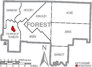
In Pennsylvania, there are different types of towns. These include cities, boroughs, and townships. Here are the boroughs and townships in Forest County:
Borough
- Tionesta (This is the county seat, the main town)
Townships
- Barnett
- Green
- Harmony
- Hickory
- Howe
- Jenks
- Kingsley
- Tionesta
Census-Designated Place
Unincorporated Communities
These are smaller places that are not officially organized as boroughs or townships:
- Brookston
- Clarington
- Cooksburg‡
- East Hickory
- Endeavor
- Porkey
- West Hickory
What are the Biggest Communities?
The population numbers below are from the 2010 census. The population numbers changed a lot between 2000 and 2010. This was mainly because a new state facility opened in Marienville in 2004.
† county seat
| Rank | City/Town/etc. | Population (2010 Census) | Type of Community | Year Formed |
|---|---|---|---|---|
| 1 | Marienville | 3,137 | Census-Designated Place | |
| 2 | † Tionesta | 483 | Borough | 1805 |
See also
 In Spanish: Condado de Forest (Pensilvania) para niños
 | Anna J. Cooper |
 | Mary McLeod Bethune |
 | Lillie Mae Bradford |


