Mercer County, Pennsylvania facts for kids
Quick facts for kids
Mercer County
|
||
|---|---|---|
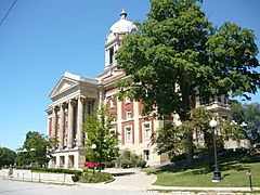
Mercer County Courthouse (1909)
|
||
|
||
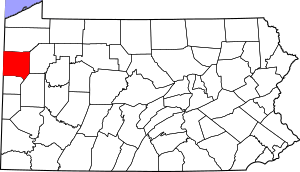
Location within the U.S. state of Pennsylvania
|
||
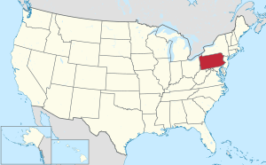 Pennsylvania's location within the U.S. |
||
| Country | ||
| State | ||
| Founded | November 7, 1803 | |
| Named for | Hugh Mercer | |
| Seat | Mercer | |
| Largest city | Hermitage | |
| Area | ||
| • Total | 683 sq mi (1,770 km2) | |
| • Land | 673 sq mi (1,740 km2) | |
| • Water | 10 sq mi (30 km2) 1.5%% | |
| Population
(2020)
|
||
| • Total | 110,652 | |
| • Density | 162/sq mi (63/km2) | |
| Time zone | UTC−5 (Eastern) | |
| • Summer (DST) | UTC−4 (EDT) | |
| Congressional district | 16th | |
Mercer County is a county located in Pennsylvania. In 2020, about 110,652 people lived here. The main town, or county seat, is Mercer. The biggest city in the county is Hermitage. Mercer County is in the northwest part of Pennsylvania. It is also part of the larger Greater Pittsburgh area.
Contents
History of Mercer County
Mercer County was officially created in the year 1800. It started to be organized and function as a county in 1803.
Geography of Mercer County
Mercer County covers a total area of about 683 square miles. Most of this area, 673 square miles, is land. The remaining 10 square miles, or 1.5%, is water.
The county has a humid continental climate. This means it has warm summers and cold winters. For example, in Sharon, the average temperature in January is around 27.1°F. In July, it's about 72.2°F. Mercer County is also part of the Appalachian Regional Commission.
Counties Nearby
Mercer County shares its borders with several other counties:
- Crawford County (to the north)
- Venango County (to the east)
- Butler County (to the southeast)
- Lawrence County (to the south)
- Mahoning County, Ohio (to the southwest, in Ohio)
- Trumbull County, Ohio (to the west, in Ohio)
Main Roads and Highways
Many important roads run through Mercer County, making it easy to travel. These include major interstate highways and state routes:
People of Mercer County
| Historical population | |||
|---|---|---|---|
| Census | Pop. | %± | |
| 1800 | 3,228 | — | |
| 1810 | 8,277 | 156.4% | |
| 1820 | 11,681 | 41.1% | |
| 1830 | 19,729 | 68.9% | |
| 1840 | 32,873 | 66.6% | |
| 1850 | 33,172 | 0.9% | |
| 1860 | 36,856 | 11.1% | |
| 1870 | 49,977 | 35.6% | |
| 1880 | 56,161 | 12.4% | |
| 1890 | 55,744 | −0.7% | |
| 1900 | 57,387 | 2.9% | |
| 1910 | 77,699 | 35.4% | |
| 1920 | 93,788 | 20.7% | |
| 1930 | 99,246 | 5.8% | |
| 1940 | 101,039 | 1.8% | |
| 1950 | 111,954 | 10.8% | |
| 1960 | 127,519 | 13.9% | |
| 1970 | 127,175 | −0.3% | |
| 1980 | 128,299 | 0.9% | |
| 1990 | 121,003 | −5.7% | |
| 2000 | 120,307 | −0.6% | |
| 2010 | 116,638 | −3.0% | |
| 2020 | 110,652 | −5.1% | |
| U.S. Decennial Census 1790–1960 1900–1990 1990–2000 2010–2019 2020 |
|||
In 2000, there were about 120,293 people living in Mercer County. Most people, about 93%, were White. About 5% were Black or African American. Other groups made up smaller parts of the population.
The average age of people in the county was 40 years old. About 23% of the population was under 18 years old.
Population in 2020
In 2020, the population of Mercer County was 110,652.
| Race | Number of People | Percentage |
|---|---|---|
| White | 96,998 | 87.6% |
| Black or African American | 6,289 | 5.7% |
| Native American | 116 | 0.1% |
| Asian | 683 | 0.6% |
| Pacific Islander | 14 | 0.01% |
| Other/Mixed | 4,943 | 4.5% |
| Hispanic or Latino | 1,609 | 1.5% |
Education in Mercer County
Mercer County has many schools and colleges for students of all ages.
Colleges and Universities
- Grove City College (in Grove City)
- Thiel College (in Greenville)
- Pennsylvania State University, Shenango Campus (in Sharon)
- Butler County Community College, BC3 @ Linden Pointe (in Hermitage)
Career Training Schools
These schools help students learn specific job skills:
- Laurel Technical Institute (Sharon)
- Mercer County Career and Technical Center (Mercer)
- Penn State Cosmetology Academy (Hermitage)
- Sharon Regional Health System Schools of Nursing and Radiology (Sharon)
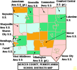
Public School Districts
Many public school districts serve the students in Mercer County:
- Crawford Central School District
- Commodore Perry School District
- Farrell Area School District
- Greenville Area School District
- Grove City Area School District
- Hermitage School District
- Jamestown Area School District
- Lakeview School District
- Mercer Area School District
- Reynolds School District
- Sharon City School District
- Sharpsville Area School District
- West Middlesex Area School District
- Wilmington Area School District
Other Schools
- Charter Schools: Keystone Education Center Charter School in Greenville serves students in grades 7-12.
- Private Schools:
* Kennedy Catholic High School (Hermitage) * St Michael's Elementary School (Greenville)
Fun Things to Do in Mercer County
Mercer County offers places for outdoor activities and interesting visits.
There is one Pennsylvania state park here. Maurice K. Goddard State Park is named after a former state official. You can find it near Stoneboro.
The Wendell August Forge is a special place. It is the last working metal forge in Pennsylvania. You can visit to see how metal items are made. It burned down in 2010 but has since reopened in new buildings.
Towns and Communities
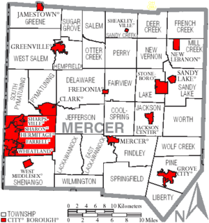
Mercer County has different types of communities. These include cities, boroughs, and townships.
Cities
Boroughs
- Clark
- Fredonia
- Greenville
- Grove City
- Jackson Center
- Jamestown
- Mercer (This is the county seat)
- New Lebanon
- Sandy Lake
- Sharpsville
- Sheakleyville
- Stoneboro
- West Middlesex
Townships
- Coolspring
- Deer Creek
- Delaware
- East Lackawannock
- Fairview
- Findley
- French Creek
- Greene
- Hempfield
- Jackson
- Jefferson
- Lackawannock
- Lake
- Liberty
- Mill Creek
- New Vernon
- Otter Creek
- Perry
- Pine
- Pymatuning
- Salem
- Sandy Creek
- Sandy Lake
- Shenango
- South Pymatuning
- Springfield
- Sugar Grove
- West Salem
- Wilmington
- Wolf Creek
- Worth
Census-Designated Places
These are areas identified by the U.S. Census Bureau for statistical purposes:
Other Small Communities
Mercer County also has many smaller, unincorporated communities:
- Blacktown
- Briscoe Springs
- Carlton
- Charleston
- Clarks Mills
- Delaware Grove
- Fairview (village)
- Hadley
- Kennard
- Kremis
- London
- Maysville
- Milledgeville
- New Vernon
- North Liberty
- Oniontown
- Osgood
- Petersburg
- Shenango (village)
- Transfer
- Williams Corners
Former Communities
- Hickory Township became the city of Hermitage.
- Wheatland joined the city of Hermitage in 2024.
See also
 In Spanish: Condado de Mercer (Pensilvania) para niños
 | Lonnie Johnson |
 | Granville Woods |
 | Lewis Howard Latimer |
 | James West |


