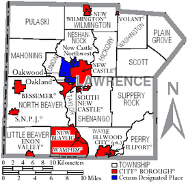
Lawrence County, Pennsylvania facts for kids
Quick facts for kids
Lawrence County
|
|||
|---|---|---|---|
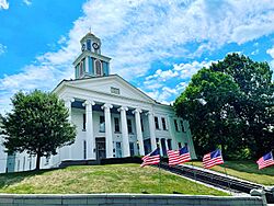
Lawrence County Courthouse
|
|||
|
|||
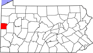
Location within the U.S. state of Pennsylvania
|
|||
 Pennsylvania's location within the U.S. |
|||
| Country | |||
| State | |||
| Founded | March 20, 1849 | ||
| Named for | USS Lawrence | ||
| Seat | New Castle | ||
| Largest city | New Castle | ||
| Area | |||
| • Total | 363 sq mi (940 km2) | ||
| • Land | 358 sq mi (930 km2) | ||
| • Water | 4.5 sq mi (12 km2) 1.3% | ||
| Population
(2020)
|
|||
| • Total | 86,070 | ||
| • Density | 240/sq mi (90/km2) | ||
| Time zone | UTC−5 (Eastern) | ||
| • Summer (DST) | UTC−4 (EDT) | ||
| Congressional district | 16th | ||
Lawrence County is a county in Pennsylvania. It's like a special area within the state. In 2020, about 86,070 people lived here. The main city and county seat is New Castle.
The county was created on March 20, 1849. It was made from parts of Beaver and Mercer counties. Lawrence County is part of the larger Greater Pittsburgh area.
Contents
History of Lawrence County
Lawrence County was formed on March 20, 1849. It was created from pieces of Beaver and Mercer counties. This happened because the city of New Castle was growing very fast. New Castle was mostly in Mercer County but was quickly spreading into Beaver County.
The county was named after the USS Lawrence. This was the main ship of Commodore Oliver Hazard Perry. His ship was damaged in a big battle called the Battle of Lake Erie in 1813. This battle happened during the War of 1812. Some local soldiers were on that ship. The ship itself was named after James Lawrence, another naval officer who died in the War of 1812.
Lawrence County Flag
In August 1981, a county leader named Paul L. Tanner suggested making a flag for Lawrence County. He also wanted flags for each of the county's 27 towns and areas. These flags would be shown at the courthouse.
On January 12, 1982, the county announced a contest to design the county flag. People living in Lawrence County could send in their ideas. The winner would get $100. A special committee was formed to choose the best design. The leaders said they wanted to "generate public spirit" and get citizens involved.
The winning flag design was announced on June 4, 1982. A special event was held at the courthouse on June 15, 1982. Rosemary Ann Marino, an artist from New Castle, won the contest. She sent in several designs, and hers was chosen from 43 entries.
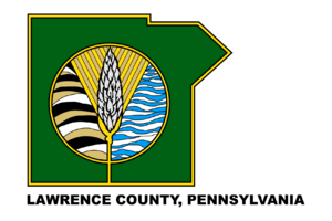
The flag shows the shape of Lawrence County in green. It has a gold edge on a white background. The words "Lawrence County, Pennsylvania" are at the bottom. In the middle, there's a symbol with a shaft of wheat. This wheat stands for good fortune. Behind it are rolling farmlands on the left and waves of water on the right.
At the ceremony, Rosemary Marino received her $100 prize. The governor of Pennsylvania, Dick Thornburgh, also sent a message of congratulations.
Geography of Lawrence County
Lawrence County covers about 363 square miles. Most of this is land (358 square miles), and a small part is water (4.5 square miles). Important rivers and creeks in the county include the Shenango River, Neshannock Creek, and the Mahoning River. These rivers come together to form the Beaver River. Also, Slippery Rock Creek and Connoquenessing Creek flow into the Beaver River.
Climate
Lawrence County has a humid continental climate. This means it has warm summers and cold winters. In New Castle, the average monthly temperatures range from about 27.7 degrees Fahrenheit in January to 72.2 degrees Fahrenheit in July.
Neighboring Counties
- Mercer County (north)
- Butler County (east)
- Beaver County (south)
- Columbiana County, Ohio (southwest)
- Mahoning County, Ohio (west)
Population of Lawrence County
| Historical population | |||
|---|---|---|---|
| Census | Pop. | %± | |
| 1850 | 21,079 | — | |
| 1860 | 22,999 | 9.1% | |
| 1870 | 27,298 | 18.7% | |
| 1880 | 33,312 | 22.0% | |
| 1890 | 37,517 | 12.6% | |
| 1900 | 57,042 | 52.0% | |
| 1910 | 70,032 | 22.8% | |
| 1920 | 85,545 | 22.2% | |
| 1930 | 97,258 | 13.7% | |
| 1940 | 96,877 | −0.4% | |
| 1950 | 105,120 | 8.5% | |
| 1960 | 112,965 | 7.5% | |
| 1970 | 107,374 | −4.9% | |
| 1980 | 107,150 | −0.2% | |
| 1990 | 96,246 | −10.2% | |
| 2000 | 94,639 | −1.7% | |
| 2010 | 91,108 | −3.7% | |
| 2020 | 86,070 | −5.5% | |
In 2000, there were about 94,643 people living in Lawrence County. Most people were White (about 95%). About 3.6% were Black or African American.
2020 Census Information
Here's a look at the different groups of people living in Lawrence County in 2020:
| Race | Number of People | Percentage |
|---|---|---|
| White (not Hispanic) | 75,811 | 88.1% |
| Black or African American (not Hispanic) | 3,546 | 4.12% |
| Native American (not Hispanic) | 75 | 0.1% |
| Asian (not Hispanic) | 321 | 0.37% |
| Pacific Islander (not Hispanic) | 4 | 0.01% |
| Other/Mixed (not Hispanic) | 4,658 | 5.4% |
| Hispanic or Latino | 1,655 | 2% |
Statistical Areas
The U.S. government has named Lawrence County as the New Castle, PA Micropolitan Statistical Area. A micropolitan area is a city and its surrounding areas that are closely connected. In 2010, this area was the 3rd most populated in Pennsylvania.
Lawrence County is also part of a larger area called the Pittsburgh–New Castle–Weirton combined statistical area (CSA). This combines the populations of several counties in Pennsylvania, West Virginia, and Ohio. It's like a very large region where many cities and towns are connected. In 2010, this larger area had over 2.6 million people.
Education in Lawrence County
Lawrence County has many places for learning, from colleges to local schools.
Colleges and Universities
- Westminster College - New Wilmington
Community and Technical Colleges
- Butler Community College Lawrence Crossing Campus
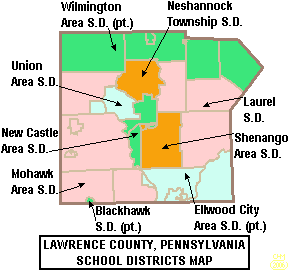
Public School Districts
- Blackhawk School District (part)
- Ellwood City Area School District (part)
- Laurel School District
- Mohawk Area School District
- Neshannock Township School District
- New Castle Area School District
- Shenango School District
- Union Area School District
- Wilmington Area School District (part)
Tech Schools
- Lawrence County Career Technology Center - Shenango Township
- New Castle School of Trades - Union Township
Private Schools
- Apple Grove School - New Wilmington
- Cherry Hill School - New Wilmington
- Cotton School - New Wilmington
- Ellwood City Children's Center, Inc.
- Faith Country Chapel Preschool and Kindergarten - New Castle
- Fayette School - Volant
- Hillside Parochial School - New Wilmington
- Indian Run School - New Wilmington
- J R Wilson School - New Wilmington
- Ligo School - New Wilmington
- Little Beaver Parochial School - Enon Valley
- Lusk School - Volant
- Meadow Lark School - New Wilmington
- New Castle Christian Academy - New Castle
- Parents Preschool Ellwood City
- Shepherd School - Volant
- St Vitus Catholic School - New Castle
- Thorn Hill School - Volant
- Westminster Preschool - New Wilmington
Libraries
- Ellwood City Area Public Library
- F D Campbell Memorial Library - Bessemer
- Lawrence County Federated Library System - New Castle
- New Castle Public Library
Transportation in Lawrence County
Getting around Lawrence County is possible by air, public buses, and many roads.
Airports
- New Castle Municipal Airport
Public Transit
- New Castle Area Transit Authority
Major Roads and Highways

 I-76 / Penna Turnpike
 I-79
I-79 I-376
I-376 US 19
US 19 US 224
 US 422


 US 422 Bus.
 PA 18
PA 18 PA 65
PA 65 PA 108
 PA 158
 PA 168
 PA 208
 PA 288
 PA 317
 PA 351
 PA 388
 PA 488
 PA 551
 PA 956
Fun and Recreation
Lawrence County offers many places to enjoy nature and outdoor activities.
Parks
- Cascade Park (New Castle)
- Ewing Park (Ellwood City)
- Gaston Park (New Castle)
- McConnells Mill State Park (Slippery Rock Twp)
- Pearson Park (Neshannock Twp)
- West Park Nature Center (Union Twp)
- Marti Park
- New Wilmington Borough Park
State Game Lands
These are areas set aside for wildlife and outdoor activities like hunting and hiking.
- SGL 148 (New Beaver)
- SGL 150 (Pulaski Twp)
- SGL 151 (Washington Twp near Volant)
- SGL 178 (Neshannock Twp north of New Castle)
- SGL 216 (Scott Twp near Harlansburg)
Trails
- North Country Trail (entire trail)
- North Country Trail (local)
- Stavich Bike Trail
- Neshannock Creek Trail
Communities in Lawrence County
In Pennsylvania, there are different types of towns and areas. These include cities, boroughs, and townships. Here are the communities you can find in Lawrence County:
Cities
- New Castle (This is the county seat, meaning it's where the county government is located.)
Boroughs
Townships
- Hickory
- Little Beaver
- Mahoning
- Neshannock
- North Beaver
- Perry
- Plain Grove
- Pulaski
- Scott
- Shenango
- Slippery Rock
- Taylor
- Union
- Washington
- Wayne
- Wilmington
Census-Designated Places
These are special areas defined by the U.S. Census Bureau for collecting population data. They are not official towns or cities.
Unincorporated Communities
These are smaller places that are part of larger towns or townships.
- Altman
- Belmar Park
- Brent
- Burnstown
- Castlewood
- Coaltown
- Coaltown Hill
- Cottage Grove
- Coverts
- Derringer Corners
- Drake
- Duckrun
- Eastbrook
- East New Castle
- Edinburg
- Elliott Mills
- Energy
- Fayette
- Gibsondale
- Grant City
- Harbor
- Harbor Bridge
- Harlansburg
- Hillsville
- Jackson Knolls Gardens
- Joyce
- Lawrence Junction
- Mahoningtown
- McCaslin
- McConnells Mill
- Moravia
- Mount Air
- Mount Jackson
- Nashua
- Neshannock Falls
- New Castle Junction
- Newburg
- Newpoint
- North Edinburg
- Old Enon
- Park Gate
- Parkstown
- Peanut
- Possum Hollow
- Princeton
- Pulaski
- Robinson
- Rockville
- Rose Point
- Sheep Hill
- Skidmore
- Sunnyside
- Sunset Valley
- Villa Maria
- Walmo
- Westview Heights
- Wiegletown
- Willow Grove
- Wurtemburg
Former Community
Big Beaver Borough became an official borough in 1958. Before that, it was known as Big Beaver Township. When Lawrence County was created in 1849, the county line split Big Beaver. The part in Lawrence County is now called New Beaver Borough.
Population Ranking of Communities (2010 Census)
This table shows the communities in Lawrence County ranked by how many people lived there in 2010.
† county seat
| Rank | City/Town/etc. | Type of Community | Population (2010 Census) |
|---|---|---|---|
| 1 | † New Castle | City | 23,273 |
| 2 | Ellwood City (partially in Beaver County) | Borough | 7,921 |
| 3 | New Wilmington | Borough | 2,466 |
| 4 | Oakwood | CDP | 2,270 |
| 5 | Oakland | CDP | 1,569 |
| 6 | New Beaver | Borough | 1,502 |
| 7 | New Castle Northwest | CDP | 1,413 |
| 8 | Ellport | Borough | 1,180 |
| 9 | Bessemer | Borough | 1,111 |
| 10 | New Bedford | CDP | 925 |
| 11 | West Pittsburg | CDP | 808 |
| 12 | Wampum | Borough | 717 |
| 13 | South New Castle | Borough | 709 |
| 14 | Frizzleburg | CDP | 602 |
| 15 | Chewton | CDP | 488 |
| 16 | Enon Valley | Borough | 306 |
| 17 | Volant | Borough | 168 |
| 18 | S.N.P.J. | Borough | 19 |
Notable People from Lawrence County
Many interesting people have come from Lawrence County! Here are a few:
- W. Thomas Andrews – a former state senator for Pennsylvania.
- Charlie Bennett – a baseball catcher who played for several Major League teams.
- George Chip – a middleweight boxing champion in the early 1900s.
- Ralph J. Cicerone – a scientist and president of the National Academy of Sciences.
- Bruce Clark – a professional football player.
- Jack Cole – a cartoonist who created the superhero Plastic Man.
- Donnie Iris – a rock singer and guitarist.
- Malik Hooker – a safety for the Indianapolis Colts in the NFL.
- Andrew R. Morgan – a U.S. astronaut.
- Trent Reznor – the lead singer for the band Nine Inch Nails.
- Raymond P. Shafer – the 39th governor of Pennsylvania.
- Robert Sterling – a film and television actor.
- Chuck Tanner – a former baseball player and manager who led the Pittsburgh Pirates to a World Series win in 1979.
- George Zambelli Sr. – famous for fireworks shows.
See also
 In Spanish: Condado de Lawrence (Pensilvania) para niños
 | George Robert Carruthers |
 | Patricia Bath |
 | Jan Ernst Matzeliger |
 | Alexander Miles |


