Ellwood City, Pennsylvania facts for kids
Quick facts for kids
Ellwood City, Pennsylvania
|
|||
|---|---|---|---|
|
Borough
|
|||
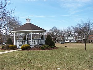
Ewing Park in Ellwood City
|
|||
|
|||
| Motto(s):
"Changing Lives, Living Change"
|
|||
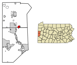
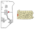
Location of Ellwood City in Beaver County, Pennsylvania.
|
|||
| Country | United States | ||
| State | Pennsylvania | ||
| Counties | Lawrence, Beaver | ||
| Established | 1892 | ||
| Named for | Isaac L. Ellwood | ||
| Area | |||
| • Total | 2.36 sq mi (6.11 km2) | ||
| • Land | 2.32 sq mi (6.02 km2) | ||
| • Water | 0.03 sq mi (0.09 km2) | ||
| Elevation | 883 ft (269 m) | ||
| Population
(2020)
|
|||
| • Total | 7,642 | ||
| • Density | 3,288.30/sq mi (1,269.58/km2) | ||
| • Demonyms | Ellwoodian | ||
| Time zone | UTC-5 (Eastern (EST)) | ||
| • Summer (DST) | UTC-4 (EDT) | ||
| ZIP code |
16117
|
||
| Area code(s) | 724, 878 | ||
| FIPS code | 42-23304 | ||
| GNIS feature ID | 1211951 | ||
Ellwood City is a town, also called a borough, in Pennsylvania, United States. Most of the town is in Lawrence County, but a small part is in Beaver County. It is located along the Connoquenessing Creek near where it meets the Beaver River.
In 2020, about 7,642 people lived in Ellwood City. The town is about 30 miles (48 km) northwest of Pittsburgh and 8 miles (13 km) southeast of New Castle. It is part of the larger Pittsburgh metropolitan area.
Contents
History of Ellwood City
Ellwood City is named after a businessman named Isaac L. Ellwood. In the past, the town was a busy place for many heavy industries. These included factories that made steel tubes and steel cars. There were also places that dug up building stone and limestone. Other businesses included foundries (where metal is melted and shaped) and machine shops. Coal mining was also an important industry.
Geography of Ellwood City
Ellwood City is located at coordinates 40.860983°N, 80.284849°W. The town covers a total area of about 2.4 square miles (6.2 km²). Most of this area, about 2.3 square miles (6.0 km²), is land. The rest, about 0.1 square miles (0.26 km²), is water.
There is a special circular area in the city, about 0.3 miles (0.48 km) across, called the Pittsburgh Circle. This circle was once a track for bicycle racing! This makes sense because Ellwood City used to make steel that was used for bicycles.
People of Ellwood City
In 2020, the population of Ellwood City was 7,642 people. The population has changed over the years:
| Historical population | |||
|---|---|---|---|
| Census | Pop. | %± | |
| 1900 | 2,243 | — | |
| 1910 | 3,902 | 74.0% | |
| 1920 | 8,958 | 129.6% | |
| 1930 | 12,323 | 37.6% | |
| 1940 | 12,329 | 0.0% | |
| 1950 | 12,945 | 5.0% | |
| 1960 | 12,413 | −4.1% | |
| 1970 | 10,857 | −12.5% | |
| 1980 | 9,998 | −7.9% | |
| 1990 | 8,894 | −11.0% | |
| 2000 | 8,688 | −2.3% | |
| 2010 | 7,921 | −8.8% | |
| 2020 | 7,642 | −3.5% | |
| 2021 (est.) | 7,564 | −4.5% | |
| Sources: | |||
In 2000, there were 8,688 people living in the borough. About 22.5% of the population was under 18 years old. About 22.1% of the people were 65 years old or older. The average age in Ellwood City was 41 years.
In 2022, Jan Williams made history by becoming the first woman of Asian descent to join the town council.
Education in Ellwood City
Students in Ellwood City attend schools that are part of the Ellwood City Area School District.
Transportation in Ellwood City
Major Roads and Highways
Several important roads and highways pass through or near Ellwood City. These roads help people travel to and from the town.
 PA 65
PA 65 PA 288
 PA 351
 PA 488
Notable People from Ellwood City
Many interesting people have come from Ellwood City. Here are a few:
- Jim Gerlach – A former U.S. Representative who served in Congress for Pennsylvania.
- Princess Ileana of Romania – She was a princess, the youngest daughter of King Ferdinand I of Romania and Queen Marie of Romania.
- Donnie Iris – A rock musician famous for his solo work and with bands like The Jaggerz and Wild Cherry.
- Stephen Johns – A former professional ice hockey player who played defense for the Dallas Stars.
- Sean Miller – A well-known college basketball coach for Xavier University.
- Matt Osborne – A professional wrestler known for his character, Doink the Clown.
- Leslie H. Sabo, Jr. – A hero from the Vietnam War who received the Medal of Honor for his bravery.
- Debra Todd – She is the Chief Justice of the highest court in Pennsylvania, the Supreme Court of Pennsylvania.
- Hack Wilson – A famous Major League Baseball player and a member of the Baseball Hall of Fame.
- George Zeber – A former professional baseball player for the New York Yankees.
Images for kids
See also
 In Spanish: Ellwood City para niños
 | Delilah Pierce |
 | Gordon Parks |
 | Augusta Savage |
 | Charles Ethan Porter |


