
McConnells Mill State Park facts for kids
Quick facts for kids McConnells Mill State Park |
|
|---|---|
|
IUCN Category III (Natural Monument)
|
|

View of the old mill in McConnell's Mill State Park
|
|

McConnells Mill State Park
Location in Pennsylvania
|
|
| Location | Lawrence, Pennsylvania, United States |
| Area | 2,546 acres (10.30 km2) |
| Elevation | 1,145 ft (349 m) |
| Established | 1957 |
| Named for | McConnells Mill |
| Governing body | Pennsylvania Department of Conservation and Natural Resources |
| Website | McConnells Mill State Park |
| Designated: | 1972 |
McConnells Mill State Park is a large state park in Lawrence County, Pennsylvania. It covers about 2,546 acres (10.3 square kilometers). The park is famous for its deep, beautiful gorge with a restored old watermill and a covered bridge at the bottom.
You can reach the mill and bridge by a road that winds through huge, room-sized boulders. The park is located along the Slippery Rock Creek, near where two major roads, US 422 and US 19, meet. McConnells Mill State Park is considered one of the "25 Must-See Pennsylvania State Parks" by the Pennsylvania Department of Conservation and Natural Resources (DCNR).
Contents
History of the Park
The Old Mill
A man named Daniel Kennedy first built a gristmill (a mill for grinding grain) on Slippery Rock Creek in 1852. Sadly, a fire destroyed this mill in 1868, but it was quickly rebuilt.
In 1875, the mill was bought by Thomas McConnell, who the park is named after. He made some big improvements! He replaced the old waterwheel with modern water turbines. He also swapped the traditional grindstones for rolling mills. This made McConnell's Mill one of the first rolling mills in the entire country.
The mill used to process different grains like oats, corn, buckwheat, and wheat. It stayed open until 1928. Later, in 1942, the land was bought by the Western Pennsylvania Conservancy. They then gave the land to the state of Pennsylvania in 1957, which is when McConnells Mill State Park officially opened.
The Covered Bridge

The McConnell's Mill Covered Bridge was built in 1874. It's a special type of bridge called a Howe truss bridge. This bridge is one of only two covered bridges in Lawrence County.
Even though it's on state park land, the county actually owns the bridge. It's a very important historical site and is listed on the National Register of Historic Places.
Fun Things to Do
Hiking and Rock Climbing
The park has many trails for hiking. Some trails even lead to a beautiful waterfall! You can also see an old limestone kiln (a type of oven) nearby.
The park's trail system is part of the North Country Trail. This is the longest National Scenic Trail in the country, stretching all the way from North Dakota to New England.
There are also two areas for climbing and rappelling (climbing down ropes). These spots are only for experienced climbers who have the right gear. The area at Breakneck Bridge is especially challenging.
- Alpha Pass Trail is a "moderate" (medium difficulty) hiking trail. It is about 1.5 miles (2.4 km) long and marked with blue signs. This trail is part of the North Country Trail. It starts at the Alpha Pass scenic view and follows the east side of Slippery Rock Creek to the Old Mill.

- Hells Hollow Trail is an "easy" hiking trail, about 0.5 miles (0.8 km) long. It starts at the Hells Hollow parking area and follows Hell Run. This trail leads you to the restored lime kiln and then to the lovely Hells Hollow Falls.
- Kildoo Trail is a "moderate" (medium difficulty) hiking trail loop. It is about 2 miles (3.2 km) long. This loop starts and ends at the McConnell's Mill Covered Bridge. It follows both sides of Slippery Rock Creek. Part of this trail is also part of the North Country Trail.
- Slippery Rock Gorge Trail is a "moderate" to "difficult" trail. Parts of it are also part of the North Country Trail and are marked with blue signs. This trail goes through different types of land. It starts in the upper Hell Run Valley, then goes down into Slippery Rock Gorge. It reaches a flat, low area (a flood plain) at the bottom of the gorge. From there, it climbs up the gorge again before following the main creek to Eckert Bridge.
Whitewater Boating
Whitewater boating is very popular on Slippery Rock Creek. The creek is rated as a Class II-III river on the International Scale of River Difficulty. This means it has medium to difficult rapids, depending on how much water is flowing.
Boating usually starts outside the park at the U.S. Route 422 bridge. It then goes under Eckert Bridge inside the park and ends at Harris Bridge. There is a place where you must carry your boat around the dam at the Old Mill. It is against the rules to go over the dam in your boat. All boaters must wear life jackets that are approved by the United States Coast Guard.
Hunting and Fishing

You can go hunting in many parts of McConnells Mill State Park. Hunters must follow the rules set by the Pennsylvania Game Commission. Some common animals you might hunt include ruffed grouse, squirrels, turkey, white-tailed deer, and rabbits. However, hunting groundhogs is not allowed in the park.
The Pennsylvania Fish and Boat Commission makes sure there are plenty of fish for anglers (people who fish). They do this by stocking (adding) trout and bass into Slippery Rock Creek.
How the Park Was Formed
The rocks you see at McConnells Mill State Park were made over 300 million years ago! Back then, this area of Pennsylvania was a coastal region. Layers of peat (decaying plants), mud, and sand piled up and were squeezed together. This process formed the bedrock (the solid rock beneath the soil).
Later, as the Earth's continental plates moved, these layers of bedrock were pushed up to form mountains. Different layers of rock had different strengths. Some wore away quickly, while others eroded much slower. This is why you see so many different rock shapes and features in the park.
The park's geology was also greatly shaped by the ice age. About 140,000 years ago, a huge glacial lake (a lake held back by a glacier) broke open. This caused a massive change in how the water flowed. The lake, which used to drain north, suddenly started draining south. This huge amount of fast-moving water carved out the deep Slippery Rock Creek Gorge that we see today.
Nature and Environment
McConnells Mill State Park is located within the Appalachian mixed mesophytic forests ecoregion. This means it's a place where you can find a mix of different kinds of trees and plants that thrive in this type of forest.
Gallery

Nearby State Parks
Here are some other state parks not too far from McConnells Mill State Park:
- Jennings Environmental Education Center (Butler County)
- Moraine State Park (Butler County)
(570.9 KB) (626 KB)
Images for kids
-
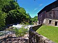
McConnells Mill with the gristmill and Slippery Rock Creek in the background.
-
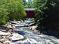
McConnells Mills Covered Bridge during the summer.
-
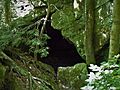
One of the many caves in the forest within the park.


.jpg)
