Slippery Rock Creek facts for kids
Quick facts for kids Slippery Rock Creek |
|
|---|---|

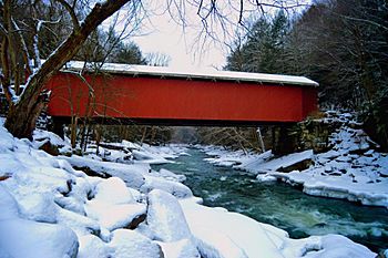
Slippery Rock Creek passes under the covered bridge at McConnells Mill State Park.
|
|
|
Location of Slippery Rock Creek mouth
|
|
| Country | United States of America |
| State | Pennsylvania |
| County | Butler Lawrence |
| Cities | Slippery Rock, PA, Ellwood City, PA |
| Physical characteristics | |
| Main source | Hilliards, Butler County, Pennsylvania 1,400 ft (430 m) 41°06′51″N 79°48′15″W / 41.11417°N 79.80417°W |
| River mouth | Connoquenessing Creek Ellwood City, Beaver County, Pennsylvania 810 ft (250 m) 40°51′31″N 80°15′24″W / 40.85861°N 80.25667°W |
| Length | 50.17 mi (80.74 km) |
| Basin features | |
| Progression | southwest |
| River system | Beaver River |
| Basin size | 409.79 square miles (1,061.4 km2) |
| Tributaries | |
Slippery Rock Creek is a small stream in western Pennsylvania, USA. It is a tributary of Connoquenessing Creek. This means it's a smaller stream that flows into a larger one.
The creek starts in Hilliards in Butler County. It then flows through McConnells Mill State Park. Finally, it joins the Connoquenessing Creek in Ellwood City. Just three miles south of where Slippery Rock Creek joins, the Connoquenessing Creek flows into the Beaver River.
Contents
Fun on the Water
Slippery Rock Creek is a popular spot for whitewater kayakers and canoeists. People from Pittsburgh and Ohio especially love to visit. The creek has exciting Class-II and Class-III rapids, which are perfect for paddlers of all skill levels.
Staying Safe on the Creek
While the creek is beautiful and fun, it's important to be careful. The rocks in the creek can be very slippery, just like its name suggests! Always wear a life vest and be aware of your surroundings, especially near McConnells Mill State Park. It's always best to go with experienced paddlers or a guide if you're new to whitewater.
Creek's Path and Waterways
Slippery Rock Creek is about 50 miles (80 kilometers) long. It starts at an elevation of about 1,400 feet (427 meters) and flows downhill to join Connoquenessing Creek at about 810 feet (247 meters). The area of land that drains into Slippery Rock Creek is called its watershed. This watershed covers about 410 square miles (1,062 square kilometers).
Tributaries of Slippery Rock Creek
Many smaller streams flow into Slippery Rock Creek. These are called its tributaries. Here are some of the main ones:
- Skunk Run
- Hell Run
- Grindstone Run
- Cheeseman Run
- Muddy Creek - This is the second largest tributary.
- Taylor Run
- Jamison Run
- Black Run
- Wolf Creek - This is the largest tributary by the amount of water it carries.
- Hogue Run
- Big Run
- Glade Run
- Long Run
- McDonald Run
- South Branch Slippery Rock Creek
- McMurray Run
- North Branch Slippery Rock Creek
- Blacks Creek
- Seaton Creek
 | Shirley Ann Jackson |
 | Garett Morgan |
 | J. Ernest Wilkins Jr. |
 | Elijah McCoy |


