Wheatland, Pennsylvania facts for kids
Quick facts for kids
Wheatland, Pennsylvania
|
|||
|---|---|---|---|
|
Former borough
|
|||

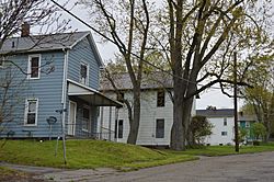
Houses on Emerson Avenue
|
|||
|
|||
| Etymology: Land of Wheat | |||

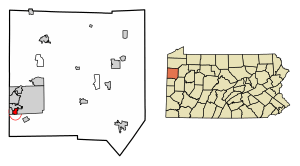
Location of Wheatland in Mercer County, Pennsylvania.
|
|||
| Country | United States | ||
| State | Pennsylvania | ||
| County | Mercer | ||
| Established | 1865 | ||
| Incorporated | February 12, 1872 | ||
| Annexed by Hermitage | January 1, 2024 | ||
| Area | |||
| • Total | 0.87 sq mi (2.26 km2) | ||
| • Land | 0.87 sq mi (2.26 km2) | ||
| • Water | 0.00 sq mi (0.00 km2) | ||
| Elevation
(center of borough)
|
914 ft (279 m) | ||
| Highest elevation
(northern borough border)
|
1,100 ft (300 m) | ||
| Lowest elevation | 830 ft (250 m) | ||
| Population
(2020)
|
|||
| • Total | 583 |
||
| • Estimate
(2021)
|
578 | ||
| • Density | 666.67/sq mi (257.41/km2) | ||
| Time zone | UTC-4 (EST) | ||
| • Summer (DST) | UTC-5 (EDT) | ||
| Zip code |
16161
|
||
| Area code(s) | 724 | ||
Wheatland was a small town, known as a borough, in Mercer County, Pennsylvania, United States. It was located along the Shenango River. In 2020, about 583 people lived there.
On January 1, 2024, Wheatland officially joined with the nearby city of Hermitage. This happened after people in both communities voted to approve the merger in November 2022.
Contents
History of Wheatland
Before Wheatland became a town, the land was mostly farmland. Two families, the Shillings and the Canons, owned most of it. An early doctor for the whole Shenango Valley, Dr. John Mitcheltree, also lived here.
How Wheatland Started and Grew
Wheatland was planned out in 1865. It officially became a borough on February 12, 1872. It was designed as a "company town" for the Wheatland Iron Co. and Wheatland Bessemer Steel Co. This means the town was built to support the workers and operations of these big factories.
For many years, Wheatland was a busy place for manufacturing. In 1940, a lumbermill opened, adding more jobs.
Changes to Wheatland's Borders
Over the years, Wheatland's size changed a few times. In 1908, a nearby borough tried to take over a part of Wheatland, but a court stopped it.
Later, Wheatland did add some land from Hickory Township. This happened in 1918 and again in 1952. These additions brought Wheatland to its final size before it merged with Hermitage.
The 1985 Tornado Disaster
On May 31, 1985, a very powerful tornado hit Wheatland. It was an F5 tornado, which is the strongest kind. Over 100 buildings in Wheatland were destroyed. Sadly, 18 people died because of this tornado, mostly in a nearby town called Niles, Ohio.
School District Challenges
From 2002 to 2007, Wheatland tried to create its own school district. Before this, students from Wheatland went to schools in the Farrell Area School District. Many people had moved to Wheatland specifically for the Farrell schools.
This effort caused a lot of disagreement. Some residents even sued, wanting Wheatland to join the West Middlesex Area School District instead. A high court in Pennsylvania eventually decided that Wheatland should stay with the Farrell district.
Leaders and Merger Talks
Thomas R. Stanton was Wheatland's mayor from 1990 to 2009. He worked hard to keep Wheatland independent. He helped get state money to improve the town and support its residents.
In 2004, there was a big idea to combine Wheatland with several other towns, including Hermitage, Sharon, Farrell, and Sharpsville, to form a new "Shenango Valley City." The governor of Pennsylvania supported this idea. However, voters decided against it.
The Final Merger with Hermitage
In 2018, Wheatland residents voted to explore staying independent. But by November 8, 2022, they voted to join Hermitage instead. This merger happened on January 1, 2024.
One main reason for the merger was that it was becoming hard for Wheatland to afford to run the borough on its own. Hermitage also had a more business-friendly approach. The last meeting of the Wheatland Borough Council was on December 12, 2023. The old council hall will become a museum about Wheatland's history.
Geography
Wheatland was located at 41°12′1″N 80°29′45″W / 41.20028°N 80.49583°W.
The United States Census Bureau reported that the borough covered about 0.9 square miles (2.26 square kilometers) of land. There was no water area within its borders.
Population Information
| Historical population | |||
|---|---|---|---|
| Census | Pop. | %± | |
| 1880 | 583 | — | |
| 1890 | 575 | −1.4% | |
| 1900 | 655 | 13.9% | |
| 1910 | 955 | 45.8% | |
| 1920 | 1,742 | 82.4% | |
| 1930 | 1,518 | −12.9% | |
| 1940 | 1,421 | −6.4% | |
| 1950 | 1,402 | −1.3% | |
| 1960 | 1,813 | 29.3% | |
| 1970 | 1,421 | −21.6% | |
| 1980 | 1,132 | −20.3% | |
| 1990 | 760 | −32.9% | |
| 2000 | 748 | −1.6% | |
| 2010 | 632 | −15.5% | |
| 2020 | 583 | −7.8% | |
| 2021 (est.) | 578 | −8.5% | |
| Sources: | |||
In 2000, the population of Wheatland was 748 people. The town had 349 households. About 17.8% of these households had children under 18 living with them.
The population included people of different backgrounds. Most residents were White (85.96%), and 12.03% were African American. About 1.07% of the population was Hispanic or Latino.
The median age in Wheatland was 46 years old. This means half the people were younger than 46 and half were older. About 27.7% of the population was 65 years or older.
The average income for a household in Wheatland in 2000 was $27,596. About 14.4% of the people lived below the poverty line.
See also
 In Spanish: Wheatland (Pensilvania) para niños
 | Percy Lavon Julian |
 | Katherine Johnson |
 | George Washington Carver |
 | Annie Easley |


