Mill Village, Pennsylvania facts for kids
Quick facts for kids
Mill Village, Pennsylvania
|
|
|---|---|
|
Borough
|
|

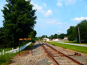
Site of the Mill Village station along the Erie Railroad
|
|

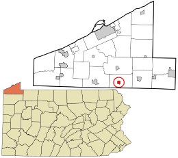
Location in Erie County and the U.S. state of Pennsylvania.
|
|
| Country | United States |
| State | Pennsylvania |
| County | Erie |
| Area | |
| • Total | 0.92 sq mi (2.38 km2) |
| • Land | 0.92 sq mi (2.38 km2) |
| • Water | 0.00 sq mi (0.00 km2) |
| Elevation
(Borough benchmark)
|
1,206 ft (368 m) |
| Highest elevation
(south borough boundary)
|
1,320 ft (400 m) |
| Lowest elevation
(Tributary to French Creek)
|
1,160 ft (350 m) |
| Population
(2020)
|
|
| • Total | 388 |
| • Density | 422.20/sq mi (163.09/km2) |
| Time zone | UTC-4 (EST) |
| • Summer (DST) | UTC-5 (EDT) |
| ZIP code |
16427
|
| Area code(s) | 814 |
Mill Village is a small town, also called a borough, in Erie County, Pennsylvania, United States. In 2020, about 394 people lived there. Mill Village is part of the larger Erie area.
Location and Landscape
Mill Village is found in the southern part of Erie County. It is surrounded by LeBoeuf Township. A main road, U.S. Route 6, goes through the borough. This road leads east about 7 miles to Union City. It also goes southwest about 8 miles to Cambridge Springs. The city of Erie is about 19 miles north.
Mill Village covers about 2.4 square kilometers (0.92 square miles) of land. There is no water area within the borough. It is located on the eastern edge of the valley of French Creek. This creek is part of the Allegheny River system.
People and Population
| Historical population | |||
|---|---|---|---|
| Census | Pop. | %± | |
| 1880 | 388 | — | |
| 1890 | 320 | −17.5% | |
| 1900 | 321 | 0.3% | |
| 1910 | 290 | −9.7% | |
| 1920 | 247 | −14.8% | |
| 1930 | 233 | −5.7% | |
| 1940 | 259 | 11.2% | |
| 1950 | 324 | 25.1% | |
| 1960 | 336 | 3.7% | |
| 1970 | 372 | 10.7% | |
| 1980 | 427 | 14.8% | |
| 1990 | 429 | 0.5% | |
| 2000 | 412 | −4.0% | |
| 2010 | 412 | 0.0% | |
| 2020 | 394 | −4.4% | |
| 2021 (est.) | 390 | −5.3% | |
| Sources: | |||
In the year 2000, there were 412 people living in Mill Village. These people lived in 149 households, and 116 of these were families. The population density was about 452.6 people per square mile. Most of the people living in the borough were White (98.30%).
About 38.3% of the households had children under 18 years old. Most households (66.4%) were married couples living together. About 17.4% of all households were single individuals. Also, 8.7% of households had someone aged 65 or older living alone. The average household had about 2.77 people.
The population of Mill Village is spread across different age groups. About 29.9% of the people were under 18 years old. About 27.9% were between 25 and 44 years old. And 11.9% were 65 years or older. The average age in the borough was 37 years.
See also
 In Spanish: Mill Village para niños
 | May Edward Chinn |
 | Rebecca Cole |
 | Alexa Canady |
 | Dorothy Lavinia Brown |

